19 FEBRUARY 1997 - KEY PARAMETERS ON ISOBARIC SURFACES FOR 00.00 UTC
by ZAMG
19 February 1997/00.00 UTC - Meteosat IR image; red: height contours 1000 hPa, green: height contours 500 hPa
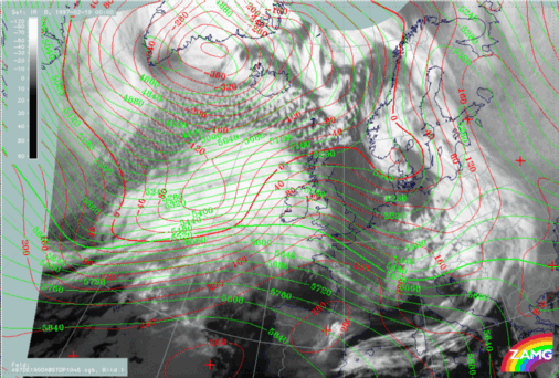
Surface (1000 hPa) and upper level height (500 hPa) show the most intensive trough features at the rear of the frontal cloud systems but also connected to the cloud head, as for instance a distinct surface low which appears in the centre of the cloud head area. The surface trough extends along the rearward Cold Front edge in south-western directions and an upper level trough line appears at the westernmost rear of the whole cloud system. Trough, west, south-west stream and ridge fit quite well to the Cold and Warm Front cloud configurations.
19 February 1997/00.00 UTC - Meteosat IR image; blue: thermal front parameter (TFP) 500/850 hPa, green: equivalent thickness 500/850 hPa, red dashed:
temparature advection - CA 1000 hPa, red solid: temparature advection - WA 1000 hPa
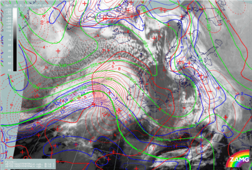
The image above combines three key parameters typical for frontal conditions: the equivalent thickness, the thermal front parameter (TFP) and temperature advection (TA). An almost classical situation can be diagnosed with the TFP close to the leading edge of the frontal cloud bands, the zone of high thickness gradients within (for the Warm Front) and partly within (for the Cold Front) the cloud bands, and huge maxima of warm advection (WA) and cold advection (CA) accompanying the Warm and Cold Front respectively.
Such a distribution is indicative of an Ana Front type of Cold Front, a fact which can best be checked with help of vertical cross sections (compare
Use of vertical cross sections for 00.00 UTC
).


