09 - 10 APRIL 1996 - RAPID CYCLOGENESIS: DIAGNOSIS FOR 09 APRIL 12.00 UTC
by ZAMG
|
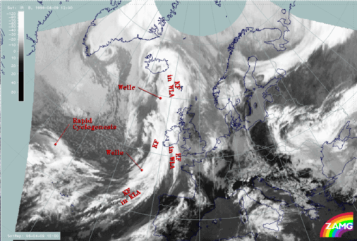
09 April 1996/12.00 UTC - Meteosat IR image; SatRep overlay: names of conceptual models
|
09 April 1996/12.00 UTC - Meteosat IR enhanced image
|
|
|
|
|
|
|
|
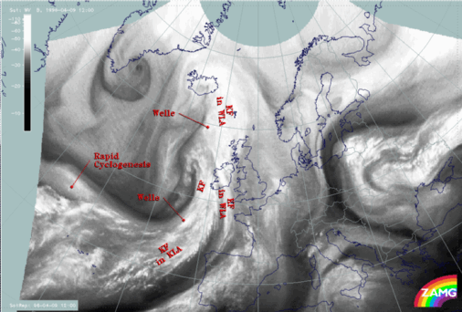
09 April 1996/12.00 UTC - Meteosat WV image; SatRep overlay: names of conceptual models
|
|
The satellite image shows at 12.00 UTC a typical situation for rapid cyclogenesis above the Atlantic at approximately 45N/35W (for more information see also
Conceptual Models: Rapid Cyclogenesis
). Within the image a frontal cloud band accompanied by partly cold (high) cloud tops (right image top) can be observed, extending from the Atlantic eastward to approximately 43N/21W. The area of Rapid Cyclogenesis is characterized by a bulge-like cloud head configuration. In contrast to the frontal cloud band, the cloud tops of the cloud head are much warmer (lower). In the WV image (left image bottom) two black stripes (dry air) can be observed, which is typical for a Rapid Cyclogenesis. Both transition zones are an indication for the jet axis, which mostly corresponds with a height of approximately 300 hPa. Very often the dry zone between frontal cloud band and the cloud head is calleda
dry tongue.
09 April 1996/12.00 UTC - Meteosat IR image; magenta: height contours 1000 hPa, green: positive vorticity advection (PVA) 500 hPa, red: temperature
advection - WA 1000 hPa
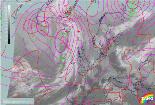
The figure above shows a nearly classical distribution of the relevant key parameters (see also the first part of this case study
Introduction and Conceptual Models for 09 April 1996/06.00 UTC). A surface low lies upstream of the
merging zone between cloud head and frontal cloud band. The
merging zone is also characterized by strong warm advection. The maximum of warm advection can be found situated a little upstream of the
merging zone, which is also typical for a Rapid Cyclogenesis. The field of PVA contains only a very weak maximum at 500 hPa. The reason for this is that the cloud head is not in the left exit region of a jet streak but in the area of the entrance region.
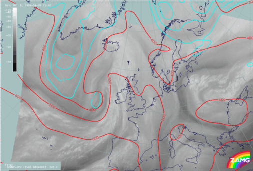
09 April 1996/12.00 UTC - Meteosat WV image; yellow: isotachs 300 hPa, black: shear vorticity 300 hPa
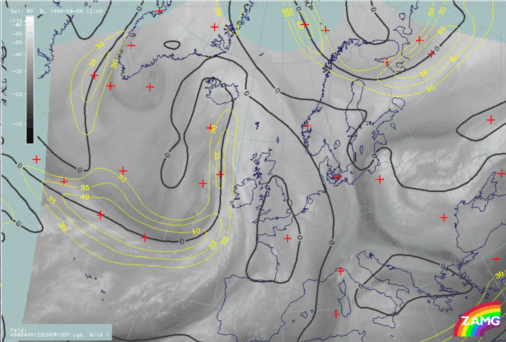
The image above contains a broad zone of high wind velocities at 300 hPa. Due to the large distance between grid points (about 150 km) the model does not differentiate between the northern jet streak (poleward side of the cloud head) and the southern (between cloud head and frontal cloud band). This is also indicated by the zero line of shear vorticity which runs within the area of the cloud head nearly in the centre of the jet axis indicated in the WV imagery. The only indication by the model that two jet streaks exist can be found in the
bulge-formed isotachs situated upstream of the cloud head. Within the WV imagery both jet axes can be clearly identified due to the sharp transition zones between moist (anticyclonic side of jet) and dry air (cyclonic side of jet).
|
09 April 1996/12.00 UTC - Meteosat IR image; cyan: potential vorticity 310K, red: isobars
|
09 April 1996/12.00 UTC - Meteosat IR image; cyan: potential vorticity 305K, red: isobars
|
|
|
|
The two figures above show the potential vorticity on isentropic surfaces. Investigations have shown that potential vorticity is a good indicator for whether the cloud head develops within its maturing stage through a
cyclone-like formed cloud spiral, or dissolves after a couple of hours. The indication for this development is given by the so-called PV anomaly (values of the PV between 1 and 2 *10
-6m
2K sec
-1kg
-1). This anomaly is connected with a lowered tropopause which overruns a low level baroclinic zone. It induces a cyclonic circulation within the upper levels of the troposphere which weakens towards the ground. As a consequence of warm advection, a low-level PV anomaly develops slightly east of the upper-level PV anomaly. Due to the vertical motion within the area of these anomalies, an alternate intensification takes place. This leads first to a downward and an upward growing which ends in a coupling of both anomalies. The result of this process is a cyclonic circulation throughout the whole troposhere (for more information see also
Conceptual Models: Rapid Cyclogenesis
). The images above include the potential vorticity on two isentropic surfaces:
- On the isentropic surface of 310K (higher surface) (left image)
- On the isentropic surface of 305K (lower surface) (right image)
In the ideal case the PV anomaly should be situated between the frontal cloud band and the cloud head (area of the dry tongue - Black Stripe in
the WV image). In the case of cloud heads where, during the maturing stage a cloud spiral develops, the anomaly often can be observed down to approximately 400 to 550 hPa. Within both images no potential vorticity anomaly can be observed within the area of Rapid Cyclogenesis. The IPV anomaly can at both heights be found displaced too far to the west. This leads to the fact that no dry stratospheric air has protruded downward between 400 to 550 hPa. Due to the missing potential vorticity anomaly no development of the cloud head to a cyclone-like formed cloud spiral can be expected. Therefore the cloudiness of the Rapid Cyclogenesis will dissolve after a couple of hours.
The reason why there is no further development often has two possibilities:
- The PV anomaly is too high, with the result that the induced cyclonic circulation does not reach the lower levels of the troposphere - as
described above, the typical heights for the PV anomaly can be found between 400 to 550 hPa;
- The static stability is too high - the induced circulation may only reach the ground if the static stability is sufficiently low.