09 - 10 APRIL 1996 - MESOSCALE CLOUD BAND: DIAGNOSIS FOR 09 APRIL 12.00 UTC
by ZAMG
|
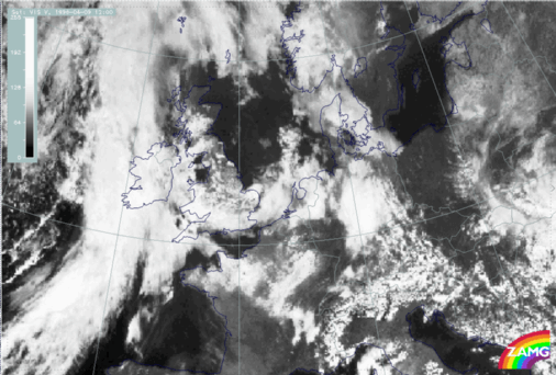
09 April 1996/12.00 UTC - Meteosat VIS image
|
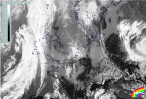
09 April 1996/12.00 UTC - Meteosat IR image
|
|
|
|
|
|
|
|
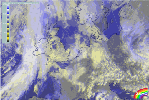
09 April 1996/12.00 UTC - Meteosat VIS + IR image
|
|
The satellite images at 12.00 UTC contain a cyclonically curved cloud band extending from the North Sea (approximately 53N/04W) across the coast of the Netherlands and south England to east Ireland where it merges with the frontal cloud band of the Cold Front in Warm Advection (compare
Cold Front in Warm Advection
). Within the VIS image (left image top) this cloud band is characterized by high pixel values indicating high albedo. In contrast to this, within the IR image (right image top) this cloud band is mostly characterized by small values indicating warm cloud tops. Only above the North Sea in front of and above the north-west coast of the Netherlands, can high pixel values also be observed within the IR image. The distribution of the pixel values of both images leads to the fact that the cloud band consists mostly of deep cloudiness. Only above the North Sea has multi-level cloudiness developed within this system. This analysis can also be observed within the third image which is a special enhancement combination of the IR and VIS images (left image bottom):
- High pixel values within the VIS image and low pixel values within the IR image - yellow - indication for low level cloudiness,
- Low pixel values within the IR image and high pixel values within the VIS image - blue - indication for high level cloudiness,
- High pixel values within the VIS image and high pixel values within the IR image - white - indication for multi-level cloudiness.
As mentioned above, most of the pixel values within the cloud band are coloured/enhanced in yellow (low level cloudiness); only above the North Sea in front of and above the north-west coast of the Netherlands are they coloured/enhanced in white (multi-level cloudiness).
To get an overview, and for the analysis of this small scale cloud band, the relevant ECMWF analysis will be discused within the paragraphs below.
|
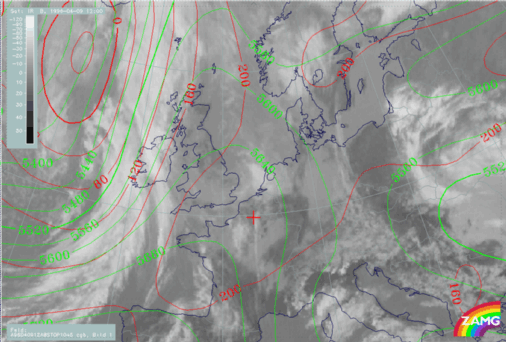
09 April 1996/12.00 UTC - Meteosat IR image; red: height contours 1000 hPa, green: height contours 500 hPa
|
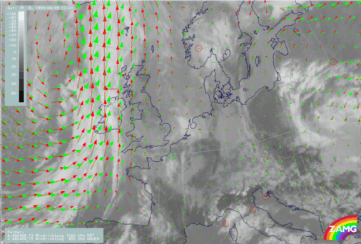
09 April 1996/12.00 UTC - Meteosat IR image; red: wind vectors 1000 hPa, green: wind vectors 850 hPa
|
|
|
|
The left image above contains the superimposed height contours at 500 and 1000 hPa. This parameter combination describes the flow and pressure distribution near the surface and in the middle of the troposphere. While the field of the height contours at 500 hPa shows a ridge within the area of the small scale cloud band, the height contours at 1000 hPa are characterized by a trough. The form of the isobars at 1000 hPa is typical for a weak surface low. This assumption is confirmed by the second image which contains the superimposed wind vectors at 850 hPa and 1000 hPa (right image top). The centre of the low can therefore be found due to the distribution of the wind vectors above north-east France.
|
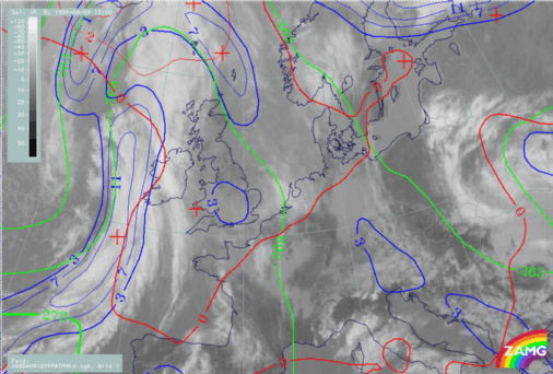
09 April 1996/12.00 UTC - Meteosat IR image; blue: thermal front parameter (TFP) 500/850 hPa, green: equivalent thickness 500/850 hPa, red:
temperature advection - WA 1000 hPa
|
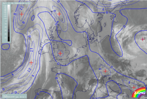
09 April 1996/12.00 UTC - Meteosat IR image; blue: thermal front parameter (TFP) 500/850 hPa
|
|
|
|
The left image above, with the superimposed parameter combination of TFP, equivalent thickness and warm advection, describes the thermal situation within the lower and mid-levels of the troposphere. The equivalent thickness field contains no crowding zone within the area of the cloud band. The absence of the crowding zone can be interpreted as indicating that the model makes no differentiation between the air masses which are situated in front of and behind the cloud band. As a consequence, no pronounced baroclinicity exists. Looking at the distribution of the TFP it can be seen that there is only a very weak TFP within the cloud band above south England. Within the rest of the cloud band no TFP greater than 3 units can be observed. Compared with the superimposed TFP without thresholds (right image top) the whole cloud band can be found within an area where the TFP is very weak (values less than 3 units). The third parameter, the field of warm advection, shows that the cloud band is within weak warm advection. There is no pronounced temperature gradient between the air
masses situated in front of and behind the cloud band, which can also be interpreted as indicating that no intensification or development of the cloud band can be expected.
Summing up, from this point of view the ECMWF model does not analyse this cloud band. The reason for this probably can be found in the grid resolution of the model of about 150 km. The only hint or indication by the model is a very weak TFP which has values below 3 units.
Another possibility to get more information about this cloud band is to analyse computed cross sections through this system. With the help of this method the forecaster gets a lot of additional information about the vertical structure of meteorological systems.
09 April 1996/12.00 UTC - Meteosat IR image; ECMWF grid superimposed; position of vertical cross section indicated
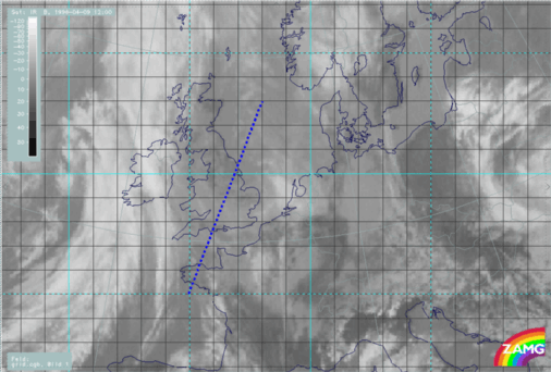
The image above contains the superimposed calculated cross section (dashed blue line) through the small scale cloud band.
09 April 1996/12.00 UTC - Vertical cross section; black: isentropes (ThetaE), blue: relative humidity, orange thin: IR pixel values, orange thick: WV
pixel values
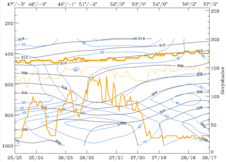
The pixel values of the IR (thin) and especially of the VIS (middle) image show the cloud band between the ECMWF gridpoints starting at approximately 26/22 (rear cloud edge) to approximately 27/20 (leading cloud edge). Within this area the equivalent potential temperature is characterized by an upper level frontal system which can be found between 800 and 600 hPa. The distribution of the crowding zone of the equivalent potential temperature classifies the system as an Occlusion - like cloud band. The third parameter within the cross section is relative humidity. The vertical distribution of this parameter shows the position (horizontal and vertical extension) of the frontal cloudiness. Therefore high values can be found within and beneath the crowding zone of the equivalent potential temperature, greater than 80% whereas within the higher layers of the troposphere the humidity values are much lower, approximately 50 to 60%.