29 MAY 2000 - CROSS SECTIONS
by FMI
In this section the thermodynamic circumstances important for the development of the pre-frontal Convergence Line will be investigated. This is done mainly by using vertical cross-sections based on ECMWF analyses, however the Aladin model analysis is used to some extent. The cross-sections presented below are all made along the line shown in the image below. This line lies approximately west - east, across the whole weather system, and includes both the Cold Front and the Convergence Line. The equivalent potential temperature and the brightness of the Meteosat infrared and water vapour channels are shown in all the cross-sections presented below, in addition to some other parameters of interest.
29 May 2000/12.30 UTC - Meteosat IR image; position of vertical cross section indicated
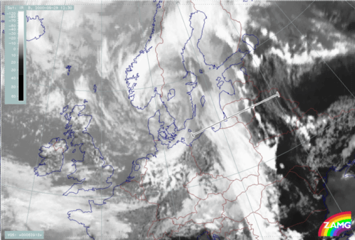
The gradient zone of isentropes of equivalent potential temperature, which is seen in the region of the Cold Front cloud band, highlights the frontal surface, that is the border between the polar and the mid-latitude air mass on each side of the Cold Front. At 06.00 UTC, for instance, the isentrope of 318K lies above the frontal surface. The clouds of both the pre-frontal Convergence Line and the Cold Front are clearly seen as peaks in brightness of the infrared channel (thin orange line). The Convergence Line is located at the peak in brightness values at approximately 26 degrees east, while the frontal cloud band is located more to the west, in the broad region of high brightness values.
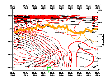
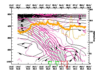
It can be seen at both 06.00 UTC and 12.00 UTC that there is warm advection ahead of the front. At 06.00 UTC the warm advection extends from the surface up to 600 hPa, the maximum being little more than 1 K/12 hours at approximately 900 hPa. The cold advection of the Cold Front is also clearly seen. There are two maxima of cold advection at 06.00 UTC, both situated behind the frontal surface, one at 800 hPa, the other at 500 hPa. The magnitude of the cold advection is about -10 K/12 hours, which is clearly larger, in absolute values, than that of the warm advection. Furthermore there is weak cold advection at upper levels ahead of the Cold Front.
29 May 2000/06.00 UTC - Vertical cross section; black: isentropes (ThetaE), red thin: temperature advection - CA, red thick: temperature advection - WA,
orange thin: IR pixel values, orange thick: WV pixel values
At 12.00 UTC the warm advection covers virtually the whole region in front of the frontal surface, exhibiting two rather distinct maxima, which both are a little over 2 K/12 hours. One is situated at 800 hPa at the position of the Convergence Line, the other situated further to the west along the frontal surface at approximately 650 hPa. The strong cold advection behind the Cold Front does not differ significantly from that seen at 06.00 UTC. The front does not move that much during this period of time. The temperature gradient across the Cold Front, near the surface, is much more pronounced at 12.00 UTC than at 06.00 UTC.
29 May 2000/12.00 UTC - Vertical cross section; black: isentropes (ThetaE), red thin: temperature advection - CA, red thick: temperature advection - WA,
orange thin: IR pixel values, orange thick: WV pixel values
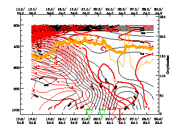
The cross sections reveal that the warmest air is situated immediately ahead of the front at both 06.00 and 12.00 UTC. This very warm air is, in effect, a Warm Conveyor Belt, and its location fits well with that of the Convergence Line. Additionally, an important fact is that the equivalent potential temperature of the air ahead of the Cold Front is even 8 K higher at 12.00 UTC than at 06.00 UTC. Solar radiation is an important contributor here, as the temperature advection at 06.00 UTC is only about 1 K/12 hours. However, the warming of the air near the surface contributes essentially to the destabilisation of the air column ahead of the Cold Front. This is brought out by the fact that equivalent potential temperature is decreasing much more clearly with height at 12.00 UTC than at 06.00 UTC. This indicates larger potential instability. While the equivalent potential temperature field is only slightly unstable at 06.00 UTC, it is clearly unstable up to about 650 hPa at 12.00 UTC. Weak cold advection in the upper levels at 06.00 UTC also contributes to this development.
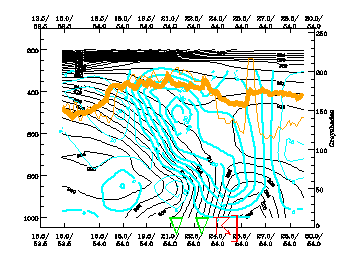
Cross-sections of divergence and omega at 12.00 UTC are presented below. It can be seen that convective development is quite well shown by the model analysis. There is convergence at the position of the Convergence Line reaching up to approximately 800 hPa, the maximum being near the surface. Another maximum of convergence is situated along the frontal surface, further to the west, at 700 hPa, and is clearly a frontal feature. A divergence maximum is seen ahead of the frontal surface at high levels and weak divergence is also seen behind the front at about 800 hPa.
29 May 2000/12.00 UTC - Vertical cross section; black: isentropes (ThetaE), magenta thin: divergence, magenta thick: convergence, orange thin: IR pixel
values, orange thick: WV pixel values
The omega field reflects the convergence field. There is upward motion in a wide area ahead of the frontal surface, exhibiting two maxima; one ahead of the front at 800 hPa and the other along the frontal surface at 500 hPa. Moreover, the upward motion extends through a thick layer, especially at the position of the Convergence Line, where upward motion is seen reaching throughout the troposphere. The magnitude of the upward motion at the convergence line is about -20 hPa/hour, which is a very small value compared to the typical updraft of 1-10 m/s in convective clouds (Puhakka 1995). The reason for this is that the resolution of the model analysis is insufficient to catch the small scale, strong updraft of a developing convective cloud. However, qualitatively, the upwardmotion is represented well.
29 May 2000/12.00 UTC - Vertical cross section; black: isentropes (ThetaE), cyan thick: vertical motion (omega) - upward motion, cyan thin: vertical motion
(omega) - downward motion, orange thin: IR pixel values, orange thick: WV pixel values