29 MAY 2000 - WEATHER EVENTS

by FMI


The main weather events during the day are an increasing number of thunderstorms along the Convergence Line and some precipitation in the region of the Cold Front cloud band. The images below show the weather events in detail, based upon synoptic observations at 12.00, 15.00 and 18.00 UTC. At 12.00 UTC there are only a few thunderstorms reported along the Convergence Line, while there is quite a lot of precipitation in the region of the Cold Front. At 15.00 UTC the situation has changed such that there are many thunderstorms and slightly fewer observations of precipitation alone. By 18.00 UTC, precipitation is again observed more widely, while there are only a few thunderstorms. The thunderstorms are located along a line, exactly at the position of the pre-frontal Convergence Line. Thus the weather events observed are very similar to the typical ones.
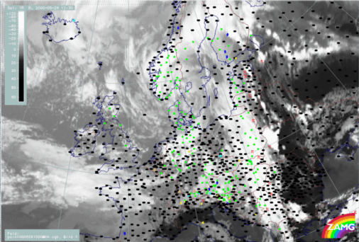
29 May 2000/06.00 UTC - Meteosat IR image; weather events (green: rain and showers, blue: drizzle, cyan: snow, red: thunderstorm with precipitation, purple: freezing rain, orange: hail, black: no actual precipitation or thunderstorm with precipitation)
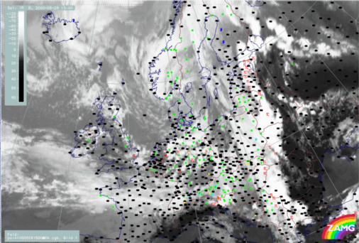
29 May 2000/15.00 UTC - Meteosat IR image; weather events (green: rain and showers, blue: drizzle, cyan: snow, red: thunderstorm with precipitation, purple: freezing rain, orange: hail, black: no actual precipitation or thunderstorm with precipitation)
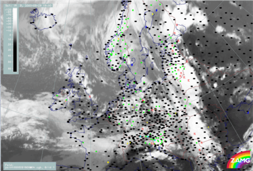
29 May 2000/18.00 UTC - Meteosat IR image; weather events (green: rain and showers, blue: drizzle, cyan: snow, red: thunderstorm with precipitation, purple: freezing rain, orange: hail, black: no actual precipitation or thunderstorm with precipitation)
A map of full synoptic observations at 12.00 UTC is shown below. The converging wind field is clearly seen (the direction of the wind differs by as much as 90 degrees between neighbouring observation stations at the position of the Convergence Line). Furthermore, the very warm and moist air ahead of the Cold Front is also clearly seen. Temperatures reaching almost 30 degrees centigrade and dewpoints exceeding 15 degrees can be observed over quite an extensive clear area ahead of the Cold Front. The air immediately behind the front is substantially cooler, with temperatures of about 15 degrees centigrade.
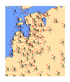
29 May 2000/12.00 UTC - Synoptic observations; black: Surface temperature, red: dewpoint, green: present weather

SUB-MENU OF 29 MAY 2000
SATELLITE IMAGES
CROSS SECTIONS