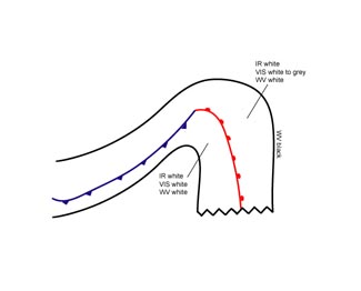
Warm Front Shield - Cloud Structure In Satellite Images
by ZAMG
- The satellite image shows a synoptic scale cloud shield which lies in front of a Cold Front, and comprising the area of the Warm Front and the warm sector.
- In the VIS image the grey shades, in a well developed case, are generally white within the warm sector and near to the surface Warm Front,while the grey shades become gradually more and more grey towards the forward cloud edge (see Warm Front Band).
- In the IR image the grey shades of the cloud shield are usually white indicating cold cloud tops, but very often they show substructures differing from case to case.
- The pixel values in the WV image within the area of the cloud shield are high and bright.
- At the leading edge of the cloud shield the WV image shows, along the jet axis, a sharp gradient from white to black indicating dry air at the cyclonic jet side (see Warm Front Band).
- In contrast to the Warm Front Band,(see Warm Front Band - Cloud structure in satellite image ) the warm sector of the Warm Front Shield is overcast with cloudiness within the ascending Warm Conveyor Belt, which can, in a well developed case, extend through a rather deep layer of the troposphere.
|
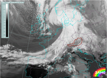
12 February 2005/12.00 UTC - Meteosat 8 IR 10.8 image
|
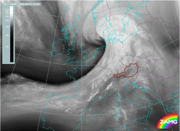
12 February 2005/12.00 UTC - Meteosat 8 WV 6.2 image
|
|
|
|
|
|
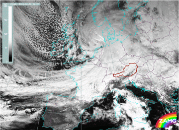
12 February 2005/12.00 UTC - Meteosat 8 VIS 0.6 image
|
- bright grey shades in the centre of the cloud shield in the IR and WV images;
- high albedo values in the VIS image in the centre of the cloud shield and gradually decreasing values to the forward edge;
- the black area in the WV imagery in front of the leading edge of the cloud shield along the cyclonic side of the jet;
- the cloud shield encompasses the warm sector and the Warm Front area, which is in contrast to the band-form of the Warm Front.

