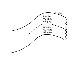
Warm Front Band - Cloud Structure In Satellite Images
by ZAMG
- The satellite image shows an anticyclonically curved synoptic scale cloud band which is connected to a Cold Front cloud band.
- In ideal cases:
- in the VIS image the grey shades are generally white at the rear edge becoming increasingly grey towards the forward edge;
- in the IR image the grey shades of the cloud band are grey to white, where the brighter values appear, in the ideal case, towards the forward and downstream cloud edge.
- In reality:
- very often no continuous cloud band exists but rather several cloud layers with broken cloudiness, or sometimes even only high cloudiness;
- in the IR image several white cloud areas are superimposed on grey lower cloud layers (see Meteorological physical background).
- High, bright WV pixel values can be observed in the area of the frontal cloud band.
- At the leading edge of the cloud band the WV image shows a sharp gradient from white to black indicating dry air along the cyclonic side of the jet.
- In contrast to the Warm Front Shield (see Warm Front Shield), the warm sector of the Warm Front Band is usually cloudless, except in winter and spring time when extended fields of fog and low clouds can exist associated with processes in the lowest layers (see Fog and Stratus ).
|
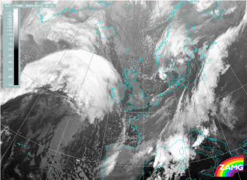
15 September 2004/06.00 UTC - Meteosat 8 IR 10.8 image
|
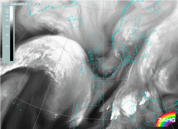
15 September 2004/06.00 UTC - Meteosat 8 WV 6.2 image
|
|
|
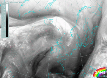
The Warm Front cloud band can be observed over the Atlantic (just east of approximately 25W) extending to Northern Ireland. Several features mentioned above can be observed:
- the gradual increase of cloud top temperatures from the rear to the leading edge (in IR image);
- the distinct leading boundary of the cloud band (in IR and WV images);
- the Dark Stripe (in WV image) along the cyclonic side of the above-mentioned cloud edge;
- the cloudless warm sector.
|
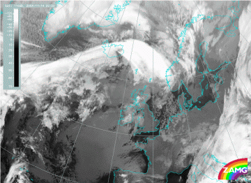
14 November 2004/00.00 UTC - Meteosat 8 IR 10.8 image
|
14 November 2004/06.00 UTC - Meteosat 8 WV 6.2 image
|
|
|
The cloud band of the Warm Front can be located in the IR and WV images from Iceland across the Atlantic towards Norway. In the IR image it consists of several high, i.e. cold, cloud areas and cloud lines superimposed on dark grey, i.e. warmer, cloud tops. Over Iceland the mountains trigger some lee clouds, embedded by the Warm Front Band. In the WV image a broad white band in the area of the Warm Front indicates high water vapour content bounded by Dark Stripes on the northern as well as the southern edges. The northern stripe represents the dry air along the cyclonic side of the jet. The dark grey area extending over Great Britain is an extensive area of Fog and Stratus.

