Wave - Key Parameters
by ZAMG
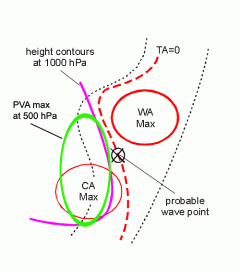
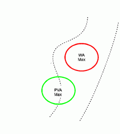
- Warm advection (WA):
The field of temperature advection is characterized by a juxtaposition of a WA maximum within the cloud bulge and a CA maximum in the dry air behind. This indicates the circulation of air masses within the deepening low (see Meteorological physical background ). In reality the WA maximum can be rather weak while usually a pronounced CA maximum exists behind the cloud bulge. The zero line of the temperature advection passes through the bulge and should mark the centre of the Wave. - Positive vorticity advection (PVA):
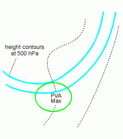
A PVA maximum is superimposed upon the cloud bulge in the higher levels of the troposphere (500 and 300 hPa), indicating the deepening of a low.
Both (WA and PVA) are responsible for the production of the increased cloudiness of the Wave bulge. - Absolute topography at 1000 and 500 hPa:
In the absolute topography at lower levels of the troposphere (for instance at 1000 hPa) a low pressure area can be observed which often manifests itself as a pronounced trough but sometimes already shows a weak closed circulation, intensifying during the life cycle. In upper levels, for instance at 500 hPa, a large scale trough can usually be observed with cloudiness in the south-western stream. - Isentropic potential vorticity (IPV):
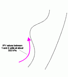
According to Hoskins (1986) anomalies of IPV representing very dry stratospheric air can be regarded as being connected with cyclogenesis. The approach of an IPV anomaly at higher levels in the direction of a low level baroclinic zone may cause cyclogenesis. From present knowledge the Waves described in this chapter are not a typical example for such a development, but very often an anomaly develops upstream on the rear side of the Wave at higher levels around approximately 300 hPa; this is accompanied by the development of a black area in the WV image.
|
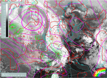
04 July 2005/12.00 UTC - Meteosat 8 IR 10.8 image; green: equivalent thickness 500/850 hPa; blue: thermal front
parameter 500/850 hPa; red: temperature advection 700 hPa
|
|
|
|
|
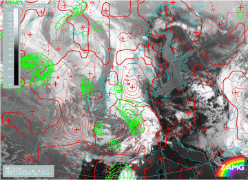
04 July 2005/12.00 UTC - Meteosat 8 IR 10.8 image; red: temperature advection 500/1000 hPa, green: positive
vorticity advection 500 hPa
|
|
|
|
|
04 July 2005/12.00 UTC - Meteosat 8 IR 10.8 image; cyan: height contours 500 hPa, green: positive vorticity
advection 500 hPa
|
|
|
|
|
04 July 2005/12.00 UTC - Meteosat 8 IR 10.8 image; magenta: geopotential height at 100 hPa, red: temperature
advection 500/1000 hPa, green: positive vorticity advection 500 hPa
|
|
|

|
|
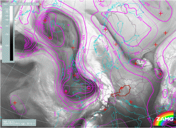
04 July 2005/12.00 UTC - Meteosat 8 WV 6.2 image; magenta: height of isentropic potential vorticity = 1
|
|
|
|
The last image is a Meteosat 8 WV 6.2 image which contains the height of the potential vorticity = 1. A maximum of stratospheric air has protruded downward as far as 550 hPa on the rear of the Wave. This is also the location where at this stage the cloud dissolvement is taking place.


