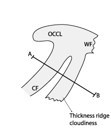
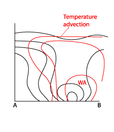
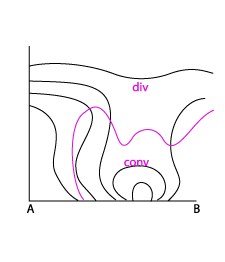
Thickness Ridge Cloudiness - Typical Appearance In Vertical Cross Sections
by ZAMG and DHMZ
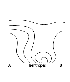
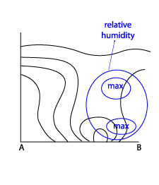
- Isentropes:
A vertical cross section taken across the Cold Front - Thickness Ridge Cloudiness - Warm Front shows the typical frontal gradient of isentropes connected to the Cold Front and Warm Front. In between a maximum of isentropes is observed in the area of the Thickness Ridge Cloudiness. This maximum is an indication of a tongue of warm air. It consists of a maximum of closed isolines in the lower layers indicating unstable conditions. The height of the maximum differs according to the seasons and can be very extreme in summer. The upper part over the maximum has some similarities with an "isentropic trough" usually associated with an Occlusion, but corresponding to a rising warm conveyor belt which is superimposed upon the unstable zone. Depending on the season the layer of the warm conveyor belt can be rather deep. - Temperature advection:
As the Thickness Ridge Cloudiness appears in front of a Cold Front, it generally exists within positive temperature advection (WA) at all levels This is, in effect, the dominating warm conveyor belt. - Relative humidity:
Although there is a maximum of humidity at the low levels, the rising air of the warm conveyor belt leads to a secondary relative humidity maximum associated with Thickness Ridge Cloudiness in middle and upper levels. - Divergence:
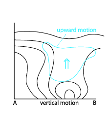
Although there is a distinct convergence maximum in lower levels, there is a broad zone of convergence representing the warm conveyor belt stream at middle and higher levels. - Vertical motion (Omega):
Convergence in lower levels leads to a distinct maximum of upward motion in middle and even higher levels.
|
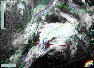
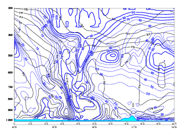
11 April 2008/06.00 UTC - Meteosat 9 IR10.8 image; blue: thermal front parameter (TFP), green: equivalent thickness 500/850 hPa; position of
vertical cross section indicated
|
|
|
|
|
|
|
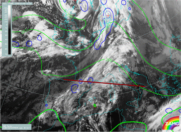
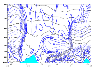
09 January 2008/12.00 UTC - Meteosat 9 IR10.8 image; blue: thermal front parameter (TFP) 500/850 hPa, green: equivalent thickness 500/850 hPa;
position of vertical cross section indicated
|
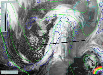
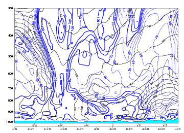
13 January 2008/06.00 UTC - Meteosat 9 IR10.8 image; blue: thermal front parameter (TFP) 500/850 hPa, green: equivalent thickness 500/850 hPa;
position of vertical cross section indicated
|
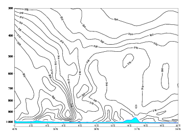
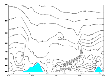
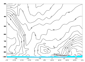
Isentropes, equivalent potential temperature
|
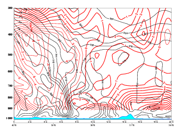
11 April 2008/06.00 UTC - Vertical cross section; black: isentropes (ThetaE)
|
|
|
|
|
09 January 2008/12.00 UTC - Vertical cross section; black: isentropes (ThetaE)
|
|
|
|
13 January 2008/06.00 UTC - Vertical cross section; black: isentropes (ThetaE)
|
|
|
Temperature advection
|
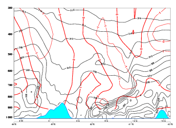
11 April 2008/06.00 UTC - Vertical cross section; black: isentropes (ThetaE), red thin: temperature advection - CA, red thick:
temperature advection - WA
|
|
|
|
|
09 January 2008/12.00 UTC - Vertical cross section; black: isentropes (ThetaE), red thin: temperature advection - CA, red thick:
temperature advection - WA
|
|
|
|
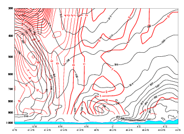
13 January 2008/06.00 UTC - Vertical cross section; black: isentropes (ThetaE), red thin: temperature advection - CA, red thick:
temperature advection - WA
|
|
|
Relative humidity
|
11 April 2008/06.00 UTC - Vertical cross section; black: isentropes (ThetaE), blue: relative humidity
|
|
|
|
|
09 January 2008/12.00 UTC - Vertical cross section; black: isentropes (ThetaE), blue: relative humidity
|
|
|
|
13 January 2008/06.00 UTC - Vertical cross section; black: isentropes (ThetaE), blue: relative humidity
|
|
|
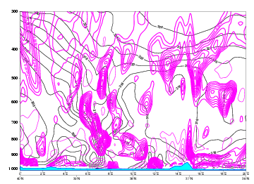
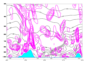
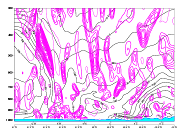
Divergence
|
11 April 2008/06.00 UTC - Vertical cross section; black: isentropes (ThetaE), magenta thick: convergence, magenta thin: divergence
|
|
|
|
|
09 January 2008/12.00 UTC - Vertical cross section; black: isentropes (ThetaE), magenta thick: convergence, magenta thin: divergence
|
|
|
|
13 January 2008/06.00 UTC - Vertical cross section; black: isentropes (ThetaE), magenta thick: convergence, magenta thin: divergence
|
|
|
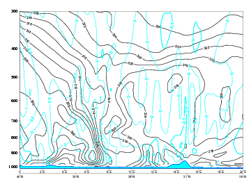
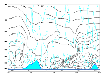
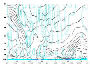
Vertical motion (Omega)
|
11 April 2008/06.00 UTC - Vertical cross section; black: isentropes (ThetaE), cyan thick: vertical motion (omega) - upward motion, cyan thin:
vertical motion (omega) - downward motion
|
|
|
|
|
09 January 2008/12.00 UTC - Vertical cross section; black: isentropes (ThetaE), cyan thick: vertical motion (omega) - upward motion, cyan thin:
vertical motion (omega) - downward motion
|
|
|
|
13 January 2008/06.00 UTC - Vertical cross section; black: isentropes (ThetaE), cyan thick: vertical motion (omega) - upward motion, cyan thin:
vertical motion (omega) - downward motion
|
|
|


