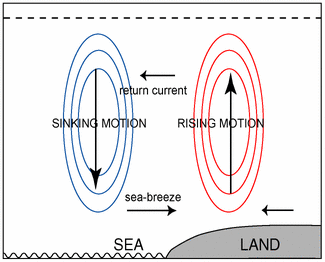
Sea-breeze - Typical Appearance In Vertical Cross Sections
by FMI and KNMI
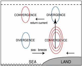
- Low-level convergence:
At the boundary of the Sea-Breeze low-level convergence exists, but coarse model resolution may not always show this properly. - Vertical motion:
Rising motion enhanced by convergence at the Sea-breeze boundary
Low-level convergence
|
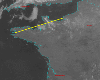
22 April 2009/14.00 UTC - Meteosat HRV image; position of vertical cross section indicated
|
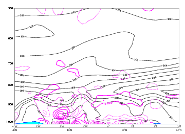
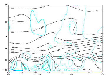
22 April 2009/12.00 UTC - Vertical cross section; magenta dashed: divergence, magenta solid: convergence
|
|
|
|
|
|
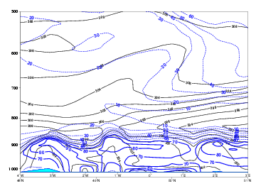
22 April 2009/12.00 UTC - Vertical Cross section; blue: relative humidity
|
From the theory convergence is to be expected in a See-Breeze situation over land and divergence over sea. Normandy has coordinates around 01.5degr W. Convergence is forecast in that area with divergence above. To the east, over the Seine - Bay and west, over the Channel Islands, divergence is forecast with convergence aloft.
With this pattern in mind upward motions have to be present over Normandy with downward motion to the east and west. This pattern is well forecast in the images below with on the left side the expected and theoretical scheme of vertical motion and on the right side the calculated values of up - and downdrafts. The satellite image clearly shows the convective clouds over Normandy and the cloud free area's to the west and east.
Although not a key parameter on its self a vertical cross section on Relative Humidity is plotted on the right side of the Div./Conv - scheme. with RH = 80% or more over Normandy.
Low-level convergence
|
22 April 2009/12.00 UTC - Vertical cross section; cyan solid: vertical motion (omega) - upward motion, cyan dashed: vertical motion (omega) -
downward motion
|
|
|
|


