Sea-breeze - Weather Events
by FMI and KNMI
| Parameter | Description |
| Precipitation (incl. thunder) |
|
| Temperature |
|
| Wind (incl. gusts) |
|
| Other relevant information |
|
|
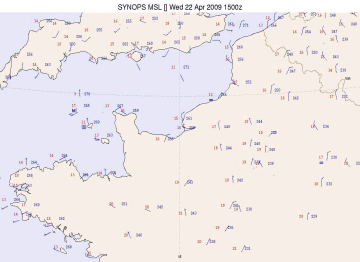
22 April 2009/15.00 UTC - Synoptic plot of Sea-Breeze over Normandy, France
|
|
|
|
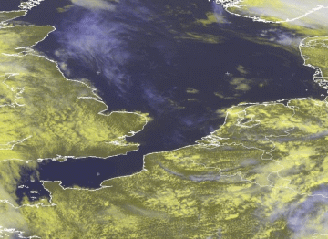
A second example is the situation of the 3rd of August 2009 over The Netherlands, some images are already available in the chapter cloud structures.
|
03 August 2009/12.00 UTC - Meteosat 9 image HRV/IR 10.8 image
|
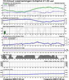
03 August 2009/12.00 UTC - Meteorogram Schiphol/Amsterdam
|
|
|
The meteorogram consists of 24 hours graphs of different meteorological variables, measured at the surface and averaged over a period of 10 minutes. The variables are, from top to bottom : temperature and dew point, humidity (RH), precipitation, wind speed and wind direction (blue arrows), cloudiness, visibility (below 1000m only) and pressure.
In the meteorogram, above right, the recorded values at the aerodrome Amsterdam Airport Schiphol, which is located about 15km to the east of the Dutch west coast, are depicted. The meteorogram starts at the 2nd of August, 21.20 UTC and last untill the 3rd of August 21.20 UTC. Notice the small drop in temperature between 13.00 and 14.00 UTC at the time of the veering surface wind, together with the small increase in RH: the passing of the Sea-Breeze front.
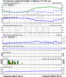
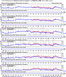
Down below a meteorogram of a KNMI observation site at Cabauw (located in the central part of The Netherlands at a distance of about 55km to the east of the coastline). Left the recorded surface observations (as in the previous meteorogram), right the recorded wind observations (speed, gust in red and wind direction, the blue arrows) at different heights in the 200m tower. The different heights are 10m , 20m, 40m, 80m, 140m and 200m. The passing of the Sea-Breeze front is nicely depicted by a remarkable veering of the wind almost at the same time at all levels.
|
03 August 2009 - Meteorogram Cabauw 022120 - 032120 UTC SFC Observations
|
03 August 2009 - Meteorogram Cabauw 022120 - 032120 UTC Wind observations 200m tower
|
|
|


