Rapid Cyclogenesis - Key Parameters
by KNMI and ZAMG
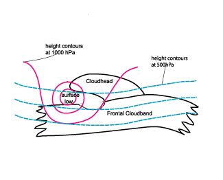
- Height contours at 1000 hPa:
During the initial stages of development the absolute topography shows a continuously deepening trough. The mature stage is characterized by a surface low situated in the cloudless area of the dry tongue between the cloudiness of the Cold Front and the cloud head, the latter being situated to the rear side of the low. The height contours at 500 are perpendicular to the height contours at 1000 hPa indicating the cyclogenesis in the developing stage of RaCy. - Temperature advection (TA):
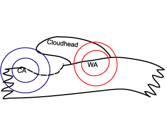
The field of temperature advection shows a very distinct situation for a wave: a maximum of WA within the cloud head and the relevant parts in front, and CA behind. This pronounced WA/CA dipole is a sign of the ongoing cyclogenesis. - Isotachs at 300 hPa:
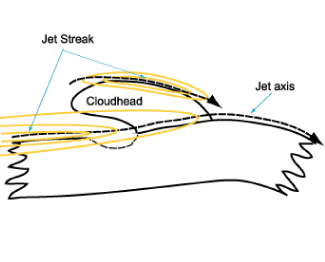
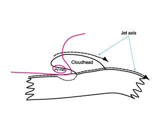
The isotachs at 300 hPa show a pronounced jet stream along the rear edge of the frontal cloud band. The cloud head can often be found within the left exit region of a jet streak situated downstream of the low. In the mature stage a second jetstreak forms at the polar side of the cloud head. - Vorticity advection at 500 and 300 hPa (PVA/NVA):
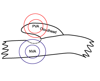
The field of vorticity advection shows a pronounced PVA maximum at 500 as well as at 300 hPa mostly situated within the area of the cloud head. The maximum can be found in the area of the left exit of the main jet streak and near the right entrance of the second jet streak. - Potential vorticity (PV):
The potential vorticity shows an anomaly (values between one and two units) along the rear cloud edge of the cold front. The anomaly, which separates the tropospheric from the stratospheric air, can be found in lower layers than for wave cases, 400 hPa being an approximate height in the initial stage.
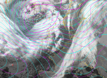
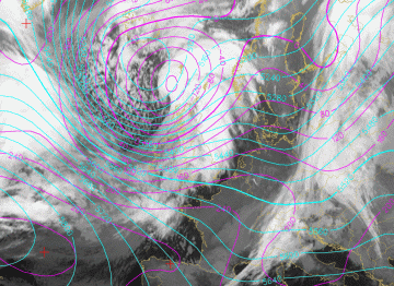
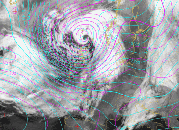
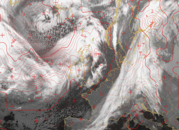
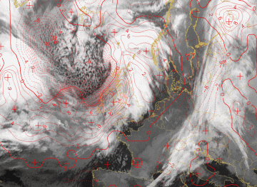
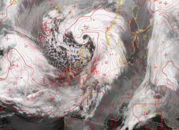
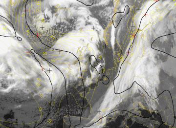
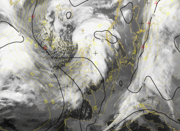
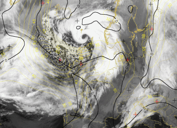
The images from 30 and 31 January 2008 show three time steps in the live cycle of Rapid Cyclogenesis around 60 degrees North and 10 degrees West at 18.00 UTC, 00.00 UTC and 0600 UTC. At 00.00 UTC the system is in a developing stage and by 06.00 UTC the system has already reached the mature phase.
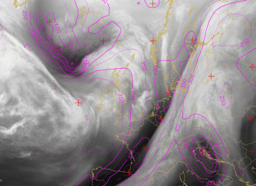
Absolute topography at 1000 hPa
|
30 January 2008/18.00 UTC - Meteosat IR10.8 image; magenta: height contours 1000 hPa, cyan: height contours 500 hPa
|
|
|
|
|
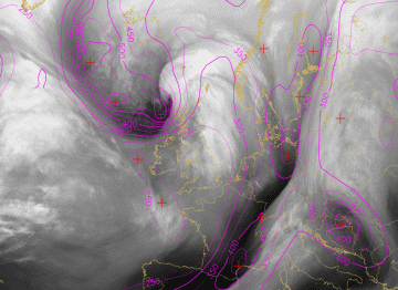
31 January 2008/00.00 UTC - Meteosat IR10.8 image; magenta: height contours 1000 hPa, cyan: height contours 500 hPa
|
|
|
|
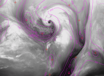
31 January 2008/06.00 UTC - Meteosat IR10.8 image; magenta: height contours 1000 hPa, cyan: height contours 500 hPa
|
|
|
Temperature advection (TA)
|
30 January 2008/18.00 UTC - Meteosat IR10.8 image; red: temperature advection 700 hPa; solid red line WA; dashed lined CA
|
|
|
|
|
31 January 2008/00.00 UTC - Meteosat IR10.8 image; red: temperature advection 700 hPa; solid red line WA; dashed lined CA
|
|
|
|
31 January 2008/06.00 UTC - Meteosat IR10.8 image; red: temperature advection 700 hPa; solid red line WA; dashed lined CA
|
|
|
Isotachs at 300 hPa
|
30 January 2008/18.00 UTC - Meteosat IR10.8 image; yellow: isotachs 300 hPa, black: zero line of shear vorticity 300 hPa
|
|
|
|
|
31 January 2008/00.00 UTC - Meteosat IR10.8 image; yellow: isotachs 300 hPa, black: zero line of shear vorticity 300 hPa
|
|
|
|
31 January 2008/06.00 UTC - Meteosat IR10.8 image; yellow: isotachs 300 hPa, black: zero line of shear vorticity 300 hPa
|
|
|
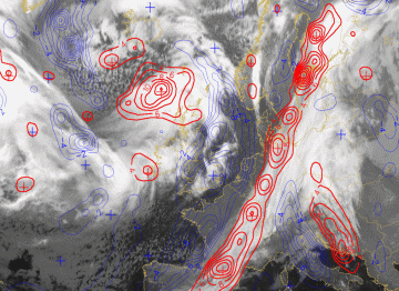
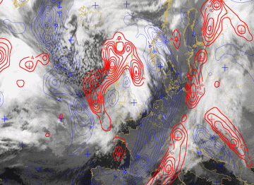
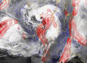
Vorticity advection at 500 and 300 hPa (PVA/NVA)
|
30 January 2008/18.00 UTC - Meteosat IR10.8 image; red: positive vorticity advection (PVA) 300 hPa, blue: negative vorticity advection (NVA) 300
hPa, black: zero line of positive vorticity advection (PVA) 300 hPa
|
|
|
|
|
31 January 2008/00.00 UTC - Meteosat IR10.8 image; red: positive vorticity advection (PVA) 300 hPa, blue: negative vorticity advection (NVA) 300
hPa, black: zero line of positive vorticity advection (PVA) 300 hPa
|
|
|
|
31 January 2008/06.00 UTC - Meteosat IR10.8 image; red: positive vorticity advection (PVA) 300 hPa, blue: negative vorticity advection (NVA) 300
hPa, black: zero line of positive vorticity advection (PVA) 300 hPa
|
|
|
Potential Vorticity (PV)
|
30 January 2008/18.00 UTC - Meteosat WV6.2 image; magenta: height of PV = 1
|
|
|
|
|
31 January 2008/00.00 UTC - Meteosat WV6.2 image; magenta: height of PV = 1
|
|
|
|
31 January 2008/06.00 UTC - Meteosat WV6.2 image; magenta: height of PV = 1
|
|
|


