Rapid Cyclogenesis - Meteorological Physical Background
by KNMI and ZAMG
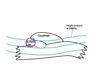
- Emerging Cloud Head
- Cyclogenesis within the Left Exit Region of a jet streak
- Comma Cloud
However, within this manual and the satellite report, the conceptual model of the so-called Emerging Cloud Head is associated with Rapid Cyclogenesis and will therefore now be described in more detail.
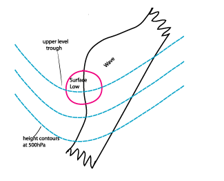
While classical cyclogenesis through Wave development (see
Wave
) is often slow and the Wave bulge dissolves after some time or produces a spiral after some days, Rapid Cyclogenesis usually leads to a fast development of a cloud spiral.
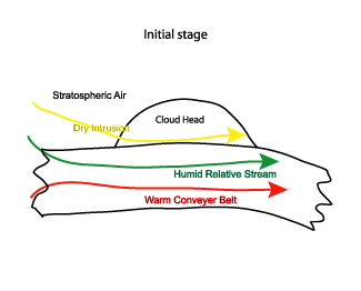
Within the polar front theory no separation between Wave development and Rapid Cyclogenesis can be found, and the distribution of the key parameters is very similar to, and even more distinct than, that for Wave development (see Key parameters). In addition to the Wave model, the jet streak and surrounding sinking dry air play key roles. The emerging cloud head in the initial stage usually appears in the left exit region of a jet streak. The jet streak is parallel to the initial cloud band with dry stratospheric air approaching downstream into the cloud head. This is seen as the typical black stripe in the WV imagery as well as the field of PV showing values higher than one PV units. While in the case of Wave development stratospheric air (if present at all) does not reach down to levels lower than 300 hPa, in the case of Rapid Cyclogenesis stratospheric air is a key feature and protrudes much further downward (down to approximately 500 hPa or even lower).
The dry sinking stratospheric air has a significant impact upon the cloud configuration. As it dissolves the cloudiness between the front and the cloud head, a spiral structure as well as the typical V - pattern develop. This is closely connected with special characteristics of relative streams.
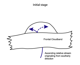
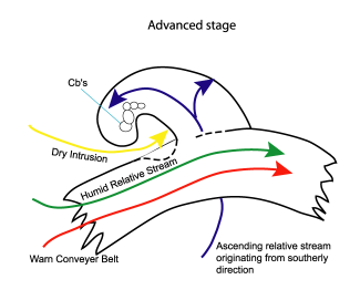
There are several conveyor belts involved belonging to the different cloud systems. The cloudiness of the main frontal zone is produced by a typical Warm Conveyor Belt together with a humid relative stream from behind (see Cold Front ) while the dry stream from behind appears behind the poleward edge of the frontal cloud band. This is the dry stream containing stratospheric air described above. The cloud head is formed within the lower and mid-levels of the troposphere by a rapidly ascending conveyor belt advecting warm and moist air from lower latitudes beneath the Warm Conveyor Belt of the frontal zone. After crossing this Cold Front zone the conveyor belt often splits into a westward and an eastward flowing branch. This splitting of the relative flow leads to the convex-formed cloud edge at the pole ward side of the cloud head. This is comparable to the Occlusion process in Wave development (see Wave and Occlusion: Warm Conveyor Belt Type ).
As the advected air of the dry intrusion originates from the lower levels of the stratosphere, this flow is characterized by high values of potential vorticity. In the area where the dry intrusion is superimposed on the ascending conveyor belt from southern directions a potentially unstable stratification of the troposphere develops in which thunderstorms frequently occur (see Cloud structure in satellite images and Weather events).
|
|
|
|
|
|
|
|
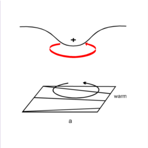
The assumption for the figures above is that that an upper-level, positive PV-anomaly is being advected over a zone of strong, low-level equatorward temperature gradient describes a situation where an originally small-scale upper level trough moves over a zonally oriented surface Cold Front. The left figure (a) shows such a situation with the solid + sign indicating the upper level PV-anomaly.
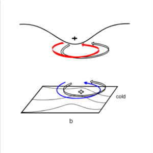
The thick solid arrow around the PV maximum indicates the cyclonic rotation. This rotation is induced at lower levels of the baroclinic zone as shown by the thin solid circulation arrow. This low level circulation causes warm advection ahead leading to a low level positive temperature anomaly indicated by the open + sign in the right figure (b). This temperature anomaly is associated with a cyclonic vortex which is marked by the open arrow at low levels. In turn, this circulation has a positive feedback to the upper troposphere, shown by an open circulation arrow at higher levels.
In parallel a second process is taking place: The induced low level vortex results in a strong equatorward wind component under the upper level PV anomaly. This southward component also influences the higher levels and leads to an equatorward advection of the upper level PV-anomaly which in turn intensifies the upper level Wave.
Within this increased flow higher PV values to the west of the PV-anomaly are advected southward and lower PV values to the east of the PV-anomaly are advected northward. As a consequence of the latter process, the eastward movement of the PV-anomaly is decreased. Hence, the interaction between low and upper level circulations and the already ongoing cyclogenesis process will strengthen.
More information on this theory can be found in the introduction chapter "Parameters for the diagnosis of cloudiness - PV" (see Additional parameters and helpful tools for the diagnosis of cloudiness- Potential Vorticity ).
|
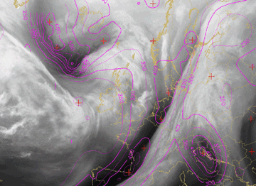
30 January 2008/12.00 UTC - Meteosat 9 WV6.2 image; height of 1 units potential vorticity (in hPa); magenta: potential vorticity
|
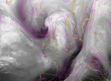
30 January 2008/18.00 UTC - Meteosat 9 WV6.2 image; height of 1 units potential vorticity (in hPa); magenta potential vorticity
|
|
|
|
|
|
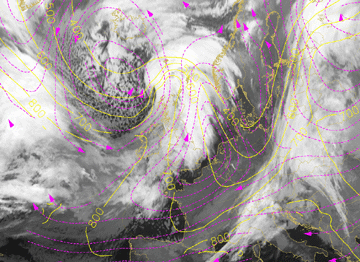
31 January 2008/00.00 UTC - Meteosat 9 WV6.2 image; height of 1 units potential vorticity (in hPa); magenta potential vorticity
|
The image at 12.00 UTC (top left image) shows the initial stage of the development of a cloud head. The developing cloud head can be observed southwest of Iceland. To its rear an intensive PV anomaly can be seen with high a gradient parallel to the frontal cloud band. The (dynamical) tropopause, here indicated with the height of 1 units PV, has lowered to a minimum 500 hPa in the cold air to the rear of the frontal cloud band. During the next 12 hours this tropopause minimum, or PV - trough, representing stratospheric air approaches and overruns the developing cloud spiral of the Rapid Cyclogenesis.
Comparing again Wave development (see Wave ) and Rapid Cyclogenesis, a main difference can be found in the orientation of the relative stream forming the cloud head, or cloud bulge. It is similar to a Warm Conveyor Belt in the case of the Wave turning to east/north-eastern direction, but quite opposite in the case of Rapid Cyclogenesis turning to west/south-western directions. There are some differences between the two models, which can lead to this different behaviour:
- In the case of Rapid Cyclogenesis, two frontal zones (or at least a very broad one) exist which cause the rising conveyor belt to reach the rear side of the surface low. This may result, together with the upper stream, in a south-westward split.
- In the case of a Wave, the relative stream remains on the leading edge of the surface low, which may, together with the upper level stream, lead to a north-eastward split.
|
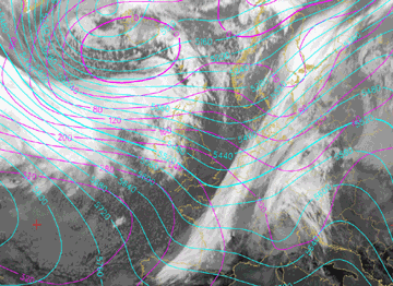
30 January 2008 12.00 UTC - Meteosat 9 IR10.8 image; Magenta: height 1000 hPa, Cyan: height 500 hPa
|
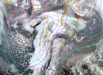
03 February 2008 06.00 UTC - Meteosat 9 IR10.8 image; Magenta: height 1000 hPa, Cyan: height 500 hPa
|
|
|
|
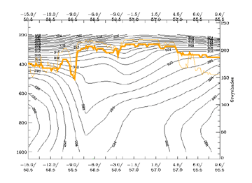
31 January 2008/00.00 UTC - Vertical cross section; black: isentropes (ThetaE), red: temperature advection, orange: WV pixel values
|
31 January 2008/00.00 UTC - Meteosat 9 IR10.8 image; magenta: relative streams 292K - system velocity: 278° 16 m/s, yellow: isobars 296K,
magenta: relative streams, position of vertical cross section indicated
|
|
|
Within, and in front of, the frontal zone the relative stream is rising towards the cloud head from below 700 hPa up to above 400 hPa. Behind the frontal zone and within the dark dry area a relative stream comes from areas with high PV values, representing stratospheric air descending to about 600 hPa in the dry intrusion.


