Rapid Cyclogenesis - Cloud Structure In Satellite Images
by KNMI and ZAMG
Appearance in METEOSAT SECOND GENERATION imagery
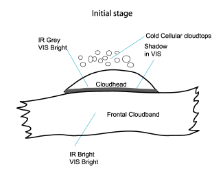
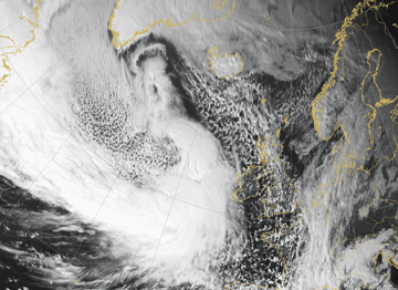
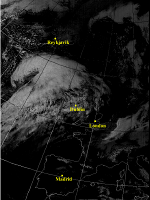
IR10.8 imagery:- During the initial stages of Rapid Cyclogenesis cloudiness with warmer cloud tops can be seen forming an increasingly dense shield with fibrous
edges.
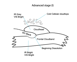
This cloudiness develops on the pole ward side of usually west-east oriented frontal cloud bands. The developing cloud head varies between grey and light grey, mostly with higher tops on the pole ward side. - Advection of dry sinking air originating from the lower levels of the stratosphere at the cyclonic side of a jet stream is advected downstream which leads to cloud dissipation between the cloud band of the Cold Front and the cloud head, thereby creating a V - structure (often also called a dry tongue).
- Due to the potentially unstable stratification of the troposphere (see Meteorological physical background) the inner edge of the cloud head is often characterized by convective cells seen as white spots.
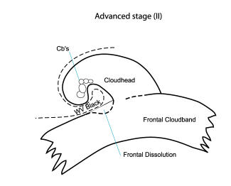
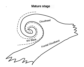
- During the maturing stages the cloud head grows to a cyclonically curved cloud band with a broad dark area between the spiral and the frontal cloud band; additionally, the rear part of the frontal cloudiness frequently dissolves as a consequence of sinking dry air.
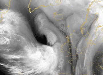
WV6.2 imagery:
- As the cloud head becomes more distinct the typical V - pattern, a black stripe, is formed caused by the advection of dry sinking air originating from the lower levels of the stratosphere along the cyclonic side of a jet stream.
- During the mature stage the cloud head grows into a cyclonically curved cloud band with a broad black area between the spiral and the frontal cloud band.
- Often a further Dark Stripe is present along the pole ward side of the cloud head, indicating a second jet streak.
VIS0.6 imagery:
- During the initial stages the cloud head forms an increasingly dense shield with fibrous edges and develops on the pole ward edge of the frontal cloud band. This cloudiness is characterized by high pixel values (white) with distinct shadows between the different high cloud systems.
Airmass RGB imagery:
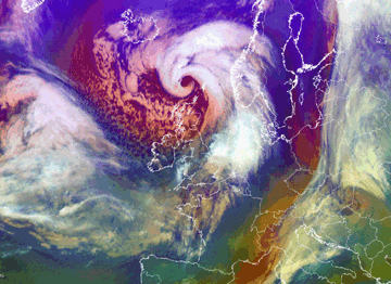
- The Airmass-RGB is an artificial composite consisting of the WV 6.2 - WV 7.3 brightness temperature difference (BTD), on red, the IR 9.7 - IR 10.8 BTD on green and the WV 6.2 channel on blue. Typical features seen on the Airmass RGBs include dry intrusions, deformation zones and jet streaks. Especially the stratospheric air which is protruding down in the cold air behind the frontal zone therefore appears as a reddish colour.
|
|
|
|
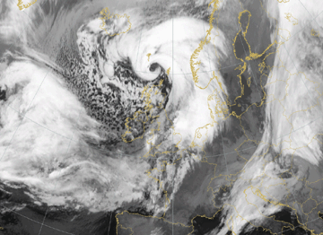
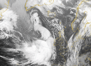
- The case of 31 January 2008 shows a typical rapid development into a pronounced cloud spiral;
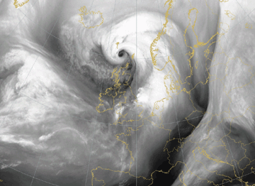
- The case of 09 March 2008 shows the dissipation of frontal cloudiness by dry stratospheric air;
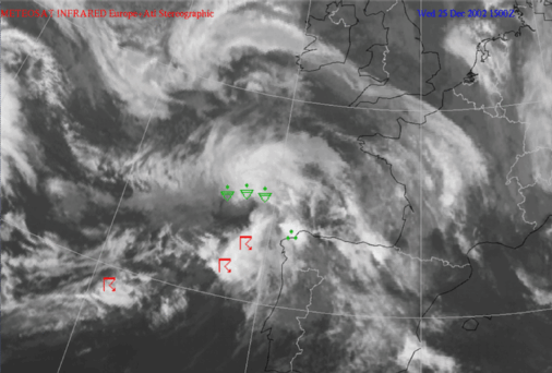
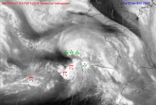
- The case of 25 December 2002 is a good example of convective development in the area of the V - pattern.
|
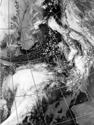
31 January 2008/06.00 UTC - Meteosat 9 IR10.8 image
|
31 January 2008/06.00 UTC - Meteosat 9 WV6.2 image
|
|
|
31 January 2008/06.00 UTC - Meteosat 9 Airmass RGB image
|
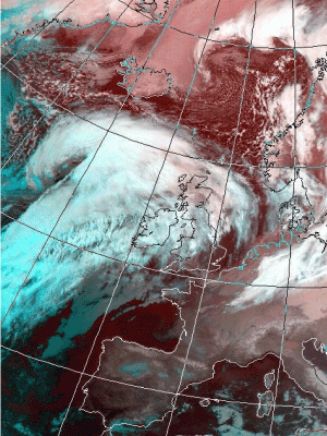
09 March 2008/15.00 UTC - Meteosat 9 IR10.8 image
|
09 March 2008/15.00 UTC - Meteosat 9 VIS0.6 image
|
|
|
|

|
|
09 March 2008/15.00 UTC - Meteosat 9 WV6.2 image
|
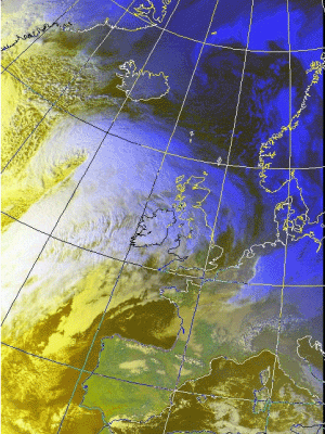
09 March 2008/15.00 UTC - Meteosat 9 Airmass RGB image
|
|
25 December 2002/15 UTC - Meteosat IR image
|
25 December 2002/15 UTC - Meteosat WV image
|
|
|
Appearance in AVHRR imagery
- AVHRR images (below right and third row left) show more detail of the cloud structures when compared to Meteosat images.
- A disadvantage is the lack of water vapour information.
- Pronounced substructures (in all channels) can be seen near the cyclonic and the anticyclonic regions.
- RGB-combination of channels (below left; second row) provides a quick overview of thin or thick, layered, low, middle or high cloudiness.
- Quite often low clouds form under the dry air intrusion, seen as a dark red (night) or yellow (day) area in RGB124.
- Image manipulation (e.g. subtraction with tresholding; third row right) helps to highlight the cloud pattern and some physical features.
Rapid Cyclogenesis over the Atlantic Ocean (approx. 53N/27W)
|
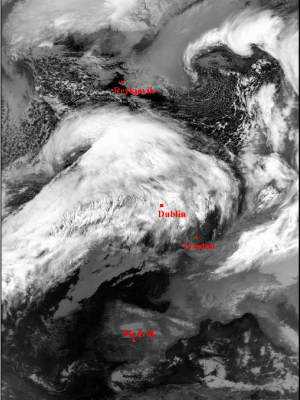
25 November 1999/05.32 UTC - NOAA RGB image (channel 3, 4 and 5)
|
25 November 1999/05.32 UTC - NOAA CH5 image
|
|
|
Rapid Cyclogenesis over the Atlantic Ocean (approx. 57N/22W)
|
25 November 1999/15.27 UTC - NOAA RGB image (channel 3, 4 and 5)
|
25 November 1999/15.27 UTC - NOAA RGB image (channel 1, 2 and 4)
|

|
|
Rapid Cyclogenesis over the Atlantic Ocean (approx. 57N/28W)
|
25 November 1999/15.27 UTC - NOAA CH5 image
|
25 November 1999/15.27 UTC - NOAA CH1 minus CH3B- image
|
|
|

