Rapid Cyclogenesis - Typical Appearance In Vertical Cross Sections
by KNMI and ZAMG
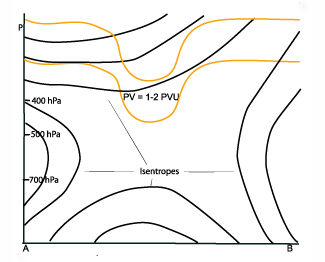
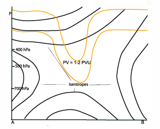
- Potential vorticity (PV):
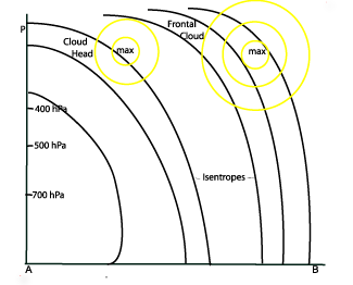
Potential vorticity show an anomaly protruding deep into the atmosphere in, or to the rear of the zone of the highest gradient of the isentropes of the Cold Front. This lowering of the so-called dynamical tropopause (1 - 2 PV Units) is already clearly seen in the initial stage, where the tropopause height sinks below 400 hPa. In mature stages the tropopause is often below 500 hPa and in extreme cases below 700 hPa. - Vorticity advection (PVA/NVA):
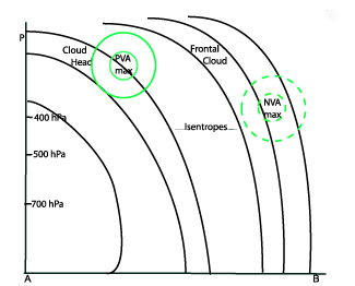
The field of vorticity advection shows a pronounced PVA maximum at upper levels, mostly situated within the area of the cloud head and a NVA max on the other side of the dry tongue in the gradient zone of the Cold Front. Both correlate well with the left and right exit regions of the dominating jet streak. - Temperature advection (TA):
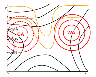
The field of temperature advection shows a very distinct situation similar to, but more pronounced than, a Wave: There is a maximum of WA within and in front of the cloud head, and CA directly behind it. - Isotachs:
The isotachs show a pronounced jet stream along the rear edge of the frontal gradient of the Cold Front. The cloud head can often be found within the left exit region of a jet streak situated downstream of the low. A maximum of the isotachs is often present at the pole - ward side of the cloud head. - Relative Humidity:
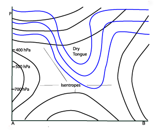
Within the dry tongue low values of relative humidity can be found to relatively low levels in the atmosphere.
The images from 31 January 2008 show three time steps in the live cycle of Rapid Cyclogenesis at 18.00 UTC, 00.00 UTC and 06.00 UTC.
The cross sections are drawn though the dry intrusion. All fields are close to the schematic representing an ideal situation. The most indicative
examples from the three time steps are shown.
|
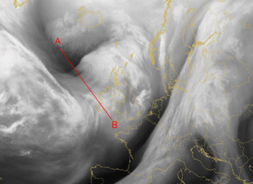
30 January 2008/18.00 UTC - Meteosat 9 WV6.2 image; position of vertical cross section indicated
|
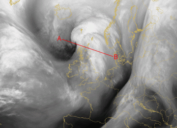
31 January 2008/00.00 UTC - Meteosat 9 WV6.2 image; position of vertical cross section indicated
|
|
|
|
|
|
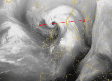
31 January 2008/06.00 UTC - Meteosat 9 WV6.2 image; position of vertical cross section indicated
|
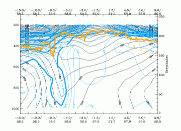
Potential Vorticity (PV)
|
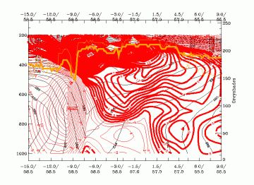
30 January 2008/18.00 UTC - Vertical cross section; black:isentropes (ThetaE), green: potential vorticity, orange thin: IR pixel values; orange
thick: WV pixel values
|
|
|

|
|
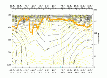
31 January 2008/00.00 UTC - Vertical cross section; black:isentropes (ThetaE), green: potential vorticity, orange thin: IR pixel values; orange
thick: WV pixel values
|
|
|
|
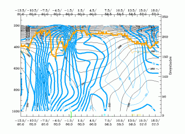
Vorticity advection (PVA/NVA)
|
31 January 2008/06.00 UTC - Vertical cross section; black:isentropes (ThetaE), green: vorticity advection, orange thin: IR pixel values; orange
thick: WV pixel values
|
|
|
|
Temperature advection (TA)
|
31 January 2008/00.00 UTC - Vertical cross section; black:isentropes (ThetaE), red: temperature advection, orange thin: IR pixel values; orange
thick: WV pixel values
|
|
|
|
Isotachs
|
31 January 2008/06.00 UTC - Vertical cross section; black:isentropes (ThetaE), yellow: Isotachs, orange thin: IR pixel values; orange thick: WV
pixel values
|
|
|
|
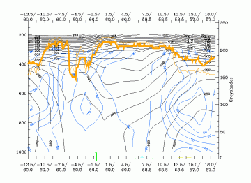
Relative Humidity
|
31 January 2008/06.00 UTC - Vertical cross section; black:isentropes (ThetaE), blue: relative humidity, orange thin: IR pixel values; orange
thick: WV pixel values
|
|
|
|


