Orographic Effects on Frontal Cloud - Meteorological Physical Background
by ZAMG and DHMZ
Front Delay
Although the impact of orography on the motion of fronts has been recognized quite early (Bjerknes and Solberg, 1926) it is only recently that major research efforts have been directed towards observing and understanding the behaviour of fronts near mountains. Some observations and model simulations show that a front passing the mountain chain will be strongly retarded:- if the front is shallow
- if the temperature difference across the front is large
- if the wind velocity normal to the front is small
- if the atmosphere is very stably stratified.
Also, the relative angle of incidence of the front to the elongated mountain is important. Front Delay occurs in cases where there is a long frontal cloud band which is orientated normal or almost normal to a major mountain chain. In the Alpine region this is the common north-south and northeast-southwest orientation of fronts. Moreover, it is observed that the deformation occurs more often if the front approaches the Alps from the west than if it comes from the northwest.
There was an attempt to find similar substructures in fronts passing the Scandinavian Mountains but none was found. Possible reasons why the Scandinavian mountains do not show Front Delay are that:
- they are not so high
- they have a different orientation (in relation to approaching fronts)
|
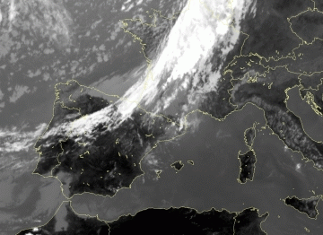
01 September 2009/11.00 UTC - Meteosat 8 IR image
|
|
|
If air is being advected towards an obstacle there are two possibilities: either going around or going above. Which possibility dominates depends on wind speed and stratification: low wind speeds inhibit ascent, as does stable stratification. In the cases investigated in this study low wind speeds in lower levels were found, especially at the leading edge of the frontal cloud band. So the cloud band is retarded where it comes into contact with the mountain ridge. LAM fields show that there is flow around an obstacle. The stratification is also stable (but without inversions). The cloud band therefore undergoes deformation and becomes hook-like in appearance.
Clouds are displaced slower in the mountainous region then the surrounding regions. As this phenomenon only lasts several hours, it is more important for nowcasting than for forecasting.
Decoupling of clouds at different heights
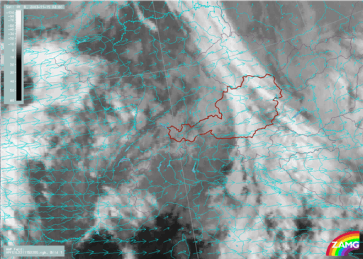
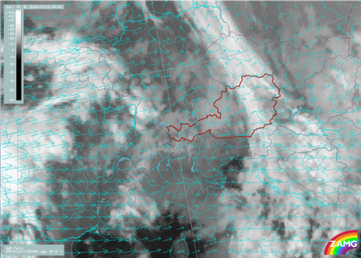
The frontal cloud bands approach the mountain chain with the orientation of the cloud band quasi-perpendicular to the mountain chain. The slower the movement, the more difficult it is for a front to pass over the obstacle. This is expressed quantitatively by the Froud number which relates stability with velocity. Fronts which have both stable stratification and slow displacement suffer decoupling of clouds at different layers. The air does not stream around the mountain chain, but stays behind. Only the higher cloudiness (upper level front) which needs not to be excessively elevated can proceed at the original speed of displacement. The different velocities can also be seen by the help of AMV where the low level cloudiness has vectors which are only half the length of those in the area of high cloudiness. Wind (especially of the LAM) has the direction normal to the mountain chain, whereas in case of Front Delay wind vectors in the vicinity of the mountain are parallel to it.|
15 November 2003/03.00 UTC - Meteosat IR image; cyan: atmospheric motion vectors
|
15 November 2003/04.00 UTC - Meteosat IR image; cyan: atmospheric motion vectors
|
|
|
Problems and open questions
- Both phenomena are quite rarely observed clearly, and are the combination of different effects, the scale (which is much smaller than the whole front), and the short duration (these modifications can develop within a few hours) lead to a lack of precise numerical data.
- A prediction, to show if a front will suffer these modifiactions is not possible. The orientation of the approaching frontal cloud band (at more or less the right angle to mountain chain) as well as key parameters - such as wind speed and stability - give indicators, but these conditions can also occur in cases without front modifications.
- Cloud patterns similar to those of decoupling of frontal clouds at different heights are sometimes observed without the existence of a mountain chain.
- Scandinavian mountains do not show these effects. This can be due to the lower altitude or the different orientation in relation to the prevailing wind direction.
- Cantabrics and Pyrenees do influence frontal clouds as well, but the effect is usually much weaker since the environment is quite different. Namely, on their way to Cantabrics and Pyrenees most fronts move over the ocean from west to east parallel to the mountain chains.


