Front Decay - Meteorological Physical Background
by ZAMG
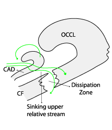
- The involvement of air rotating around the centre of a depression associated with the frontal system.
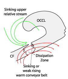
A sinking upper relative stream (or a dry intrusion) can be detected which flows at nearly right angles to the frontal cloud band at low to middle levels, leading to the characteristic decay of cloudiness. At upper levels, a sinking or only a very weakly rising warm conveyor belt can be observed.
|
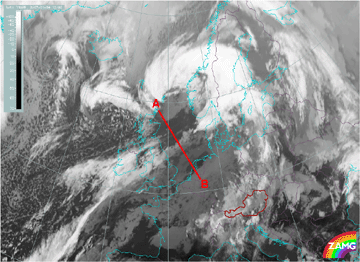
09 October 1999/01.00 UTC - Meteosat IR image; position of vertical cross section indicated
|
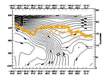
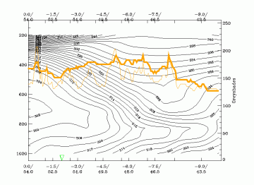
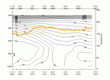
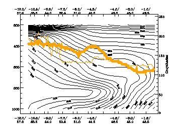
09 October 1999/00.00 UTC - Vertical cross section; black: isentropes (THETAE), orange thin: IR pixel values,
orange thick: WV pixel values
|
|
|
|
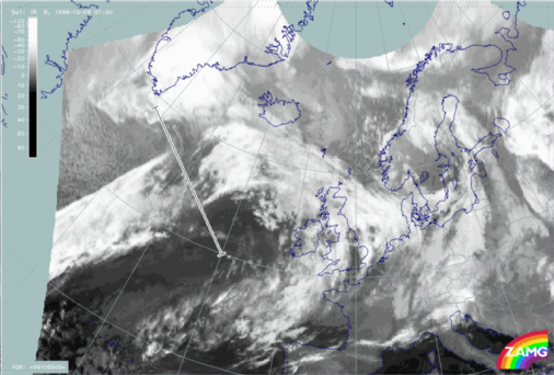
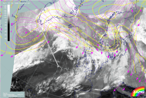
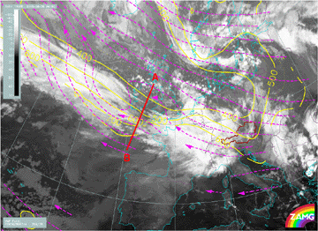
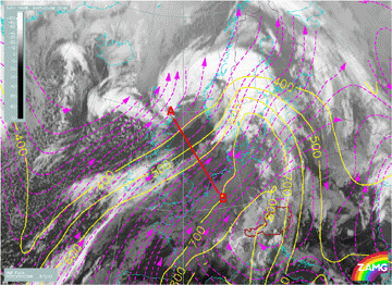
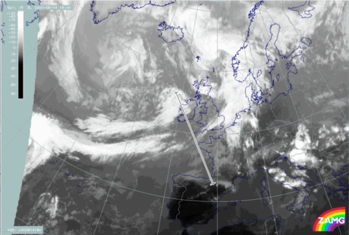
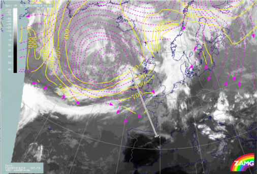
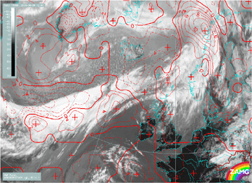
09 October 1999/00.00 UTC - Meteosat IR image; magenta: relative streams 300K - system velocity: 245° 17m/s, yellow:
isobars 300K, position of vertical cross section indicated
|
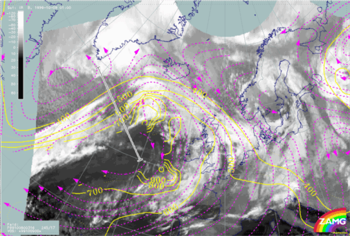
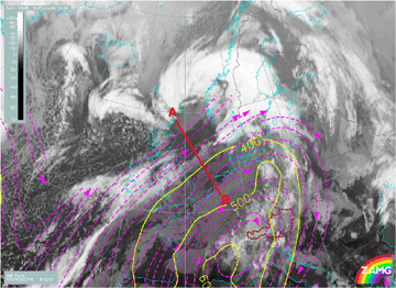
09 October 1999/00.00 UTC - Meteosat IR image; magenta: relative streams 316K - system velocity: 245° 17m/s, yellow:
isobars 316K, position of vertical cross section indicated
|
|
|
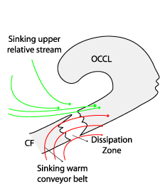
A distinction can be made between cases with rising and sinking warm conveyor belts. In the case of a rising warm conveyor belt any gap within the frontal cloud band will probably close again, while in case of a sinking warm conveyor belt a complete dissipation of cloud in the IR imagery is probable:
Rising warm conveyor belt:
|
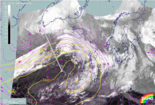
09 October 1999/01.00 UTC - Meteosat IR image; magenta: relative streams 322K - system velocity: 245° 17m/s, yellow:
isobars 322K, position of vertical cross section indicated
|
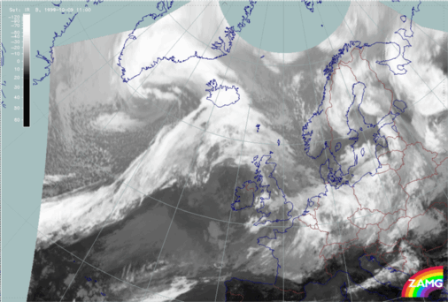
09 October 1999/11.00 UTC - Meteosat IR image
|
|
|
Sinking warm conveyor belt
|
28 August 2006/06.00 UTC - Vertical cross section; black: isentropes (ThetaE), orange thin: IR pixel values, orange thick: WV pixel
|
28 August 2006/06.00 UTC - Meteosat 8 IR10.8 image; magenta: relative streams 318K - system velocity: 289° 36m/s, yellow: isobars 318K;
position of vertical cross section indicated
|
|
|
- The involvement of air masses originating from an area far behind the frontal system (e.g. because of a large low pressure system).
At low and middle levels there is an upper relative stream (dry intrusion) forming an acute angle with the frontal cloud band, together with a sinking or only very gently rising warm conveyor belt at higher levels above the zone of decay.
|
09 January 2007/12.00 UTC - Meteosat 8 IR10.8 image; position of vertical cross section indicated
|
09 January 2007/12.00 UTC - Vertical cross section; black: isentropes (ThetaE), orange thin: IR pixel values, orange thick: WV pixel values
|
|
|
|
09 January 2007/12.00 UTC - Meteosat 8 IR10.8 image; magenta: relative streams 308K - system velocity: 313° 12m/s, yellow: isobars 308K;
position of vertical cross section indicated
|
09 January 2007/12.00 UTC - Meteosat 8 IR10.8 image; magenta: relative streams 316K - system velocity: 313° 12m/s, yellow: isobars 316K;
position of vertical cross section indicated
|
|
|
The majority (60%) of all investigated cases with inflow of air from behind the system fit the model of a sinking upper relative stream at middle levels and a sinking or weakly rising warm conveyor belt very well. The remaining cases again show deviations from this conceptual sub model (e.g. a sinking warm conveyor belt at all levels and no upper relative stream).
- An inflow of air masses influenced by a second system immediately behind the front (e.g. Comma cloud or a cold air development).
Only a few cases (5%) of this type are available. There seems to be a particular characteristic behaviour in the relative stream. A thick sinking upper relative stream can be observed, crossing the frontal cloud band at an acute angle at all levels. There is no warm conveyor belt configuration associated with this type of Front Decay.
|
14 August 2000/18.00 UTC - Meteosat IR image; position of vertical cross section indicated
|
14 August 2000/18.00 UTC - Vertical cross section; black: isentropes (ThetaE), orange thin: IR pixel values, orange thick: WV
pixel
|
|
|
The sinking relative streams are well reflected in the temperature advection fields as distinct CA, which appears within as well as in front of the frontal cloud band.
A sharp transition between WA and CA, crossing the frontal band perpendicularly, almost corresponds to the boundaries of the cloud gap.
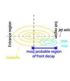
On this basis a Front Decay would be expected in the right exit region, of a jet in an area of distinct downward motion, especially if there is an acute angle between the jet and the frontal cloud band. In reality, this was only found in 30% of all investigated cases. In the diagrams below the most probable area of Front Decay lies along the anticyclonic side of the jet, between the exit region and the jet core. If the process of downward motion over the cloud gap is fully mature, there should also be a distinct maximum of negative vorticity advection.