Front Decay - Cloud Structure In Satellite Images
by ZAMG
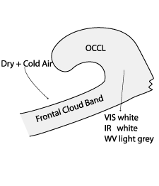
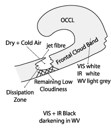
Appearance in Meteosat Second Generation imagery:
- IR imagery:
- The cloud decay generally starts from the colder and dryer rear side of the frontal band, showing an increasing dark or even black area in the IR image
- At an early stage dissipation takes place within high and middle-level clouds, leaving a remaining dark grey stripe associated with lower cloudiness;
- Sometimes a clear bright jet cloud fibre forms at the edge of the cloud gap;
- physical processes, indicated by relative streams, leading either to dissipation of low clouds during the mature stage of the process, or the cloud gap will fill again.
- WV imagery:
- The light grey WV band is darkening from the rear edge;
- The grey shade of the dissolution zone in WV differ depending on the characteristics of individual cases, but a weak WV band structure remains at least in all investigated cases.
- VIS imagery:
- The VIS image shows in most cases low cloudiness remaining even in an advanced state of FD.
- Complete dissolution in a later stage of the life cycle takes place only in 14% of the cases. Rest of the cases shows presence of patches of thin clouds.
|
|
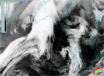
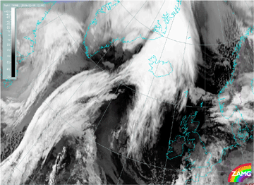
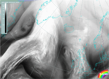
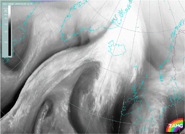
The loop of the IR10.8 images shows that the dissolution of high and middle cloudiness starts at the rear side of the frontal cloud band, and the gap increases with every time step. Only a low narrow cloud band (grey) remains. In this case the development of a bright jet cloud fibre at the rear edge over the dissolution zone can be observed. After 02.00 UTC in the IR10.8 image loop of 18 December 2006 the cloud gap is closing again. This mechanism can often be observed and will be explained in the chapter of meteorological physical background.
|
17 December 2006/18.00 UTC - Meteosat 8 IR10.8 image
|
18 December 2006/12.00 UTC - Meteosat 8 IR10.8 image
|
|
|
|
17 December 2006/18.00 UTC - Meteosat 8 WV6.2 image
|
18 December 2006/12.00 UTC - Meteosat 8 WV6.2 image
|
|
|


