Convergence Lines Over Seas And Lakes - Typical Appearance In Vertical Cross Sections
by KNMI
A Convergence Line over sea, a lake or through a narrow strait is like a small - or mesoscale CM.In this chapter, a few examples of vertical cross sections are presented.
In the Meteosat 8 HRVIS image below a convergence line or cloud street is recognized over the Kattegat, through the Sont, the narrow strait between Denmark and Sweden towards the north west coast of Poland.
10 November 2007/06.00 UTC - Meteosat 8 IR 10.8 image; position of vertical cross section indicated
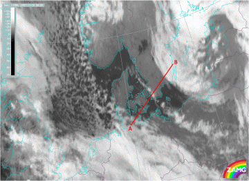
The first cross section is taken along the line of showers, and not across, as is indicated in the above image with the line AB.
For reference see the red arrow in the second Meteosat 8 image of 10 November 2007 / 1200 UTC.
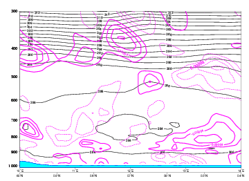
10 November 2007/06.00 UTC - Vertical Cross section; magenta: divergence
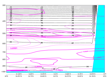
The divergence pattern at 06.00 UTC is depicting little low level convergence (drawn lines, negative value) at the entrance of the Sont (around 56N/12E) with little divergence above (dotted lines, positive value), at about 900 hPa. This is rapidly changing into low level divergence over the Sont with little convergence (at 850 hPa) above and probably along the Swedish southwest coast again minor convergence, coastal convergence with probably explains the line of showers is more over land.
The second cross section is taken from 54N 10E to 57N 16E, across the line of showers over the Sont, along the drawn red line AB in the Meteosat 8 IR 10.8 image of 0600 UTC above.
10 November 2007/06.00 UTC - Vertical cross section; blue: RH
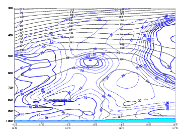
This is a cross section on Relative Humidity. The moisture, at the start (over northern Germany, near Kiel) rather high at low levels up to 850 hPa, is diminishing soon when reaching and passing the east side of the Sont ( 55.5N/13E). Near the west coast of Sweden, which is at the right side of the image, the low level and high level moisture starts to increase on the approach of another weather system. The drier airmass in between the two weather systems is evident and well in accordance with the satellite image.
Cross section along a line through the Sont
In the Meteosat 8 HRVIS image below, 10 November 2007 12.00 UTC, a cross section is taken along the line of showers, parallel to the red arrow.
10 November 2007/12.00 UTC - Meteosat 8 HRVIS image; position of vertical cross section indicated
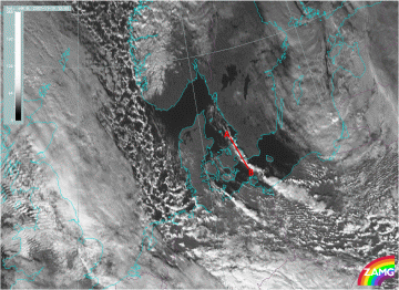
The cross section is a depiction of the divergence pattern at 12.00 UTC from Oslo (60N/10E) through the Sont to Szczecin in the northwest part of Poland.
The most interesting part is at the entrance of the Sont, located around 56N/12.5E.
10 November 2007/12.00 UTC - Vertical Cross section; magenta: divergence
Over the Sont little divergence (dotted lines in purple, positive values) is forecast with low level convergence above, near 800 hPa, not favourable for convection to intensify. In fact the successive satellite images, presented in the chapter on the cloud structure, do indicate the weakening of the line of showers over the Sont. Down south to the coastline, over the west part of the Baltic sea, increasing number of showers illustrate the intensification as a result of coastal convergence (increasing). Part of this evolution may be induced as well by the increasing divergence at higher levels (500 hPa), above the low level convergence at 850 hPa, depicted well in the cross section.


