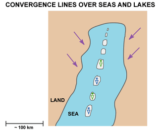
Convergence Lines Over Seas And Lakes - Weather Events
by KNMI
| Parameter
|
Description
|
| Precipitation
|
- Considerable amounts of precipitation within the narrow swaths of cloud lines
- Especially snowfall accumulations can become anomalously high.
- Soft hail is often reported.
|
| Temperature
|
- Falling sometimes rapidly in snow or hail showers
|
| Wind (incl. gusts)
|
- Gusty and fresh, even stormy wind typically on wintertime conditions
|
| Other relevant information
|
Thundery winter storms are not very common, the probability is increasing when upper air features and cold pools are strengthening the effect.
|
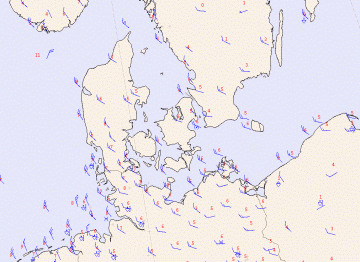
In the synoptic weather chart of 14.00 UTC below some weather observations have an indication of the presence of the convergence line. Notice the distant showers, reported by a weather station in the exit of the Sont. The reported hailshower over the island of R³gen and the reports of hail and snowshowers over the north east part of Poland are second indications Satellite images (see
Meteorological Physical Background) and radar images are of great help for the determination of the extent and the intensity of the convergence line.
10 November 2007/14.00 UTC - Synoptic weather chart with surface wind, temperature and present weather only
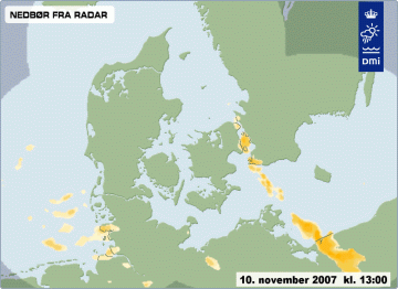
In addition to the synoptic weather chart, with the help of the Danish Meteorological Institute (DMI), an image of the Danish weather radar was received and is presented below. Darker colours indicate the more active parts and cells of the convergence line.
It is clear a single weather report on this weather map, like the isolated hailshower over the north west part of Poland, is part of an extensive line of showers, stretching from the Sont down to the southeast. Satellite and radar images do add value to actual weather and weather forecast.
10 November 2007/12.00 UTC - Image of weather radar supplied by DMI