Orographically Induced Convergence Lines - Key Parameters
by ZAMG and DHMZ
Typical synoptic environment
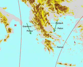
1. Greek convective Convergence Lines
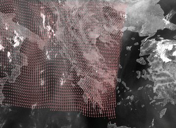
These lines seem to occur in certain synoptic situations:- There is a low or, at least, an upper level low over Turkey and a High over the central Mediterranean.
- An upper level ridge (sometimes also a surface ridge) is situated over Greece.
- As there is no frontal situation over Greece, the equivalent thickness shows only a small gradient; The TFP sometimes shows a positive value originating from a frontal system passing by to the north.
- The isobars at low levels show a weak gradient but with winds from a northerly direction.
|
|
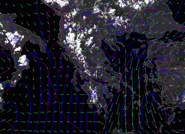
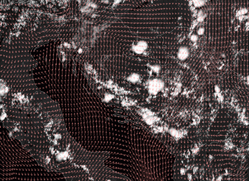
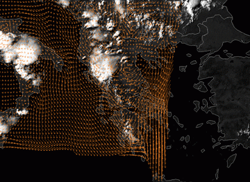
24 July 2007/12.00 UTC Meteosat 8 HRVIS image; magenta: height contours 1000 hPa, blue: height contours 700 hPa, green: wind vectors 1000 hPa
(ECMWF analysis)
|
|
|
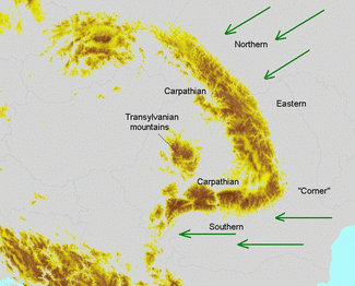
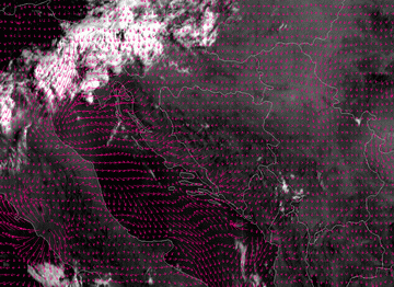
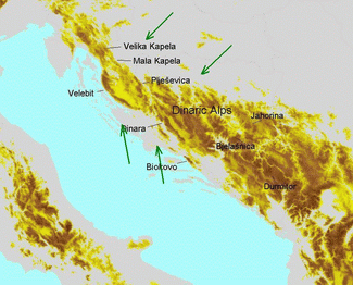
2. The Carpathian Convergence Lines
In case of the Carpathian Convergence Lines, there is no distinct synoptic pattern such as ridge or trough features or even a frontal system.- Large scale winds show quite a homogeneous flow with mainly northerly and easterly components.
|
|
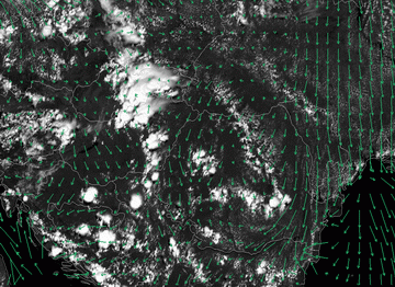
24 July 2007/12.00 UTC Meteosat 8 HRVIS image; green: wind vectors 1000 hPa (ECMWF analysis)
|
|
|
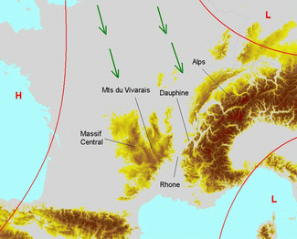
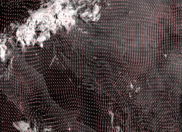
3. Convergence Lines over the French Mountains
- The typical synoptic situation is characterised by a north-westerly upper level flow, a surface low in the Mediterranean near the Gulf of Genoa and high pressure west of the Massif Central (France).
- Situations with a strong north-westerly flow creating a Mistral situation. However, in the case presented here the wind speed is rather low, since the pressure gradients are relatively weak.
|
|
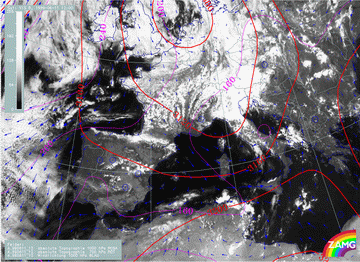
11 June 1999/12.00 UTC - Meteosat 7 VIS image; mangenta: height contours 1000 hPa, red: height contours 700 hPa, blue: wind vectors 1000 hPa
|
|
|
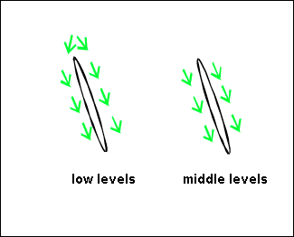
Typical small scale parameters
Wind, convergence and vertical motion data detected in small scale model output show remarkable changes during day. The Greek and the Dinaric Convergence Lines are chosen to show common features. Some additional features are noted for the other Convergence Lines.
Typical distribution of the wind fields in the morning
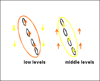
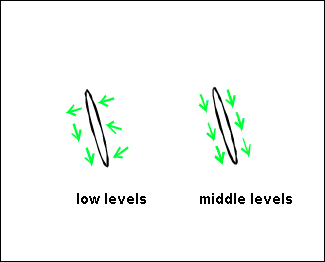
In the morning (06 UTC) divergence (fields not shown here) prevails over the mountain chains whereas convergence occurs at higher levels. The wind fields show a flow around the mountains rather than over them. Orographic effects vanish at 800 hPa where a more or less uniform flow pattern (north-west wind) can be observed.|
24 July 2006/06.00 UTC - Meteosat 8 HRVIS image; wind vectors 925 hPa
|
|
|
|
|
|
|
24 July 2006/06.00 UTC - Meteosat 8 HRVIS image; wind vectors 700 hPa
|
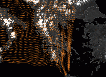
In the example case of the Dinarides the wind in the lower levels is presented by the 10m wind field:
|
24 July 2006/06.00 UTC - Meteosat 8 HRVIS image; 10m wind vectors
|
24 July 2006/06.00 UTC - Meteosat 8 HRVIS image; wind vectors 700 hPa
|
|
|
Typical distribution of the wind fields, convergence and vertical motion at noon
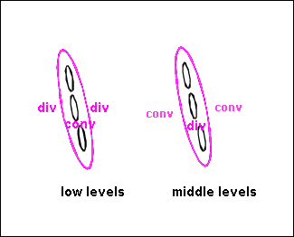
- Wind fields are influenced by orography up to about 700 hPa: There is a confluence at lower levels.
- As a consequence of this wind field, small scale convergence can be observed up to 800 hPa. At the 925 hPa level, the maximum of convergence is shifted to the west (the windward side of the mountain ridge).
- Therefore, the maximum of upward motion can also often be found west of the mountain chain (around 1 degree), in a layer which is somewhat thicker than can be observed for the convergence. Above 700 hPa, there appears to be no upward motion which can be related to convergence cloudiness.
Typical distribution of wind-fields at noon
|
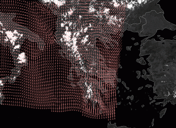
24 July 2006/12.00 UTC - Meteosat 8 HRVIS image; wind vectors 925 hPa
|
24 July 2006/12.00 UTC - Meteosat 8 HRVIS image; wind vectors 700 hPa
|
|
|
|
24 July 2006/12.00 UTC - Meteosat 8 HRVIS image; 10m wind vectors
|
|
|
|
|
|
|
24 July 2006/12.00 UTC - Meteosat 8 HRVIS image; wind vectors 700 hPa
|
Typical distribution of divergence
|
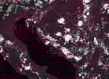
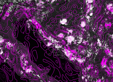
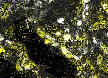
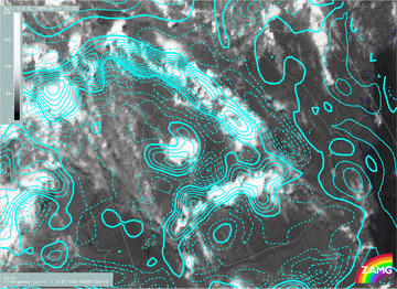
24 July 2006/12.00 UTC - Meteosat 8 HRVIS image; magenta solid: convergence 850 hPa, magenta dashed: divergence 850 hPa
|
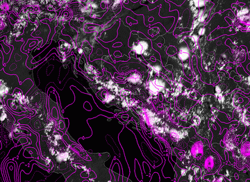
24 July 2006/12.00 UTC - Meteosat 8 HRVIS image; magenta solid: convergence 700 hPa, magenta dashed: divergence 700 hPa
|
|
|
At 700 hPa the flow is more divergent over the mountains, specially in the south-eastern part, suggesting that the phenomenon is rather shallow.
Typical distribution of vertical motion at noon
|
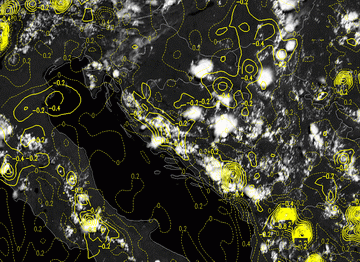
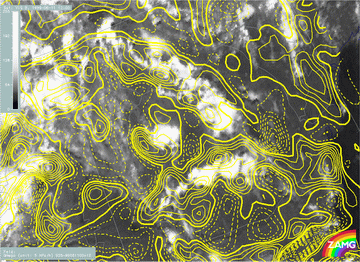
24 July 2006/12.00 UTC - Meteosat 8 HRVIS image; yellow solid: vertical motion - upward motion 850 hPa, yellow dashed: vertical motion -
downward motion 850 hPa
|
24 July 2006/12.00 UTC - Meteosat 8 HRVIS image; yellow solid: vertical motion - upward motion 700 hPa, yellow dashed: vertical motion -
downward motion 700 hPa
|
|
|
Typical distribution of wind-fields in the afternoon
In the afternoon (15.00 UTC) the model parameter are getting similar to those at 06.00 UTC, but they still show some remnants of "daytime features". The convergence zone that developed at noon is starting to decay at this point in time and, consequently, shows a less distinct pattern.Wind fields are reverting to a typical night-time non-convergent flow. However, at that point there are still convective cells along the Line, sometimes even well developed.
|
24 July 2006/15.00 UTC - Meteosat 8 HRVIS image; wind vectors 925 hPa
|
|
|
|
|
|
|
24 July 2006/15.00 UTC - Meteosat 8 HRVIS image; 10m wind vectors
|
Additional features apparent in the Carpathian Convergence Lines
- In general, the wind field can be characterised by north-easterly winds east of the Eastern Carpathians which become south-easterly winds at the Southern Carpathians. Therefore, there are components directed towards the mountain ranges. In Transylvania southerly and easterly winds prevail. In addition, the wind field shows a lot of small vortices within this orographic region.
- As a consequence of the wind field, areas of convergence can be found at lower levels. At 925 hPa it is more or less associated with the lines of cloudiness. The Southern Carpathians and the Eastern Carpathians show two separate areas of convergence with a small area of divergence at the "corner".
- In the afternoon and evening, some small areas of convergence still exist, although they are more likely connected with huge convective cells (MCS) which can survive for longer points of time.
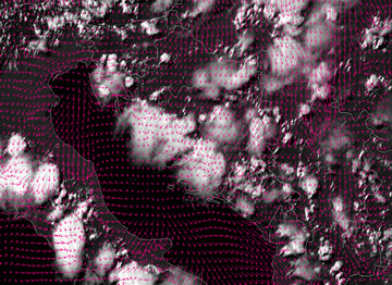
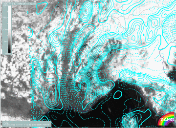
11 June 1999/12.00 UTC - Meteosat 7 VIS image; cyan solid: convergence 925 hPa, cyan dashed: divergence 925 hPa
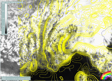
11 June 1999/12.00 UTC - Meteosat 7 VIS image; yellow solid: vertical motion - upward motion 925 hPa, yellow dashed: vertical
motion - downward motion 925 hPa
Additional features for the Convergence Lines in the French mountains
- The wind fields show northerly directions becoming northwest and west with height but show distinct confluence at several mountain ridges (Massif Central, Jura mountains, West Alps) leading to upward motion from the surface up to levels of 850/800 hPa.
|
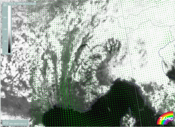
11 June 1999/12.00 UTC - Meteosat 7 VIS image; green: wind vectors 925 hPa
|
11 June 1999/12.00 UTC - Meteosat 7 VIS image; cyan solid: convergence 925 hPa, cyan dashed: divergence 925 hPa
|
|
|
|
|
|
11 June 1999/12.00 UTC - Meteosat 7 VIS image; yellow solid: vertical motion - upward motion 925 hPa, yellow dashed:
vertical motion - downward motion 925 hPa
|


