Orographically Induced Convergence Lines - Meteorological Physical Background
by ZAMG and DHMZ
The convergence in these areas can be explained by two different effects:
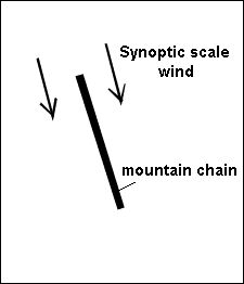
- A typical synoptic situation showing a large scale wind field in low and middle levels with wind directions more or less
parallel to the mountain chain. For the most of the mountain chains studied this means a northerly synoptic-scale flow, whereas in some cases
Convergence Lines develop in westerly or north-westerly flow.
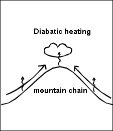
- The orography changes the wind field in direction as well as in speed. During the morning, in mountainous areas, there is a
flow around an obstacle, and during the day the wind develops a component towards the mountains. The speed is quite low and there is a
flow up the slopes. This can be explained by diabatic heating by the mountainous surface during daytime. (In the study made by ZAMG and DHMZ,
cases from June to September were chosen since the Convergence Lines are better developed during the summer due to higher levels
of solar radiation). During morning hours sensible heat is transferred from the ground to the air because of the incoming solar radiation. The
air over the slopes, which is warmer than the one in the valley, rises up the mountain slopes creating upslope flows. During that time
convective boundary layer (CBL) height grows above the heated surfaces. Wind speeds increase as the CBL height grows to higher altitudes. They
usually peak in the late afternoon when the CBL reaches its maximum depth. The wind up the slopes is determined by the topographic features like
slope angle and friction. The curvature of a slope also induces some vertical motion. This wind field results in convergence directly over the
mountain chains or sometimes slightly shifted to the leeward side. Upward motions can be found in the regions of convergence.
The strength of the upslope wind also depends on the climate of the area being observed. Mountains in moister climates, for example, have weaker diurnal mountain wind systems, because of the weaker sensible heat fluxes. For mid-latitudes these winds are the strongest during the warmer part of the year (mostly during summer months), and convective Convergence Lines can be observed mostly during this period. The strength of the upslope winds can get modified by the cloud cover, and is also sensitive to microclimatic variations.
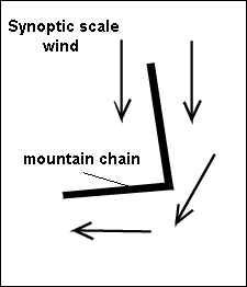
The Convergence Lines forming over the Carpathian mountains indicate a more complicated physical background: There are two "branches" of mountain chains. In case of northerly synoptic scale wind flow, the Eastern Carpathians are orientated in the same direction as the wind whereas the Southern Carpathians are more or less perpendicular to it. Therefore the convective cloudiness along the southern Carpathians cannot be explained by the same theory. As described in more detail in the chapter "key parameters" (see Key parameters ), a flow around the two mountain ranges as well as a small scale cyclonic rotation only at low levels can be observed in the majority of cases; this might be an explanation for a component towards the Southern Carpathians. At the transition between the Eastern and the Southern Carpathians (the "corner"), cloudiness is weakest. This is in accordance with an area where convergence is low or even divergence may be occuring.
The Transylvanian mountains also influence the wind field. There is a flow around them in the morning and a flow over them at noon.