Coastal Convergence - Meteorological Physical Background
by FMI
This chapter describes a flow in which friction is the main driving force for cloud development. Stau Cloudiness and Lee Cloudiness conceptual models describe circulations primarily caused by more distinct orography (mountains and hills). It has to be kept in mind, however, that other factors besides friction, such as the differential heating between land and sea or the topography and shape of the coast have a marked influence on the dynamics of Coastal Convergence. Purely thermally driven circulation on the coast is called the Sea-Breeze.
Physical background
Modification of the wind due to friction near the surface produces an ageostrophic component of the wind towards lower pressure. This is a direct result of the three-way balance between the pressure gradient force, the Coriolis force and the viscous force. Generally this can be seen as backing of the wind in boundary layer.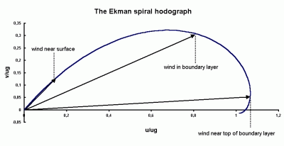
Friction not only causes the wind to back but also slows down the air flow in the boundary layer. Wind blowing from sea to land is decelerated, while the opposite is true for wind blowing offshore. The adjustment of wind speed to changes in surface roughness is a much faster process than the adjustment of wind direction. Typically, a geostrophic wind having a speed of 10 m/s is adjusts itself at 20 km distance from coast. By contrast, wind direction is adjusted much slower, length scale typically being on the order of 500 km.
The differences in both the speed and direction of wind across the coast lead to small-scale convergent and divergent areas and associated vertical motions. The locations of convergence-divergence driven vertical motions naturally depend on the orientation of the coastline with respect to the flow. The basic types of frictional convergence can be described schematically as follows:
|
Direct onshore flow deceleration at coast
|
Direct offshore flow acceleration at coast
|
|
|
|
Onshore deceleration and increased backing of the wind over land
|
Offshore acceleration and decreased backing of the wind over sea
|
|
|
|
Offshore acceleration and decreased backing of the wind over sea
|
Onshore flow and increased backing of the wind over land
|
|
|
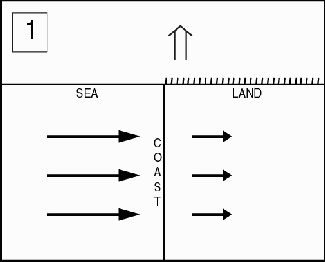
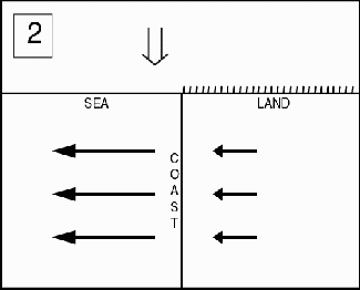
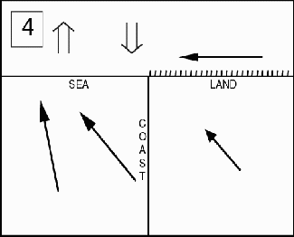
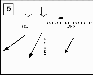
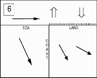
The diagrams 1 and 2 shown in the upper row represent a flow blowing over coast at an acute angle. This will result in convergence for onshore wind and divergence for offshore wind. The convergence or divergence patterns induce ascending or descending motions, respectively.

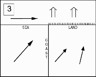
The flow configurations already described in diagrams 3-6 show the convergence-divergence patterns and the vertical motions when the airflow has a small angle with respect to the coastline. The most interesting type is case number 3, where onshore wind blowing from southwest has a major influence on ascending motion over land. This applies to a north-south -oriented coastline; more generally the type could be described as follows:
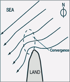
The most intensive Coastal Convergence by friction is induced when the wind blows parallel or in small angle onshore, the lower pressure being to the left of the wind component parallel to the coast.
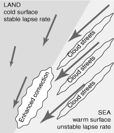
Recent studies have shown that low-level stability conditions modify the general pattern described above. A warm surface generally enhances momentum transfer and wind speed, and reduces the cross-isobar angle. This transforms to rapid acceleration and downstream veering of offshore winds as they enter a warm, smooth sea. Cold sea, on the other hand, strongly inhibits vertical momentum transfer. This leads to offshore winds, and even decreasing in speed in some cases. In these cold sea cases, the induced coastal convergence and rising motion typically are inhibited near surface and only become distinguishable approximately 100 m above the surface.
Respectively, an onshore flow on to cold land may bring along rapid deceleration and strong inland backing of winds. The deceleration is weaker and more gradual over warm land.
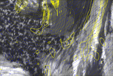
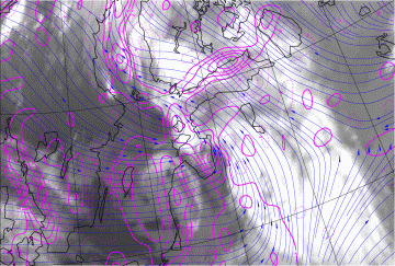
Alternating land contours, such as narrow peninsulas, islands, bays, etc. have an influence on the low-level air flow and can cause complex patterns of divergence and convergence, resulting in complex patterns of enhanced convective lines adjacent to the coast. The following diagram illustrates the effect of north-pointing narrow peninsula for a northeasterly flow. In the example shown above the local maxima of convergence over and northeast of Brittany may partially be explained with peninsula effect.
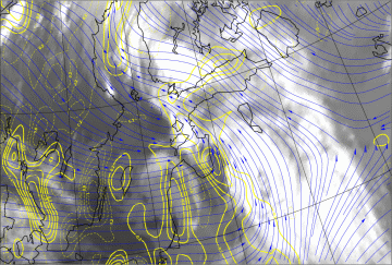
The example shows that even when the frontal cloudiness hides the Coastal Convergence, it still indirectly can give valuable information for diagnosis: the orientation of the frontal cloud in respect to the coastline may assist in evaluating the likelihood of Coastal Convergence - even without the numerical wind fields. If the frontal cloudiness remains stationary for a period of time, the probability of appreciable enhancement of coastal precipitation increases.
|
13 January 2007/12.00 UTC - Meteosat 9 IR10.8 image; magenta: divergence 1000 hPa, blue arrows: 10-metre-wind streamlines
|
13 January 2007/12.00 UTC - Meteosat 9 IR10.8 image; yellow: omega 925 hPa, blue arrows: 10-metre-wind streamlines
|
|
|
|
|
|
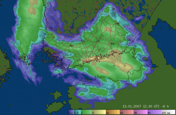
13 January 2007/12.00 UT
|


