CAPE
by FMI and ZAMG
Hence, a key to the possibility for the growing of convective storms is the presence of CAPE, not the environmental lapse rates alone. Not all situations with conditional instability are characterised by air parcels with CAPE. Thus, the moisture content of the air is important for knowing whether conditional instability actually contains the potential for parcels to become buoyant. In that case, an external source of energy must be supplied to the air mass to convert its potential instability into actual instability and lift the parcel through its condensation level to its Level of Free Convection (LFC) - that means, for instance, the change from potential instability to conditional instability. The amount of this supplied energy is known as the Convective Inhibition (CIN).
From the LFC to the Equilibrium Level (EL), the parcel accelerates vertically, drawing the energy for this acceleration from the CAPE.
Convective Available Potential Energy
All levels of sounding or pseudotemp are used for the calculation of CAPE. The unit of CAPE is J/kg and it describes the maximum amount of potential energy which the air parcel has available for convection. CAPE is calculated by integrating over height the (virtual) temperature difference of lifted air parcel and the environment. In a thermodynamic diagram this represents the area that is between the curve of lifted air parcel and that of the environment. The integration normally is started from level of free convection (LFC) which is the level above which the lifted parcel is warmer than environment. The upper limit for the integration is the level of neutral buoyancy (LNB) in which the parcel and environment curves meet again.
The formula for CAPE is as follows:
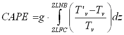
where g= acceleration by gravity, z = height (m), T´v = virtual temperature of the air parcel and Tv = virtual temperature of the environment. CAPE can also be calculated using temperatures instead of virtual temperature. Also pressure coordinates can be used instead of height coordinates.
CAPE values in pre-thunder conditions range from a few hundreds of J/kg up to thousands of J/kg. The greatest observed values are of the order of 5000-7000 J/kg.
The definition of CAPE doesn't take into account the existence of entrainment, liquid water loading, aerodynamical effects or the vertical motions in the environment, which have a decreasing effect on the value of CAPE.
CAPE can also be calculated with starting integration level not being the LFC, but instead, either a fixed level (e.g. 850 hPa), a lifted condensation level (LCL) or a convective condensation level (CCL).
|
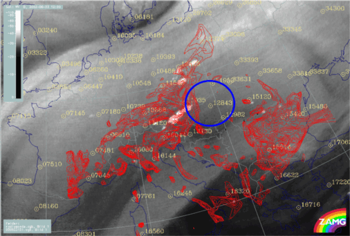
23 June 2002/12.00 UTC - Meteosat WV image; red: Isolines of CAPE >= 600 units/40 units; position of sounding from Budapest
(12843) indicated
|
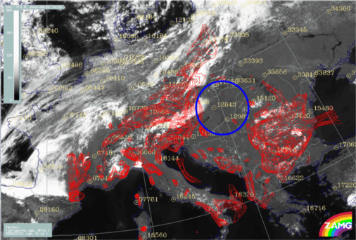
23 June 2002/12.00 UTC - Meteosat VIS image; red: Isolines of CAPE >= 600 units/40 units; position of sounding from Budapest
(12843) indicated
|
|
|
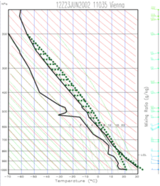
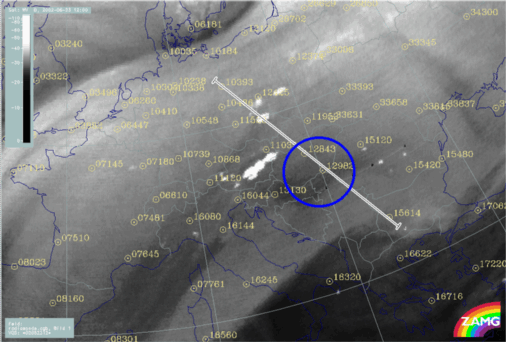
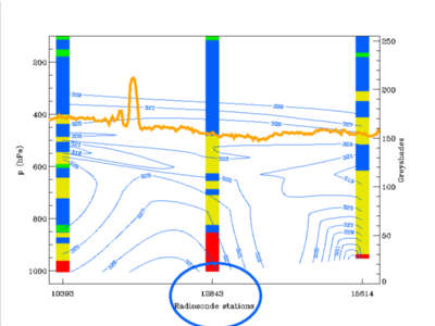
The red isolines represent CAPE for 12.00 UTC derived from the ALADIN model >= 600 units. Intense DMC is associated with higher values of CAPE. In the images below a vertical cross section is indicated (left) which includes three radio soundings; the vertical distribution of derived equivalent potential temperature, interpolated from the radio soundings is shown on the right). Station 12843 (Budapest) shows a significant amount of conditional instability up to 500 hPa (some flat stable layers included) and a weak decrease of ThetaE around 500 hPa. But there is no convective activity so far (12.00 UTC), despite the amount of conditional instability. It can be clearly seen in the images above that there is not sufficient CAPE in the vicinity of Budapest, therefore there is insufficient energy for lifting the air to condensation level and further to the LCL. The CIN could not be overcome by the CAPE in this area.
|
23 June 2002/12.00 UTC - Meteosat WV image; position of vertical cross section and sounding from Budapest (12843) indicated
|
23 June 2002/12.00 UTC - Vertical cross section; blue: equivalent potential temperature, stability analysis, position of sounding from
Budapest (12843) indicated
|
|
|


