CONVECTION AND INSTABILITY
by ZAMG
Large scale areas often contain synoptic conditions suitable for the development of convection, however, convective features are much smaller scale. The concept of a buoyant air parcel is best understood using hydrostatic information describing the state of the air column above. Information about the quality of an air column can be gained from radio soundings or with model derived soundings (e.g. from a LAM model like ALADIN or HIRLAM). Consequently, for single CB's and MCS's other parameters and their vertical distribution become more important than those commonly associated with larger scale conceptual models.
Atmospheric conditions for convection
- Convection in general is mass motion within a fluid resulting in transport and turbulent mixing of the properties of that fluid by vertical movement, in matters of transport of energy (heat), water vapour and momentum. As such, it is one of the three main processes by which energy (heat) can be transported vertically: radiation, conduction, and convection.
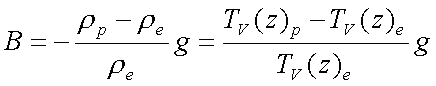
The difference in density (left term) or in virtual temperature (right term) between the rising parcel (p) and the parcel environment (e) causes the updraft. Consequently, a parcel with greater temperature and less density will be controlled by buoyancy and displaced vertically. The virtual temperature is conservative in association with the moisture within the parcel.
Vertically integrated the right term in the buoyancy formula gives the amount of available convective energy (see Numerical Parameters for Small Scale Convective Cloud Systems - Cape). It is clear that the vertical displacement and acceleration of an air parcel is directly associated to buoyancy.
Atmospheric convection is nearly always turbulent and it can take many modifications in the atmosphere:
- Dry thermals, which do not reach their level of saturation. Mostly in the boundary layer convection is dry with relative humidities less than 100%. In this case there is no cloud formation and therefore those turbulent plumes can not be seen in the satellite images.
- Buoyant plumes of moist warm air, reaching the saturation level and forming visible cumuliform clouds. Depending on the conditions of the atmosphere they might grow into severe convective weather events (thunderstorms resulting in large hail, damaging wind gusts, tornadoes, and heavy rainfall) which are generally the result of released energy by phase changes of water.
During the condensation latent heat energy is released and additionally contributes to buoyancy. Most of the energy is expended against gravity, but the remaining portion of available energy is responsible for the severity of the convective weather event.
The vertical transport of moisture through convection above levels of 600 hPa can be seen in the WV image. The term convection, commonly associated with this type, is henceforth referred to as deep moist convection (DMC). Shallow convection with less vertical extent can be observed earlier in the VIS and the IR channel.
2 main types of convection can be distinguished:
- Free convection (also called gravitational or buoyant convection): motions that are
predominantly vertical and driven by buoyancy forces arising from hydrostatic instability,
with locally significant deviations from hydrostatic equilibrium.
Free convection can mostly be related to diabatic heating through insolation (short wave radiation) on surfaces with higher heat capacity than the neighbouring environment or thermal forcing through greater diabatic heating at elevated surfaces. - Forced convection: motion induced by mechanical forces such as deflection by a large scale
surface irregularity, turbulent flow caused by friction at the boundary of a fluid, or
motion caused by any applied pressure gradient.
Furthermore this type of convection is caused by lifting owing to dynamical convergence, lifting through orography, lifting within the lee circulation of a mountain ridge or gravity waves.
The unstable stratification of the atmosphere is the cause of deep moist convection, whatever the reason may be for convective initiation or the type of appearance of convective cells. Therefore the different types of instability are now considered further:
Convection and Instability
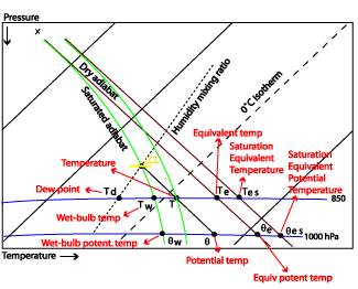
The origin of instability is heat, both latent and sensible, that is produced as a result of solar heating and evapotranspiration of water vapour (also due to solar heating) in the lower troposphere. Convection transports the excess sensible heat and water vapour from low levels into the upper troposphere, and transports cooler, dry air downward, thereby reducing the instability. Thus the instability is initiating DMC, but convection will only continue until the instability is removed.Hydrostatic stability is a state variable for the stratification of the atmosphere or at least of a column of air. It can be indicated by various variables like temperature, humidity or density. The change, usually a decrease of those parameters, is shown in the lapse rate. In the hydrostatic approach the process lapse rate is distinguished from the environmental lapse rate of the lifted air parcel. For parcel theory, the term "environment" means the immediate vicinity to the parcel. This environment is not affected by the processes applied to the parcel.
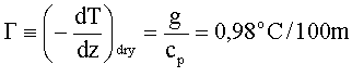
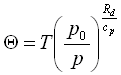
The dry adiabatic lapse rate of an air parcel is the rate of decrease of temperature with height of a parcel of dry air which is lifted through the atmosphere in hydrostatic equilibrium. That means if a parcel of air is vertically displaced without saturation its temperature will change with the amount of Γ
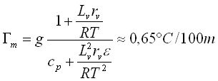
During the process of lifting an air parcel will cool and may reach the point of saturation. If it is still buoyant and continuing its ascent, its temperature will decrease moist adiabatically. The moist adiabatic lapse rate is smaller because of the release of latent heat through condensation:
where
| g | Gravity |
| cp | Specific heat |
| Lv | Latent heat |
| R | Gas constant |
| rv | Mixing ratio of water vapour |
| T | Temperature |
| ε | Rd/Rw |
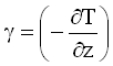 . The relation between γ and Γ/Γm is the degree for stability:
| Unsaturated | Saturated | |
| γ > Γ | unstable | γ > Γm |
| γ = Γ | neutral | γ = Γm |
| γ < Γ | stable | γ < Γm |
| T | Temperature |
| p | Pressure |
| p0 | Pressure at surface level |

| L | Latent Heat |
| q | Moisture |
| cp | Heat capacity at constant pressure |
| Unsaturated | Saturated | |
 ,
,

|
unstable |

|
 ,
,

|
neutral |

|
 ,
,

|
stable |

|
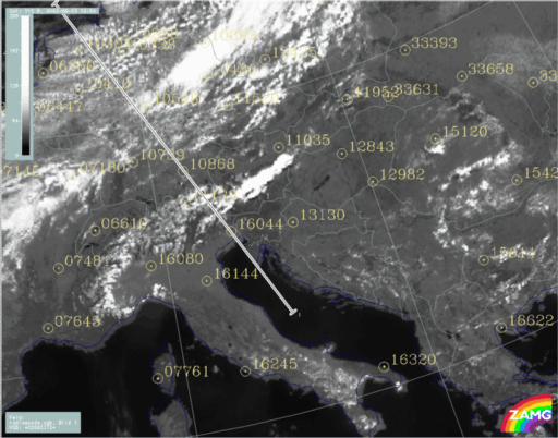
The example of the 23rd June 2002 at 12.00 UTC (VIS image below) shows a situation with an MCS over Austria, a Cold Front over northern Europe and cold air cloud features over Northern Germany. The position of a vertical cross section and the major European radiosonde stations are indicated.
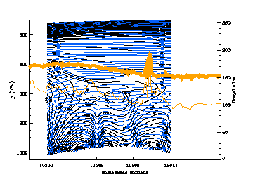
The orange lines indicate IR (thin) and WV (bold) pixel values. The peak between the stations 10868 and 16044 represents the convective cell seen in the VIS image above.
|
23 June 2002/12.00 UTC - Vertical cross section; blue: temperature (derived from radiosoundings), black: isentropes (ThetaE), orange thin:
IR pixel values, orange thick: WV pixel values
|
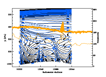
23 June 2002/12.00 UTC - Vertical cross section; blue: potential temperature (derived from radiosoundings), black: isentropes (ThetaE),
orange thin: IR pixel values, orange thick: WV pixel values
|
|
|
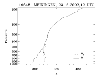
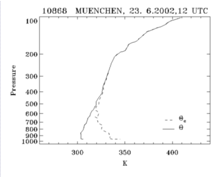
Observing the vertical distribution of Θ and Θe in more detail, the right image above shows a steep decline of Θ (blue) around the station 10548 Meiningen and 10868 Munich but no decrease.
The decrease of the equivalent potential temperature Θe (black) is very weak at Meiningen which is the station more to the north. While Munich clearly shows a decrease of Θe up to 600 hPa, indicating unstable stratification. The difference in the vertical gradient of the equivalent potential temperature between the two stations can also be seen in the two plots below.
|
23 June 2002/12.00 UTC - Radiosounding Meiningen (10548); black: solid: potential temperature lapse rate, dotted: equivalent potential
temperature (ThetaE) lapse rate
|
23 June 2002/12.00 UTC - Radiosounding Munich (10868); black: solid: potential temperature lapse rate, dotted: equivalent potential
temperature (ThetaE) lapse rate
|
|
|
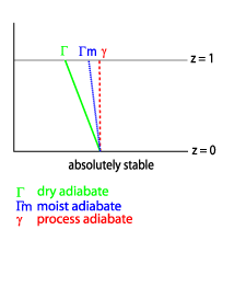
Absolutely stable
| γ < Γm |
,
|
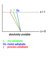
Absolutely unstable
| γ > Γm |
,
|
Potentially (convectively, thermally) unstable
This condition represents the state of a humid but unsaturated parcel of air with an equivalent-potential - temperature that decreases with height. That means that air parcel motion is stable with respect to unsaturated vertical displacements and unstable with respect to saturated vertical displacements. The lapse rate in this layer steepens to a rate greater than the pseudo-moist adiabatic lapse rate (pseudo-moist is moist adiabatic without its liquid water content).
If such a column is lifted until completely saturated, it will become unstable regardless of its initial stratification. Its lapse rate will then exceed the moist adiabatic lapse rate.
The decrease of potential temperature with height as such is a sign for absolute instability. A column of air is potentially unstable when the equivalent potential temperature is decreasing even if there is an increase of potential temperature. But potential instability as such is not necessarily the cause of strong convective development and heavy thunderstorm activity.
The probability for severe weather and storms rises if the air parcel reaches saturation and additional latent heat is released supporting the lift. This situation is then called:
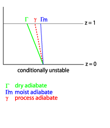
Conditionally unstable
|
Γ > γ > Γm
valid for a saturated state |

|
When the environmental lapse rate is greater than Γ, an air parcel is unstable whether or not it is saturated. If the environmental lapse rate is less than pseudomoist adiabatic, the atmosphere is conditionally stable. If γ = Γm the atmosphere is neutral with respect to saturated vertical displacements.
According to the saturation the equivalent potential temperature Θe has to be replaced by Θes which is the saturation equivalent potential temperature. It is the equivalent potential temperature an air parcel at the same pressure and temperature would have when it is saturated.
Short discussion of the difference between potentially unstable and conditionally unstable
An upward decrease of Θe (potentially unstable) implies conditional instability, too, but if there is no saturation the layer of air might remain potentially unstable. Since Θe is not a state variable for unsaturated air unless completely saturated, the air can be potentially unstable, neutral or quite stable, when Θe decreases upward. When the parcel is lifted until saturation, the decrease of Θe is changed into a decrease of Θes. When the air is not completely saturated, Θes is not conserved. But when the air is saturated and Θes = Θe, both are conserved. At this point during the lifting process the air mass becomes more unstable due to the additional release of latent heat: strong convective developments are highly probable. In other words: only if the vertical displacement is sufficient enough and a potentially unstable layer or parcel is lifted to saturation it will become conditionally unstable.|
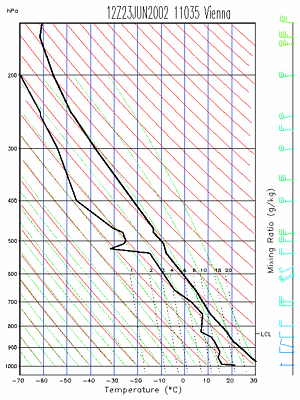
23 June 2002/12.00 UTC - Tephigramm Radiosounding Vienna (11035)
|
|
|
|
|
|
|
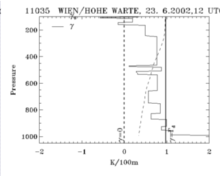
23 June 2002/12.00 UTC - Radiosounding Vienna (11035); black: distribution of lapse rates
|
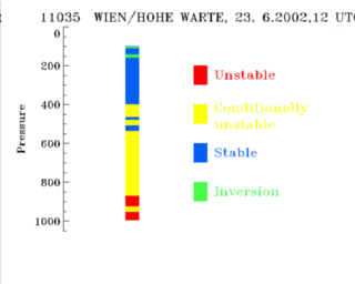
23 June 2002/12.00 UTC - Radiosounding Vienna (11035); stability analysis
|
|
23 June 2002/12.00 UTC - Radiosounding Vienna (11035); black: solid: potential temperature lapse rate, dotted: equivalent potential
temperature (ThetaE) lapse rate
|
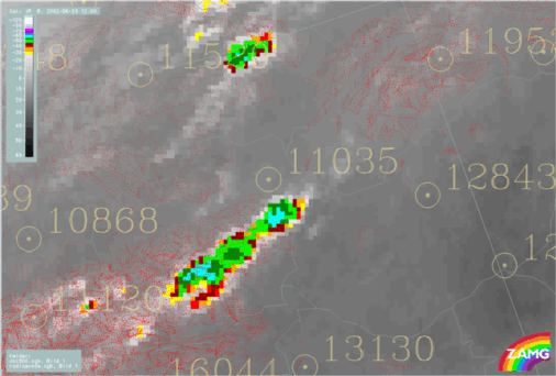
23 June 2002/12.00 UTC - Meteosat IR enhanced image; yellow: radiosonde stations
|

|
|
Other kinds of instability
Buoyantly unstable:This kind of instability is more important when associated with gravity waves and hydrodynamic instability. It is mentioned at this point for the sake of completeness. Here buoyancy is the only restoring force on displacements. When lifting dry-adiabatically the air parcel requires the lapse rate of temperature greater than the adiabatic lapse rate. Also the environmental lapse rate of density is grater than the process density lapse rate. Since the vertical acceleration is zero in a hydrostatic atmosphere, buoyancy is associated with an unbalanced pressure gradient force, mostly caused by density perturbations.
Change in Stability
Horizontal advection of parameters like temperature, density and relative humidity are able to change the state and type of instability. Typical vertical distributions for the tendency of stabilisation or labilisation are well defined and can be observed in radio soundings and model derived soundings. The horizontal advection can be seen in the vertical distribution of the wind field. Also differences in strength and direction are responsible for convective development and type of convection (single cells, super cells, squall lines, organised convection). Curves describing the vertical change of the wind direction are called "Hodographs". The schematic below describes all possible vertical wind distributions associated with the effects of stabilisation or labilisation of a layer of air.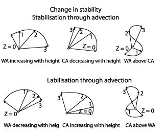
|
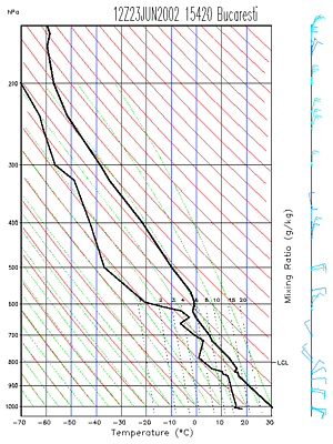
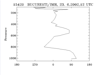
23 June 2002/12.00 UTC - Tephigramm Radiosounding Bucharest (15420)
|
|
|
|
|
|
|
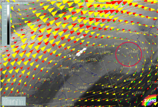
23 June 2002/12.00 UTC - Meteosat IR enhanced image; yellow: wind vectors 300 hPa, red: wind vectors 500 hPa, green: wind vectors 850 hPa,
position of Bucharest radiosonde station (15420) indicated
|
23 June 2002/12.00 UTC - Radiosounding Vienna (11035); black: wind direction
|
Entrainment
Most convective clouds are driven by positive buoyancy, with virtual temperature greater than the environment, but clouds with precipitation, evaporation, and/or melting can produce negatively buoyant convection. If there is not sufficient moisture in lower levels, low moisture content in upper levels will cause too much evaporation and therefore negative buoyancy.Evaporation is also caused through turbulent entrainment of dry air into a Cumulonimbus cloud. That means if there is insufficient moisture in the lower levels to be lifted to saturation a growing CB might "dry out" through entrainment. Here evaporation leads to a cooling of the rising air parcel and thus to negative (downward) buoyancy and consequently stops or hinders DMC.

