STABILITY INDICES
by FMI
All indices, however, eventually give only one numerical value (which may be dimensionless). This value represents the potential for convection at a certain fixed location (either the radio sounding site, if the index calculated from radio sounding data or a numerical model grid point, if numerical data used for calculation). The value of the stability index is compared to some statistical threshold value differentiating e.g. non-thunderstorm and thunder storm cases.
For air mass classification purposes index values are plotted and analysed on a weather map, preferably with a suitable satellite underlay image. This latter method is particularly effective for model derived stability indices, since model derived soundings can be calculated at each model grid point for each model time step.
In meteorologiy, the use of convection indices varies from country to country, reflecting different methods, but also the different climatologies. A full list of indices used would contain tens of different indices and would go beyond the scope of this manual. For this reason only a small selection of stability indices - containing those used in this manual - is presented in this chapter.
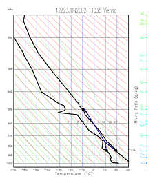
Showalter Index (SI)
Showalter index is calculated using temperature and dew point at 850 hPa and temperature at 500 hPa. The method is as follows: air parcel is lifted dry-adiabatically from 850 hPa level to the lifted condensation level (LCL) and from LCL up to 500 hPa moist-adiabatically. The result T´850->500 is subtracted from the actual 500 hPa temperature T500:|
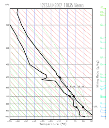
23 June 2002/12.00 UTC - Radiosounding Vienna; The black dots denote the critical levels used for the calculation of Showalter index.
The blue dashed line represents the path of lifted air parcel from 850 hPa to 500 hPa.
|
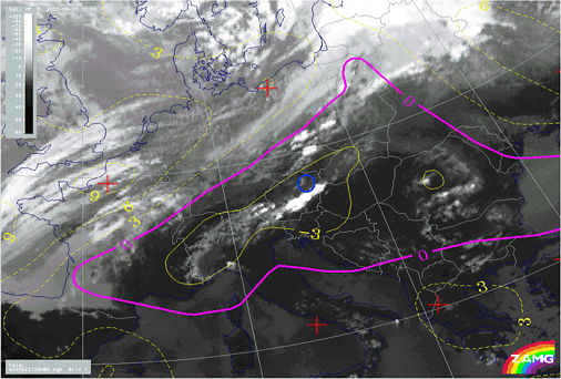
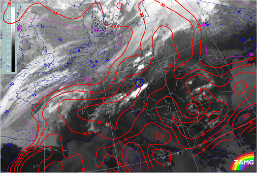
23 June 2002/12.00 UTC - Meteosat IR image; yellow, magenta: Showalter index, position of radiosounding Vienna
indicated
|
|
|
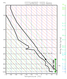
Boyden Index (BI)
The Boyden index has been developed to allow better diagnosis of frontal thunderstorms. No humidity information is included in the calculation. The index is calculated using the following formula:in which Z700-1000 is the thickness of the layer between 700 and 1000 hPa in decametres, T700 the temperature (in degrees Celsius) at 700 hPa. Scaling factor 200 is used to bring the absolute values of the Boyden index close to a range from 90 to 100. Since the index doesn't contain surface temperature information, there is little variation between continental and marine air masses. The diurnal variation is also small.
The higher the value of the Boyden index, the greater the risk of thunderstorm. The threshold value is approximately 95.
|
23 June 2002/12.00 UTC - Radiosounding Vienna; The critical levels for the calculation of Boyden index are shown as black dots
(denoting 700 hPa temperature) and green line (denoting the thickness between 700 and 1000 hPa).
|
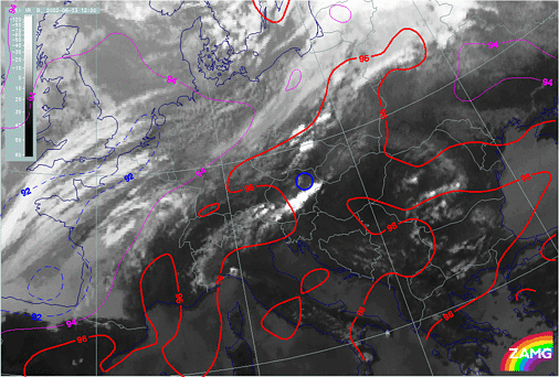
23 June 2002/12.00 UTC - Meteosat IR image; blue: Boyden index < 92, magenta: Boyden index = 94, red: Boyden index > 96,
position of radiosounding Vienna indicated
|
|
|
K-Index (KI)
George's K-Index takes into account three components important for convective instability: temperature lapse rate, lower tropospheric humidity and the vertical extent of the humid layer. The index is calculated as follows:where T850=temperature at 850 hPa, T500 = temperature at 500 hPa, Td850 = dewpoint at 850 hPa, T700 = temperature at 700 hPa and Td700 = dewpoint at 700 hPa. Temperatures are given as degrees Celsius.
A K-Index lower than 20 indicates zero likelihood of thunderstorms, while K-index value higher than 35 indicates likelihood of numerous thunderstorms. As the lapse rate in a cold air mass differs from that in a warm air mass by several degrees, definitive threshold values for K-index are difficult to calculate.
|
23 June 2002/12.00 UTC - Radiosounding Vienna; The critical levels for the calculation of K-index are shown as black dots.
|
23 June 2002/12.00 UTC - Meteosat IR image; blue: K-index < 15, magenta: K-index = 20, red: K-index > 25, position of
radiosounding Vienna indicated
|
|
|

