AVALANCHE CATASTROPHE 05 - 25 FEBRUARY 1999 - COLD FRONT CROSSING
by ZAMG
Cold Front crossing with remarkable "Lee clearing"
The typical synoptic situation can be summarized as:- A Cold Front crosses the Alpine region from north to south accompanied by a distinct thickness gradient
- WA changes to CA during the passage of the front over the Alps
- PVA exists but impact on precipitation not clear
- Main cloud features: Cold Front band, Stau features, "Occlusion - formed Stau", Lee clearing
For the complete sequence of satellite images during this phase see Overview - Phase 4 and Overview - Phase 7 .
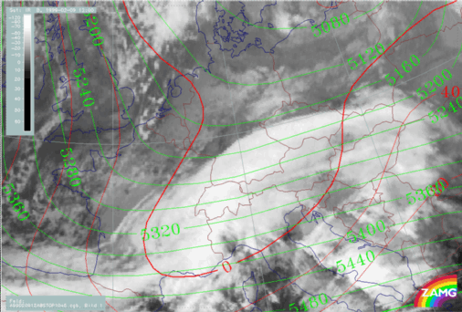
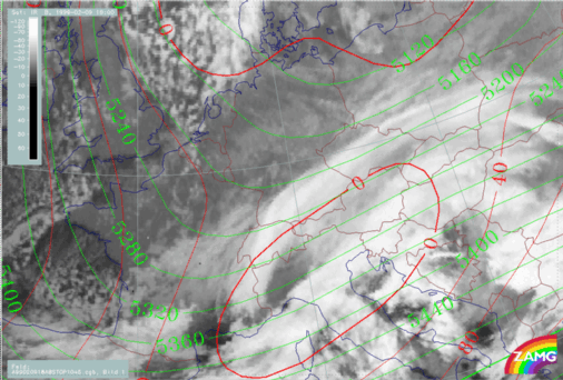
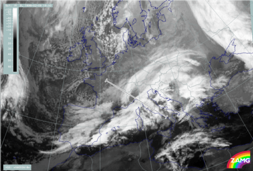
The typical example is from 09/12.00 UTC (where the frontal cloud band can be identified exactly over and north of the Alps) to 09/18.00 UTC (where the frontal cloud band is already south of the Alps extending from N. Italy to SE Austria). There are several typical cloud features that result from the propagation of a Cold Front band across the Alps from north to south:
- Cold Front cloud band south of Alps extending from SW to NE;
- Clearing to the lee of the Alps is especially marked in NW Italy;
- Cloud band immediately north of and within the Alpine mountain range, resembling an Occlusion - like cloud spiral; however, this band feature is the consequence of remnants of frontal cloudiness and Stau Cloud (partly formed by deformation).
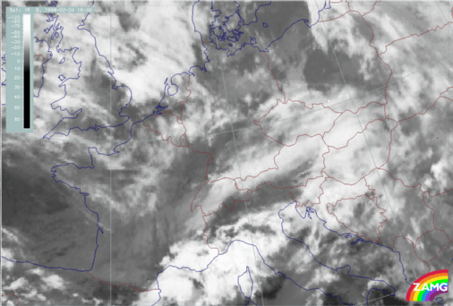
A second example from 20/18.00 UTC shows similar cloud features.
|
09 February 1999/12.00 UTC - Meteosat IR image; red: height contours 1000 hPa, green: height contours 500 hPa
|
09 February 1999/18.00 UTC - Meteosat IR image; red: height contours 1000 hPa, green: height contours 500 hPa
|
|
|
|
|
|
20 February 1999/18.00 UTC - Meteosat IR image
|
|
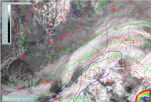
09 February 1999/12.00 UTC - Meteosat IR image; green: equivalent thickness 500/1000 hPa, red solid: temperature advection - WA 700 hPa, red
dashed: temperature advection - CA 700 hPa, blue: Thermal Front Parameter (TFP)
|
09 February 1999/18.00 UTC - Meteosat IR image; green: equivalent thickness 500/1000 hPa, red solid: temperature advection - WA 700 hPa, red
dashed: temperature advection - CA 700 hPa, blue: Thermal Front Parameter (TFP)
|
|
|
|
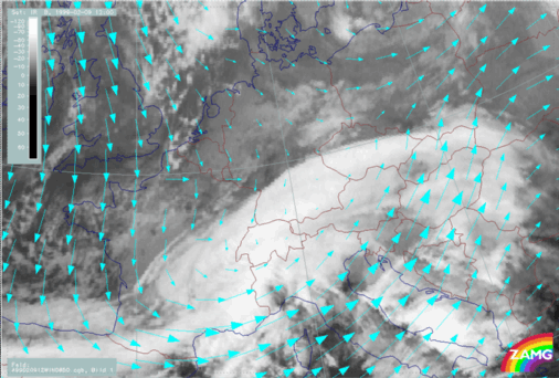
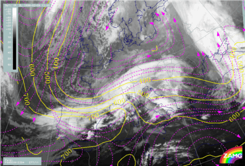
09 February 1999/12.00 UTC - Meteosat IR image; cyan: wind vectors 850 hPa
|
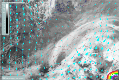
09 February 1999/18.00 UTC - Meteosat IR image; cyan: wind vectors 850 hPa
|
|
|
|
|
|
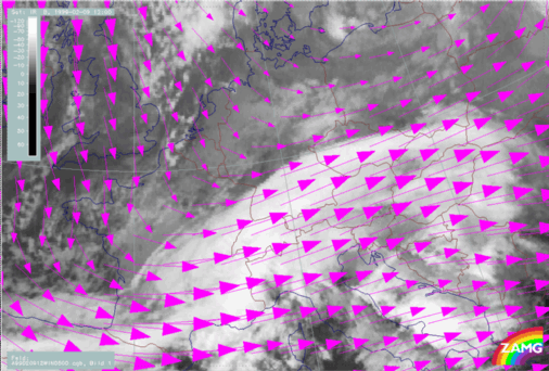
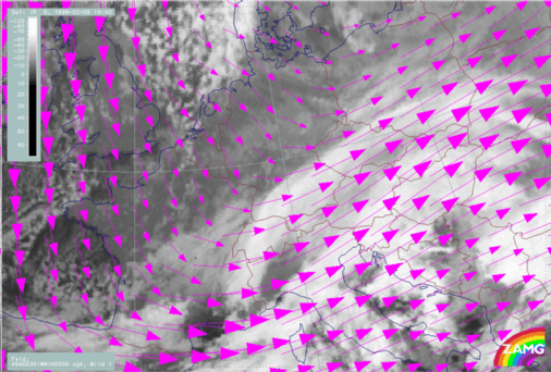
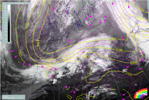
09 February 1999/12.00 UTC - Meteosat IR image; magenta: wind vectors 500 hPa
|
09 February 1999/18.00 UTC - Meteosat IR image; magenta: wind vectors 500 hPa
|
Over the area of Central and E. Alps the situation is somewhat different. At 850 hPa, there are small northerly components north of the Alps, especially over Bavaria, and rather strong southerly components south of the Alps accompanying the frontal cloud band. The latter might be responsible for the lower cloudiness over NE Italy and S. Austria. At 500 hPa, strong westerly components prevail. The form of the Occlusion - like Stau cloud is therefore a combination of several effects, namely Stau, descent and deformation at lower levels.
|
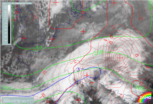
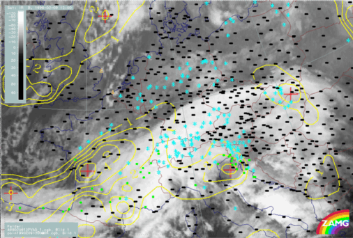
09 February 1999/12.00 UTC - Meteosat IR image; yellow: positive vorticity advection (PVA) 500 hPa; weather events (green: rain and showers, blue:
drizzle, cyan: snow, red: thunderstorm with precipitation, purple: freezing rain, orange: hail, black: no actual precipitation or thunderstorm with
precipitation)
|
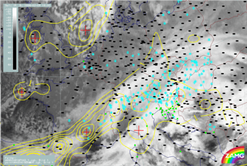
09 February 1999/18.00 UTC - Meteosat IR image; yellow: positive vorticity advection (PVA) 500 hPa; weather events (green: rain and showers, blue:
drizzle, cyan: snow, red: thunderstorm with precipitation, purple: freezing rain, orange: hail, black: no actual precipitation or thunderstorm with
precipitation)
|
|
|
As already mentioned in the chapter of the Comma and Comma crossing there are some reservations when using vertical cross sections in the region of the Alps, because of a lack of orography in the numerical model data as well as in the vertical cross section algorithm. Even so, remarkable results can be achieved by using this material.
|
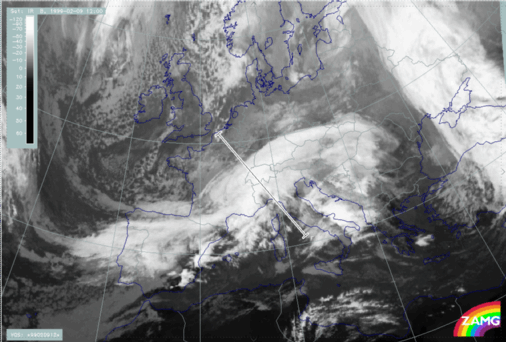
09 February 1999/12.00 UTC - Meteosat IR image; position of vertical cross section indicated
|
09 February 1999/18.00 UTC - Meteosat IR image; position of vertical cross section indicated
|
|

|
|
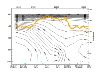
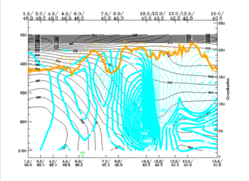
09 February 1999/12.00 UTC - Vertical cross section; black: isentropes (ThetaE), orange thin: IR pixel values, orange thick: WV pixel values
|
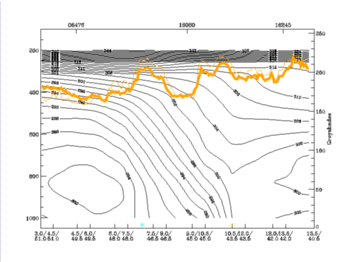
09 February 1999/18.00 UTC - Vertical cross section; black: isentropes (ThetaE), orange thin: IR pixel values, orange thick: WV pixel values
|
|
|
|
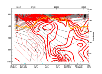
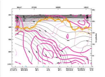
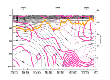
09 February 1999/12.00 UTC - Vertical cross section; black: isentropes (ThetaE), red thin: temperature advection - CA, red thick: temperature
advection - WA, orange thin: IR pixel values, orange thick: WV pixel values
|
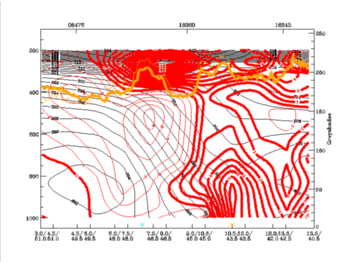
09 February 1999/18.00 UTC - Vertical cross section; black: isentropes (ThetaE), red thin: temperature advection - CA, red thick: temperature
advection - WA, orange thin: IR pixel values, orange thick: WV pixel values
|
|
|
- There is a rather classical distribution of TA around the frontal surface with WA in front and above, and CA below for both points in time; but:
- The CA propagates faster at higher levels and, therefore, lies above the WA layer at 18.00 UTC (750 - 500 hPa)
- The northern, weaker frontal zone (double structure in isentropes) is within CA and represents (if it is analysed separately at all) a Cold Front in Cold Advection
- There is a CA area above the upper level frontal zone at 400 hPa which indicates colder air already in advance of the frontal zone which intensifies between 12.00 and 18.00 UTC. This preceding CA maximum at high levels is a typical feature associated with a Cold Front or cold air systems crossing the Alps.
|
09 February 1999/12.00 UTC - Vertical cross section; black: isentropes (ThetaE), magenta thin: divergence, magenta thick: convergence, orange thin:
IR pixel values, orange thick: WV pixel values
|
09 February 1999/18.00 UTC - Vertical cross section; black: isentropes (ThetaE), magenta thin: divergence, magenta thick: convergence, orange thin:
IR pixel values, orange thick: WV pixel values
|
|
|
|
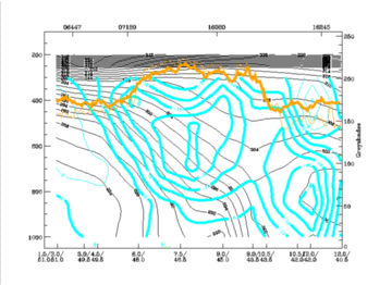
09 February 1999/12.00 UTC - Vertical cross section; black: isentropes (ThetaE), cyan thick: vertical motion (omega) - upward motion, cyan thin:
vertical motion (omega) - downward motion, orange thin: IR pixel values, orange thick: WV pixel values
|
09 February 1999/18.00 UTC - Vertical cross section; black: isentropes (ThetaE), cyan thick: vertical motion (omega) - upward motion, cyan thin:
vertical motion (omega) - downward motion, orange thin: IR pixel values, orange thick: WV pixel values
|
|
|
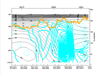
Another very pronounced effect, the lee clearing, is poorly represented in these cross sections: the location 45N/09E is quite representative of the area of the lee clearing, but vertical motion only shows smaller upward components and a very small area of positive values at the surface. But as the area of the "lee clearing" is quite small and the cross section F is more to the eastern part, close to the area of frontal cloudiness, a more western cross section G has been analysed.
|
09 February 1999/18.00 UTC - Meteosat IR image; position of vertical cross section indicated
|
09 February 1999/18.00 UTC - Vertical cross section; black: isentropes (ThetaE), cyan thick: vertical motion (omega) - upward motion, cyan thin:
vertical motion (omega) - downward motion, orange thin: IR pixel values, orange thick: WV pixel values
|
|
|
Concluding these discussions, from the information in the vertical cross section, an additional explanation can be inferred for the distinct form of the Occlusion - like band over the Alps: There is a second frontal structure contained in the total frontal system which might cause and/or intensify the cloudiness there. However, no parameter truly identifies an Occlusion system.
A study of relative streams adds information concerning the vertical structure of the frontal systems as well as the observed double structure.
For 12.00 UTC the surfaces of 300K and 304K represent the main frontal surface as well as the upper level front. For 18.00 UTC, the surfaces of 296K and 300K represent the main frontal system and 304K the upper level front.
|
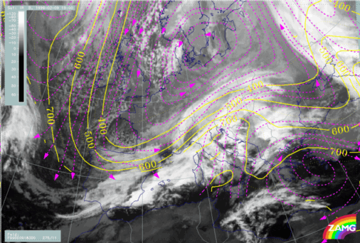
09 February 1999/12.00 UTC - Meteosat IR image; magenta: relative streams 300K - system velocity 277° 11 m/s; yellow: isobars
|
09 February 1999/12.00 UTC - Meteosat IR image; magenta: relative streams 304K - system velocity 277° 11 m/s; yellow: isobars
|
|
|
|
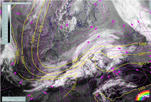
09 February 1999/18.00 UTC - Meteosat IR image; magenta: relative streams 300K - system velocity 275° 11 m/s; yellow: isobars
|
09 February 1999/18.00 UTC - Meteosat IR image; magenta: relative streams 304K - system velocity 275° 11 m/s; yellow: isobars
|
|
|
|
|
|
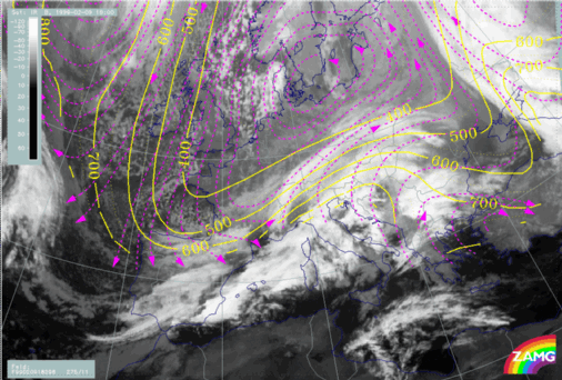
09 February 1999/18.00 UTC - Meteosat IR image; magenta: relative streams 296K - system velocity 275° 11 m/s; yellow: isobars
|
It can be concluded that the investigations of vertical cross sections and relative streams reveal Cold Fronts and their passage across the Alps quite well. However, smaller scale features, such as the lee clearing at 18.00 UTC, are not well represented.
Cold Front crossing without remarkable "Lee clearing"
There are cases where lee clearing cannot be obvserved.The typical synoptic situation can be summarized as:
- Cold Front crosses the Alpine region accompanied by a distinct thickness gradient
- WA changes to CA during the crossing over the Alps
- PVA existent but impact not clear
- Main cloud features: Cold Front band, Stau features
For the complete sequence of satellite images during this phase see Overview - Phase 9 .


