AVALANCHE CATASTROPHE 05 - 25 FEBRUARY 1999 - THICKNESS GRADIENT FORMING A TROUGH
by ZAMG
The typical synoptic situation can be summarised as:
- A thickness gradient forming a trough feature exactly over the Alpine area
- No frontal conditions (although a thickness gradient does exist)
- CA dominating
- There are phases where PVA plays an additional role
- Wind direction is mainly NW, throughout a deep layer of the troposphere
- Main cloud features: Stau features and also Lee features
05 February 1999/06.00 UTC - Meteosat IR image; green: equivalent thickness 500/1000 hPa, red solid: temperature advection - WA 700 hPa, red dashed:
temperature advection - CA 700 hPa, blue: Thermal Front Parameter (TFP)
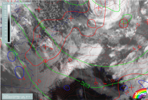
A typical example is the 06/06.00 UTC (phase 1 in chronological overview) which shows intensive Stau Cloud as well as some signs of Lee Cloud. A huge thickness
trough is situated over Germany and Central Europe, bound by a higher thickness gradient over the W. Alps. Since the zone of the thickness is rather broad, no fronts are indicated by a TFP line crossing the Alpine region. Despite an embedded WA maximum over France, the largest part of the trough is accompanied by CA with a maximum over the West Alps.
05 February 1999/06.00 UTC - Meteosat IR image; red: height contours 1000 hPa, green: height contours 500 hPa
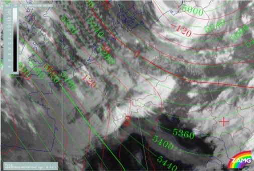
Whilst there are northerly directions in the surface flow (1000 hPa), the upper level flow at 500 hPa shows a distinct NW direction over the whole area of the Alps. In the West Alps, over Switzerland and France, the Stau Cloud is restricted to the mountain areas, whilst it extends somewhat to the north over Germany. It has to be noted that parallel cloud bands over S. Tyrol (Upper Italy) are rather parallel to the upper level stream. Such a phenomenon can be observed frequently and one possible explanation can be found in the development of high Lee Cloud fibres from single mountains.
|
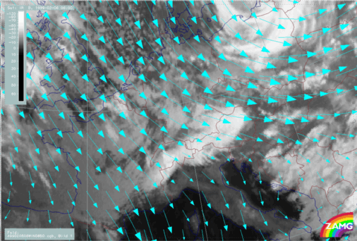
05 February 1999/06.00 UTC - Meteosat IR image; cyan: wind vectors 850 hPa
|
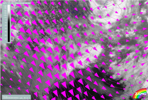
05 February 1999/06.00 UTC - Meteosat IR image; magenta: wind vectors 500 hPa
|
|
|
|
The cloud features so far described have a direct relationship with the wind fields. There is strong NWly flow from 850 up to 500 hPa becoming slightly more westerly over Central and East Austria. Consequently the wind blows almost perpendicularly to the mountain chains in the West as well as in East Alps. The abrupt end of the bright cloud is especially spectacular in Central and East Austria.
05 February 1999/06.00 UTC - Meteosat IR image; yellow: positive vorticity advection (PVA) 500 hPa; weather events (green: rain and showers, blue:
drizzle, cyan: snow, red: thunderstorm with precipitation, purple: freezing rain, orange: hail, black: no actual precipitation or thunderstorm with
precipitation)
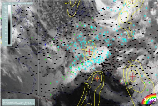
The presence of the Stau Cloud situation is well reflected in the many reports of snow over the whole Alpine mountain region, and also to the north, especially over Germany. Over S. Germany a PVA maximum can be linked to cloudiness and precipitation, although an intensification of both elements cannot be deduced from the data at this stage.
For the complete sequence of satellite images during this phase see
Overview - Phase 1
.