STORM CATASTROPHE 13 - 16 NOVEMBER 2001 - OVERVIEW OF GRAVITY WAVES
by FMI
Rapid Cyclogenesis on the leeside of Greenland
Rapid Cyclogenesis to the lee of Greenland is possible if stable stratified air is forced to rise over the Greenland shelf. Large amplitude gravity waves may form and their propagation upwards amplify, in part due to the decrease in atmospheric density. The upward wave propagation can subsequently result in overturning waves and turbulent breakdown. This can then result in deeper lower-troposheric adiabatic cooling.When this happens, the cold pool can grow as large as 500-1000 km in diameter in the layer 2-6 km above the surface. This kind of event took place over the Northern Atlantic when Janika was deepening. It can be seen in the loop below seen in the spreading of cold advection at 700 hPa. According to several theories the expansion of the cold pool can lead to the formation of a very strong jet stream.
Gravity waves and their appearance
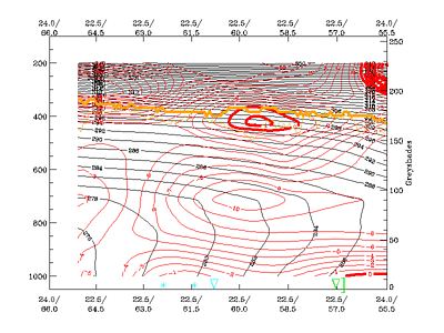
Common to all gravity waves is the fact that they occur in regions where weak mid-tropospheric static stability overlays a strong stable layer. Rapid amplification of waves typically occurs as they enter a region of highly stable cold air.Behind the southern and eastern edges of the gust front related to a gravity wave, a compact region of latent heating near the tropopause is often enclosed. A similar feature was observed in Finland associated with the passage of Janika. In the vertical cross sections on 16 November 2001 at 00.00 UTC a local maximum in WA appears and could be a sign of such a feature.
|
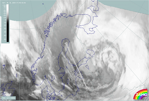
16 November 2001/00.00 UTC - Meteosat IR image; position of vertical cross section indicated
|
16 November 2001/00.00 UTC - Vertical cross section; black: isentropes (ThetaE), red: temperature advection, orange thin: IR pixel
values, orange thick: WV pixel values
|
|
|
- A polar Cold Front moves from the ocean over the land or
- A southward surge of arctic air takes place down the eastern side of a mountain range.
In water vapour imagery the waves can been seen as rapidly propagating, narrow 10-30 km and 500-1000 km long white arc lines. The absence of significant cloudiness makes them detectable primarily in the water vapour images.


