15 - 16 MARCH 1998 - 15.00 - 18.00 UTC - FRONTAL DIAGNOSIS - RELATIVE STREAMS AND CONVEYOR BELTS

by ZAMG


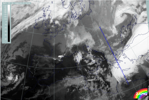
15 March 1998/18.00 UTC - Meteosat IR image; position of vertical cross section indicated
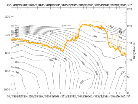
15 March 1998/18.00 UTC - Vertical cross section; black: isentropes (ThetaE), orange thin: IR pixel values, orange thick: WV pixel values
From the right image it can be seen that the isentropic surface of 298K is above the lower frontal zone and therefore characteristic of the low cloud area of the northern front, and that 308K is above the southern frontal zone.
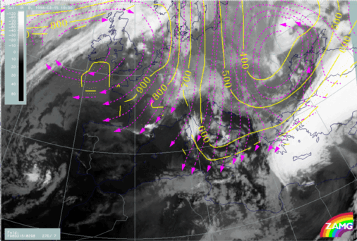
15 March 1998/18.00 UTC - Meteosat IR image; magenta: relative streams 298K - system velocity 270° 7 m/s, yellow: isobars
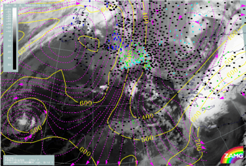
15 March 1998/18.00 UTC - Meteosat IR image; weather events (green: rain and showers, blue: drizzle, cyan: snow, red: thunderstorm with precipitation, purple: freezing rain, orange: hail, black: no actual precipitation or thunderstorm with precipitation), magenta: relative streams 308K - system velocity 284° 7 m/s, yellow: isobars
The situation on both isentropic surfaces at 18 UTC is nearly unchanged from 12.00 UTC (compare 09.00 - 12.00 UTC - Frontal Diagnosis - Relative streams and conveyor belts). There is a sinking dry intrusion from 500 down to 700 hPa over the low cloudiness of the northern frontal zone but intensive rising of a Warm Conveyor Belt over the Aegean Sea and Turkey which is also connected with an extended zone of precipitation. A limiting streamline between the rising warm wet stream from the south (Warm Conveyor Belt) and the sinking cold dry stream from the north (dry intrusion) can be found at the distinct northern and western cloud edges of the bright cloud band.

SUB-MENU OF 15 - 16 MARCH 1998
15.00 - 18.00 UTC - FRONTAL DIAGNOSIS - USE OF VERTICAL CROSS SECTIONS
15/21.00 - 16/00.00 UTC - OVERVIEW OF SATELLITE IMAGERY