15 - 16 MARCH 1998 - 06.00 UTC - OVERVIEW OF SATELLITE IMAGERY
by ZAMG
|
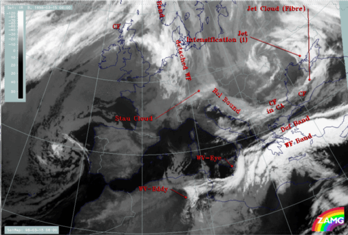
15 March 1998/06.00 UTC - Meteosat IR image; SatRep overlay: names of conceptual models
|
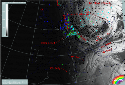
15 March 1998/06.00 UTC - Meteosat VIS image; weather events (green: rain and showers, blue: drizzle, cyan: snow, red: thunderstorm with
precipitation, purple: freezing rain, orange: hail, black: no actual precipitation or thunderstorm with precipitation), SatRep overlay: names
of conceptual models
|
|
|
|
|
|
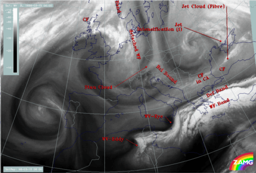
15 March 1998/06.00 UTC - Meteosat WV image; SatRep overlay: names of conceptual models
|
- A cloud band extending from Bulgaria across the Black Sea to the Ukraine; it accompanies a Cold Front (CF) which is to a big extent under the influence of cold advection (CA) (compare Conceptual Models: Cold Front );
- There is an area where the frontal cloudiness is intensified (Jet Intensification) by the crossing of a jet streak; this intensification happens in the left exit region of the jet streak (compare Conceptual Models: Front Intensification by Jet Crossing );
- A bright cloud band in the Mediterranean accompanying a Warm Front Band (WF band); there is some precipitation connected with the Warm Front Band in the Aegean Sea; no distinct cloud features of a Cold Front related to the Warm Front can be extracted (compare Conceptual Models: Warm Front Band );
- A narrow fibrous band named Deformation Band (DEF Band); extends parallel to the northern boundary of the Warm Front (compare Conceptual Models: Deformation Band );
- Two structures best seen in the WV image are named Water Vapour Eye (WV - Eye) and Water Vapour Eddy (WV - Eddy); they are represented by black, very dry circular features (compare Conceptual Models: Water Vapour Vortices ).

