12 - 13 NOVEMBER 1997 - THE PERIOD 12 NOVEMBER 21.00 UTC - 13 NOVEMBER 00.00 UTC

by ZAMG


Observational part

The last phase of this case study will show further very rapid convective developments at the leading edge of the Cold Front.
12 November 1997/21.00 UTC - Meteosat IR enhanced image
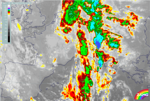
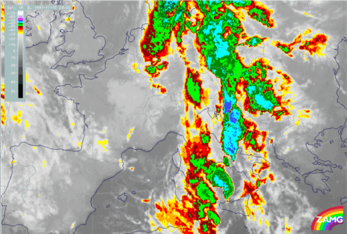
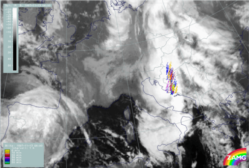
12 November 1997/21.00 UTC - Meteosat IR image; weather reports (green: rain and showers, blue: drizzle, cyan: snow, purple: freezing rain, red: thunderstorm with precipitation, orange: hail, black: no actual precipitation or thunderstorm with precipitation)
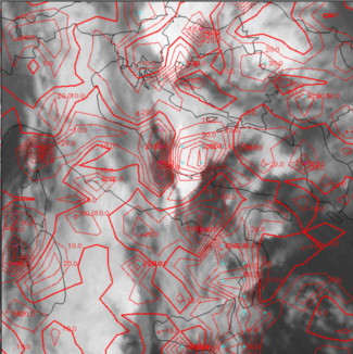
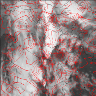
12 November 1997/21.00 UTC - Meteosat IR image; red: mean values of grey shades of cloud development and decay, cyan: cloud development greater than 30 units, magenta: cloud decay greater than 20 units
For 21.00 UTC the images show two huge convective systems with very cold tops over, respectively, Croatia (which is the continuation of the former phase Th3) and over central Italy and the Adriatic Sea (the latter has not yet been discussed and is named Th4); two typical oval-shaped cells with cold tops at the upstream edge can be located between Sardinia and Sicily (Th5). The Croatian cell Th3 is still connected with a lot of lightning and thunderstorm reports. Thunderstorms are also observed over Italy within Th4 (right image top). In the upstream edge of the Croatian MCS Th3, exactly where the lightning is reported, new cloudiness is still produced (left image bottom); and also the Italian cell Th4 is an area of strong new development.
12 November 1997/22.00 UTC - Meteosat IR enhanced image
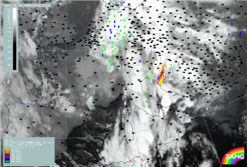
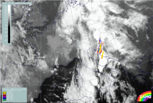
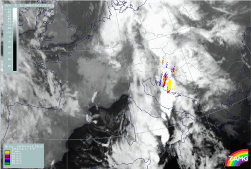
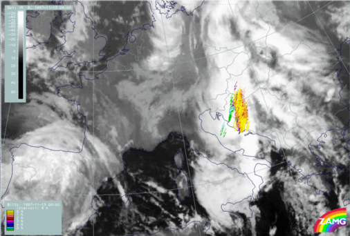
12 November 1997/22.00 UTC - Meteosat IR image; lightning reports
12 November 1997/22.00 UTC - Meteosat IR image; red: mean values of grey shades of cloud development and decay, cyan: cloud development greater than 30 units, magenta: cloud decay greater than 20 units
One hour later at 22.00 UTC the situation is as intensive as before; lightning reports have even increased, especially at the Croatian coast in connection with the propagating Italian MCS Th4. There is still a lot of new development connected with the systems Th3 and Th4 (left image bottom) and at this time a lot of new development has also taken place for the new cell north-west of Sicily (Th5).
12 November 1997/23.00 UTC - Meteosat IR enhanced image
12 November 1997/23.00 UTC - Meteosat IR image; lightning reports
12 November 1997/23.00 UTC - Meteosat IR image; red: mean values of grey shades of cloud development and decay, cyan: cloud development greater than 30 units, magenta: cloud decay greater than 20 units
Again one hour later at 23.00 UTC the situation with the two northern convective systems Th3 and Th4 is unchanged with a lot of lightning reports (left and right images top); a notable increase of area and colder cloud tops can be noticed with the system moving north of Sicily towards to the Italian west coast (Th5). The development image (left image bottom) shows notable new cloud development there. Looking at the sequence of images during the next hours it can be seen that this MCS approaches northward and reaches the Croatian coast and Bosnia at 06.00 UTC with widespread lightning reports (left and right images below).
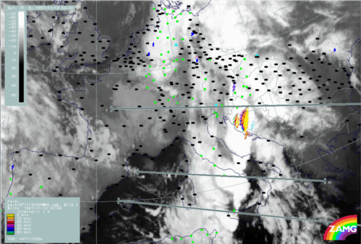
13 November 1997/06.00 UTC - Meteosat IR image; lightning reports

Synoptic environment part

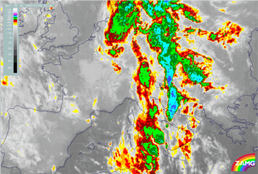
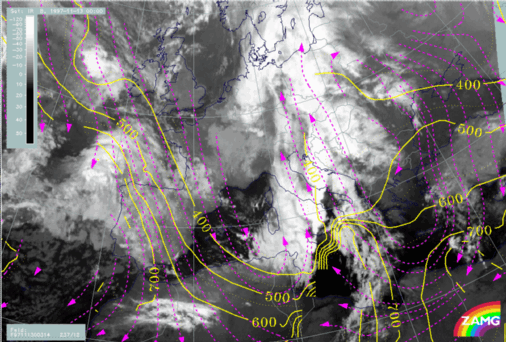
13 November 1997/00.00 UTC - Meteosat IR image; weather reports (green: rain and showers, blue: drizzle, cyan: snow, purple: freezing rain, red: thunderstorm with precipitation, orange: hail, black: no actual precipitation or thunderstorm with precipitation); position of vertical cross sections indicated
The image above shows the cloud situation at 13 November 00.00 UTC: the two convective systems Th3 and Th4 over Croatia, Bosnia and the Adriatic Sea have merged and are accompanied by a lot of lightning measurements and thunderstorm reports. Between the Italian south-west coast and north Sicily the MCS Th5a has increased; this cloud formation will reach Croatia and Bosnia six hours later. A smaller but well-shaped MCS can be seen close to west Sicily (Th5b). Three vertical cross sections illustrate the situation with the different MCSs and will be discussed later. It can be noticed that all MCSs are in one line from south-south-west to north-north-east and at the leading edge of the Cold Front cloud band. This can be supported by the relevant numerical parameters.
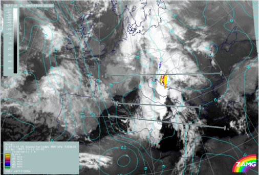
13 November 1997/00.00 UTC - Meteosat IR image; cyan: Showalter index 500/850 hPa, lightning reports; position of vertical cross section indicated
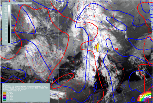
13 November 1997/00.00 UTC - Meteosat IR image; blue: thermal front parameter (TFP) 500/850 hPa, red: temperature advection 1000 hPa, lightning reports
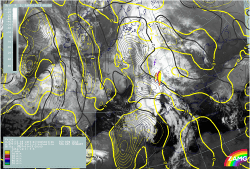
13 November 1997/00.00 UTC - Meteosat IR image; yellow: positive vorticity advection (PVA) 500 hPa, black: positive vorticity advection (PVA) 300 hPa, lightning reports
As the Showalter index indicates (left image top), there is a high probability of thunderstorms in this leading part of the cloud front band; the area with Showalter index <3 units is now, for the first time during the discussion period, smaller and more directly related to this part of the cloud band. All the cells and cell complexes are very close to the TFP line and, with the exception of the southernmost cell west of Sicily (Th5b), all are close to the transition between WA and CA (right image top). The latter mentioned cell Th5b is under the influence of CA and, contrary to the other cells, in direct connection with PVA maxima aloft (left image bottom).

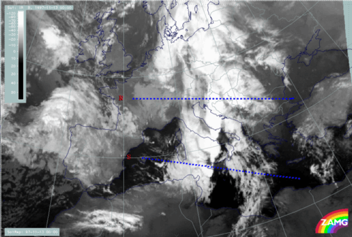
These differences can also be noticed in the vertical cross sections. The northern vertical cross section R through the Croatian MCS Th3 + Th4 is compared to the southern cross section S across the smaller convective system Th5b west of the WA area.

13 November 1997/00.00 UTC - Meteosat IR image; position of vertical cross sections S and R indicated
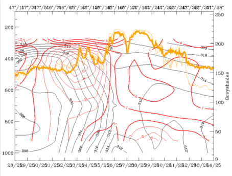
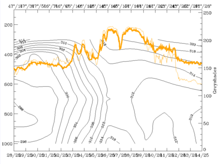
13 November 1997/00.00 UTC - Vertical cross section R; black: isentropes (ThetaE), red thin: temperature advection - CA, red thick: temperature advection - WA, orange thin: IR pixel values, orange thick: WV pixel values
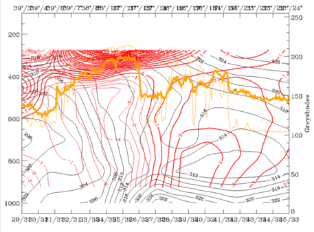
13 November 1997/00.00 UTC - Vertical cross section S; black: isentropes (ThetaE), red thin: temperature advection - CA, red thick: temperature advection - WA, orange thin: IR pixel values, orange thick: WV pixel values
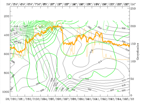
13 November 1997/00.00 UTC - Vertical cross section S; black: isentropes (ThetaE), green thick: vorticity advection - PVA, green thin: vorticity advection - NVA, orange thin: IR pixel values, orange thick: WV pixel values
The left and right top images show isentropes and temperature advection. Both convective systems can be identified by the maximum in the satellite signals and by the thunderstorm report. In both cross sections the frontal zones can be discriminated easily and the thunderstorms appear with the frontal zone. But the northern frontal zone has a much deeper layer with superadiabatic inclination than the southern one. Besides this the WA in the lower layer is only involved in the northern cross section, while the thunderstorm in the southern one occurs in an area of CA reaching into high levels. This latter fact is compensated for by an increase of PVA with height as can be seen in the bottom left image.
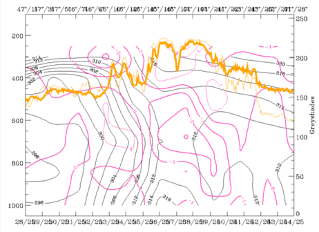
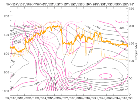
13 November 1997/00.00 UTC - Vertical cross section R; black: isentropes (ThetaE), magenta thin: divergence, magenta thick: convergence, orange thin: IR pixel values, orange thick: WV pixel values
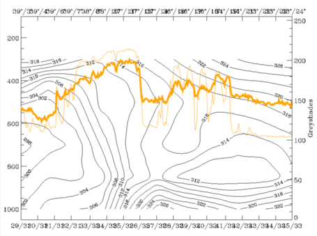
13 November 1997/00.00 UTC - Vertical cross section S; black: isentropes (ThetaE), magenta thin: divergence, magenta thick: convergence, orange thin: IR pixel values, orange thick: WV pixel values
The images above finally show that in both cases there is a layer of notable convergence but again there are differences between the two cases. For the northern MCS maximal convergence exists in the middle troposphere ahead of the front, while for the southern cell it is the convergence cell within the front which causes high convergence in the lower and middle layers.
13 November 1997/00.00 UTC - Vertical cross section R; black: isentropes (ThetaE), orange thin: IR pixel values, orange thick: WV pixel values
13 November 1997/00.00 UTC - Vertical cross section S; black: isentropes (ThetaE), orange thin: IR pixel values, orange thick: WV pixel values
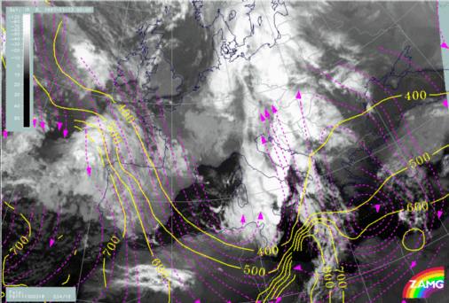
13 November 1997/00.00 UTC - Meteosat IR image; magenta: relative streams 314K - system velocity 237° 12 m/s, yellow: isobars
13 November 1997/00.00 UTC - Meteosat IR image; magenta: relative streams 316K - system velocity 234° 12 m/s, yellow: isobars
Finally, two isentropic surfaces repeat a situation which has already been mentioned in the SatRep diagnosis for this time (compare Synoptic Situation for 13 November 00.00 UTC). On ThetaE 314K (left image) the fast-growing cell between Sicily and Italy coincides with a Warm Conveyor Belt. On ThetaE 316K (right image) it is already the drier relative stream from behind. This is not only a typical frontal situation causing lability but might be an explanation in this case for the sudden and fast development of the MCSs in this area. Because of a change in the jet situation between 12/18.00 UTC and 13/00.00 UTC with the development of a new jet streak over Tunisia and further eastward, the relative streams from behind the front moved into the area ahead of the frontal cloud band.

SUB-MENU OF 12 - 13 NOVEMBER 1997
THE PERIOD 12 NOVEMBER 14.00 - 18.30 UTC
SOME SUMMARIZING IDEAS