24 - 30 SEPTEMBER 1997 - DISSOLUTION STAGE AND CONCLUSIONS
by KNMI
Synoptic situation
In the dissipation stage, warmer moister air enters the core of the ULL. This process leads to a decrease of temperature gradient and, hence, to the dissipation of the ULL.|
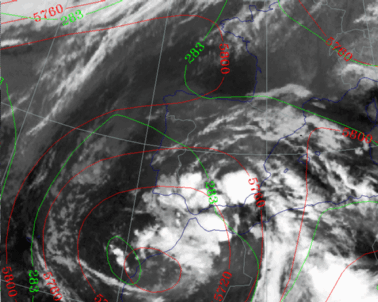
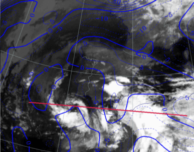
29 September 1997/00.00 UTC - Meteosat IR image; green: equivalent thickness 500/850 hPa, red: height contours 500 hPa
|
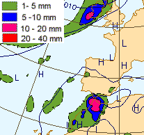
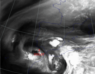
29 September 1997/00.00 UTC - Surface chart; accumulated precipitation 12.00 - 00.00 UTC
|
|
|
The system can also be found on the surface chart, which is seen as a low over the Moroccan region. This is in contrast to the earlier stages, in which the ULL was hard to find on the surface chart, also indicating that the ULL is in its dissipation stage. However, the amount of accumulated precipitation continues to be substantial over the Gibraltar area, caused by MCSs and CB clusters in unstable air.
29 September 1997/00.00 UTC
Analysis of the system|
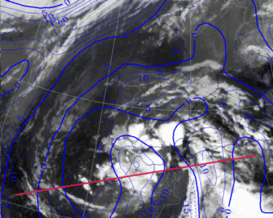
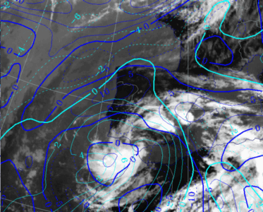
29 September 1997/00.00 UTC - Meteosat IR image; blue: thermal front parameter (TFP) 500/850 hPa; position of vertical cross section indicated
|
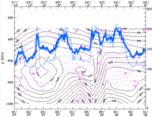
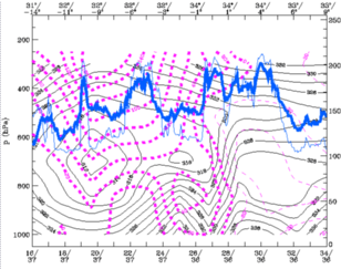
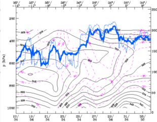
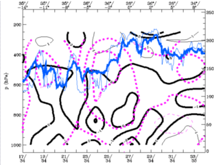
29 September 1997/00.00 UTC - Vertical cross section; black: isentropes (ThetaE), magenta: relative humidity, blue thin: IR pixel
values, blue thick: WV pixel values
|
|
|
- The isentropes are characterised by a decreasing ridge structure which represents a decrease of the temperature gradient. The isentropes of equivalent potential temperature are showing increasing values in the centre of the ULL.
- The relative humidity shows a complex pattern with different maxima. A pronounced relative humidity maximum can be found at 3605E-3408E at around 600 hPa. This maximum coincides with the peaks in the pixel values of the WV and IR image and indicates the old CF band that is spiralling around the ULL.
- Another relative humidity maximum can be found in the layer 700-800hPa, near to the centre of the ULL at 3605W. This maximum is increasing, which means that moist air is entering the core of the ULL. The relationship with the IR and WV signal is less clear in this case.
|
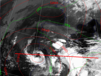
29 September 1997/00.00 UTC - Meteosat IR image; blue: thermal front parameter (TFP) 500/850 hPa, cyan: vorticity 500 hPa; position of vertical
cross section indicated
|
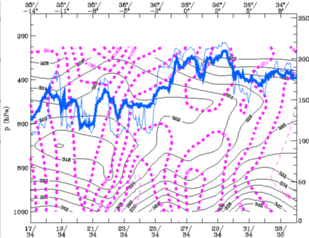
29 September 1997/00.00 UTC - Vertical cross section; black: isentropes (ThetaE), magenta: relative vorticity, blue thin: IR pixel
values, blue thick: WV pixel values
|
|
|
Low level vorticity can also be found, in contrast to previous stages. This indicates that the system is extending to the lower levels of the troposphere.
|
29 September 1997/00.00 UTC - Meteosat IR image; red: height of PV=2 units
|
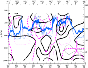
29 September 1997/00.00 UTC - Vertical cross section; black: isentropes (ThetaE), magenta: relative vorticity, blue thin: IR pixel
values, blue thick: WV pixel values
|
|
|
The height of PV = 2 is increasing, which indicates a warming of the air in the centre of the ULL.
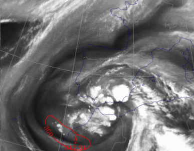
In the cross section, a pronounced area of vertical motion can be seen which coincides with the unstable airmass that appears to the right side of the ULL over the coastline of NW Morocco.
30 September 1997/00.00 UTC
|
30 September 1997/00.00 UTC - Meteosat IR image; blue: thermal front parameter (TFP) 500/850 hPa; position of vertical cross section indicated
|
30 September 1997/00.00 UTC - Vertical cross section; black: isentropes (ThetaE), magenta: relative vorticity, blue thin: IR pixel
values, blue thick: WV pixel values
|
|
|
The isentropes of equivalent potential temperature are showing increasing values in the centre of the ULL. The Equivalent Potential Temperature has increased by 6K in the core of the ULL.
Two maxima of relative humidity can be found. This indicates the old frontal cloud band, which has spiralled around the ULL. It can also be seen that moister air enters the core of the ULL, further indicating the dissipation of the ULL. However the relationship between the WV and IR pixel values is not easily seen. It seems that the system iis not well detected by the numerical model.
|
30 September 1997/00.00 UTC - Meteosat IR image; green: equivalent thickness 500/850 hPa, red: height contours 500 hPa; position of vertical
cross section indicated
|
30 September 1997/00.00 UTC - Vertical cross section; black: isentropes (ThetaE), magenta: relative humidity, blue thin: IR pixel
values, blue thick: WV pixel values
|
|
|
Values of upper air vorticity are decreasing, indicating a weakening of the cyclonic circulation. Remarkably, the vorticity at lower levels is increasing, which means that the lower level system is becoming more pronounced (See also Synoptic Situation).
|
30 September 1997/00.00 UTC - Meteosat IR image; red: height of PV=2 units
|
30 September 1997/00.00 UTC - Vertical cross section; black: isentropes (ThetaE), magenta: relative humidity, blue thin: IR pixel
values, blue thick: WV pixel values
|
|
|
A pronounced maximum of vertical velocity can be detected at 500 hPa. This maximum doesn't coincide with the maximum pixel values of the WV and IR. Again, the numerical model does not detect the situation well.
Conclusions
The Upper Level Low, as analysed here, is a classical type and has all the characteristics of the Conceptual Model described in the Manual.In this case the reactivation of an already existing Upper Trough west of Portugal by a fast moving unstable Wave from the west, known in literature as "trigger", was important. This was most significant at the top of the troposphere. This trough part of the Wave brought a new injection of cold, descending air with stratospheric origin. The merging of the two troughs was the start of the tear-off/cut-off process.
Cold air was transported around the centre of the ULL and met warm continental air over the Iberian Peninsula and north-west Africa. The advection of cold air was most pronounced at upper levels and therefore instability was increasing during the process. The "clash" with the warmer continental air not only caused frontogenisis, but was also the start of heavy convective activity in forms of CBs, CB clusters and MCS triggered by convergence in the baroclinic zones. This process persisted for several days, especially the cut-off and dissipation stages. Most of the precipitation occurred in the dissipation stage and was caused by (embedded) showers from an MCS and, therefore, the amount of precipitation differed significantly from place to place. Most of the precipitation was concentrated over north Morocco and southern Spain. Model forecasts for the amounts and location of rainfall were very inconsistent as is often the case with convective precipitation. During the cut-off stage the descending troposheric air with high PV values came to its lowest level with the tropopause just above 400hPa in the centre of the ULL.
The sinking air was responsible for diabatic heating and is one of the reasons for the "filling" of the low.
Another reason was the horizontal advection of moist and warmer air which spiralled into the centre whilst releasing latent heat in the condensation process. During the whole life cycle the vorticity extended more and more down in the troposphere and in the dissipation stage a surface low appeared below the centre of the ULL.
References
- BADER M. J., FORBES G. S., GRANT J. R., LILLEY R. B. E. and WATERS A. J. (1995): Images in weather forecasting - A practical guide for interpreting satellite and radar imagery; Cambridge University Press
- BLUESTEIN H.B. Synoptic Dynamic Meteorology in Midlatitudes - Volume I Principles of Kinematics and Dynamics; Oxford University Press.
- BLUESTEIN H.B. Synoptic Dynamic Meteorology in Midlatitudes - Volume Obeservations and Theory of Weather Systems; Oxford University Press.
- HOSKINS B. J., MCINTYRE M. E. and ROBERTSON A. W. (1985): On the use and significance of isentropic potential vorticity maps; Quart. J. R. Meteor. Soc., Vol. 111, p. 877 - 946
- HOSKINS B. J. (1991): Towards a PV - Theta view of the general circulation; Tellus, Vol. 43 AB, p. 27 - 35
- MARTIN F., ELIZAGA F., RIOSALIDO R., Servicio de Tecnicas de Analisis y Prediccion (STAP) Instituto Nacional de Meteorologia (INM), C/Paseo de las Moreras s/n, Ciudad Universitaria, Madrid E_28071, Spain (1999): The Mushroom configuration in water vapour imagery and operational applications. Meteorol. Apl. 6 143-154 (1999)

