29 JULY 1997 - THE EASTERN CLOUD SYSTEM
by ZAMG
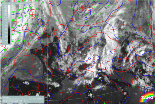
29 July 1997/12.00 UTC - Meteosat IR image; red: divergence 850 hPa, blue: divergence 700 hPa, green: wind vectors 850 hPa
The eastern, relatively stationary cloud system is still accompanied by convergence in a thick layer (divergence at 850 hPa - red, divergence at 700 hPa - blue) and there is still the confluence of the wind vectors in the low layer (compare
Diagnosis of the eastern cloud feature - Conceptual models "Convergence Cloudiness" and "Cumulonimbus (Cb) and Mesoscale Convective System (MCS)"
).
SUB-MENU OF 29 JULY 1997
THE WESTERN CLOUD SYSTEM
INSTABILITY 12.00 UTC