29 JULY 1997 - DIAGNOSIS OF THE WESTERN CLOUD FEATURE - CONCEPTUAL MODEL "FRONT INTENSIFICATION BY JET CROSSING"
by ZAMG
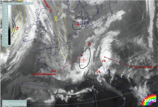
29 July 1997/06.00 UTC - Meteosat WV image; yellow: isotachs 300 hPa, black: shear vorticity 300 hPa; SatRep overlay: names of conceptual models
The image above contains some jet streak features superimposed on the WV image. The black line is the zeroline of shear vorticity at 300 hPa and represents the jet axis, the yellow lines are isotachs at 300 hPa. From the WV image a first guess about the jet axis can be found with help of the fibres extending from the North Sea into France, and also with help of the darker areas on the cyclonic side of the jet axis representing sinking dry air. Of special interest is the darkest area centred over east France (around 48N/07E) which represents dry air on the rear side of the western cloud band. The numerical model is in relatively good agreement with the cloud features concerning the jet axis (some small misplacements between cloud fibre and zeroline can be noticed but are of minor importance).
|
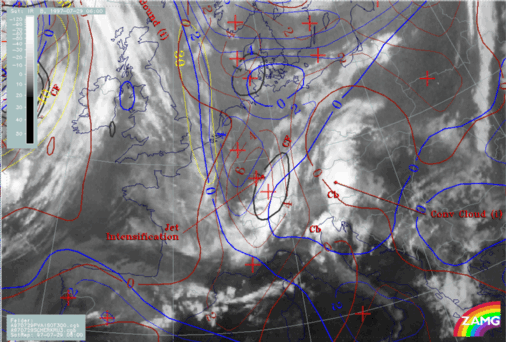
29 July 1997/06.00 UTC - Meteosat IR image; black: positive vorticity advection (PVA) 300 hPa, yellow: isotachs 300 hPa; SatRep overlay: names of
conceptual models
|
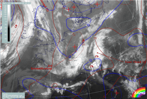
29 July 1997/06.00 UTC - Meteosat IR image; yellow: isotachs 300 hPa, blue: shear vorticity 300 hPa, brown: curvature vorticity 300 hPa; SatRep overlay:
names of conceptual models
|
|
|
|
|
|
|
|
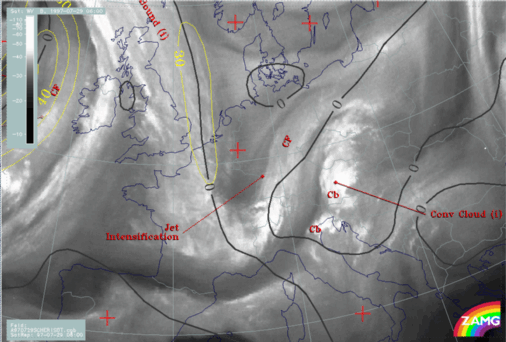
29 July 1997/06.00 UTC - Meteosat IR image; blue: shear vorticity 500 hPa, dark red: curvature vorticity 500 hPa; SatRep overlay: names of conceptual
models
|
|
The top left image adds information about the relation between jet streak, its left exit region and the cloudiness with help of the isotachs (yellow) and the PVA maximum (black) at 300 hPa. Although the isotach maximum of 30 m/s is rather weak, there is a maximum of PVA in the left exit region in exact agreement with the intensified cloud area over Switzerland and south Germany. In the top right image the contributions of the jet streak and the upper level trough can be evaluated with help of shear (blue) and curvature (brown) vorticity. Clearly both effects are important: there is a maximum of shear as well as of curvature vorticity connected with the PVA maximum. From the bottom left image, which gives similar information for 500 hPa, it can clearly be seen that at this level only the propagating trough contributes to the PVA maximum and the cloudiness. Therefore at the higher level of 300 hPa the propagating jet streak enhances PVA and cloudiness.
From these considerations the western cloud feature can be diagnosed as cloudiness produced and maintained by processes in the upper levels: a propagating upper level trough existing in a thick layer and a jet streak with a left exit region only in the higher layers.