19 FEBRUARY 1997 - KEY PARAMETERS ON ISOBARIC SURFACES FOR RAPID CYCLOGENESIS 00.00 UTC
by ZAMG
As satellite imagery cannot support and localise a conceptual model
Rapid Cyclogenesis alone, the other relevant key parameters of the conceptual model have to be inspected: numerical parameters on isobaric surfaces. Three parameter combinations are relevant for such a physical situation:
- The typical Wave parameters like surface low, WA maximum and PVA maximum at 500 hPa: in the case of Rapid Cyclogenesis all parameters
indicating a Wave development should also be well developed;
- The jet situation at 300 hPa: in the case of Rapid Cyclogenesis, a jet streak with sinking dry air at the cyclonic side and a PVA
maximum in the left exit region over the cloud head area can be expected;
- The vertical distribution of potential vorticity (PV) shows very dry, sometimes even stratospheric air, down to heights of 400 - 500
hPa; the most convenient key parameter for this is the height of PV = 2 units a threshold which is regarded as the transition
from tropospheric to stratospheric air.
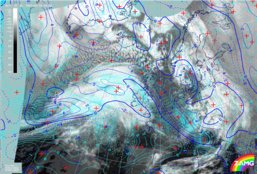
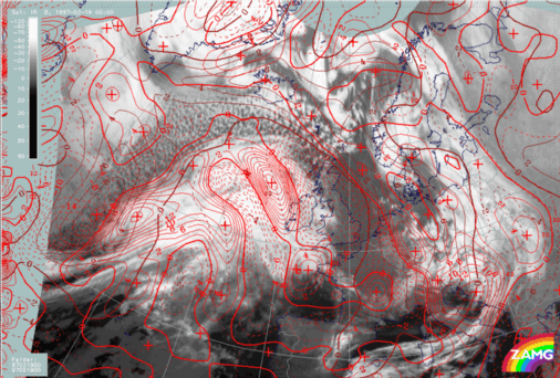
19 February 1997/00.00 UTC - Meteosat IR image; magenta: height contours 1000 hPa, green: positive vorticity advection (PVA) 500 hPa,
red: temparature advection - WA 1000 hPa
The image above includes the group of wave parameters. A pronounced surface low (1000 hPa) as well as a WA maximum accompany the north-eastern of the two cloud bulges and thus support a Wave development there. In contrast, the PVA maximum at 500 hPa belonging to this area is rather weak and its relation to the Wave is somewhat unclear. There is a second much better developed PVA maximum at the rear of the south-western cloud bulge. This latter cloud structure has some features of a Comma but is connected with the frontal cloudiness instead of being separated within the cold air. So up to now this case shows several similarities with the conceptual models
Wave (compare
Conceptual Models: Wave
),
Rapid Cyclogenesis (compare
Conceptual Models: Rapid Cyclogenesis
)
and
Comma (compare
Conceptual Models: Comma
) in this region.
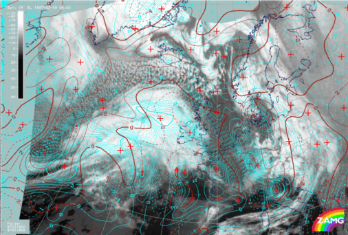
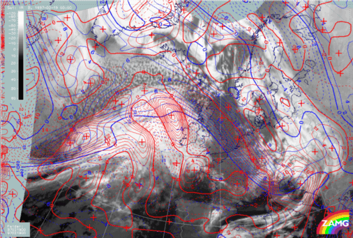
19 February 1997/00.00 UTC - Meteosat IR image; green: positive vorticity advection (PVA) 300 hPa, yellow: isotachs 300 hPa
The image above adds the jet streak information which at first glance unfortunately complicates the situation instead of resolving it. There are three jet streaks:
- An intensive one at the leading edge of the Warm Front cloud shield over the British Isles; it is not involved in the Rapid
Cyclogenesis process;
- A smaller one in the area of the north-eastern cloud bulge which is not clearly related to the cloudiness but might be responsible
for the substructure in the WV imagery;
- A distinct one at the rearward edge of the Cold Front immediately south of the Comma - like feature; this jet streak might be
connected with the Rapid Cyclogenesis, too.
The PVA maxima do not have any distinct connection to a left exit region of any of these jet streaks. Therefore a more detailed analysis of these PVA maxima has to be done. Such a situation appears from time to time and one tool for getting a better overview of the synoptic situation is the separate use of shear and curvature vorticity.
Hints for difficult PVA field interpretation
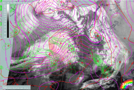
19 February 1997/00.00 UTC - Meteosat IR image; red: vorticity advection 300 hPa, brown: curvature vorticity 300 hPa
The image above shows the PVA field at 300 hPa together with curvature vorticity at this level. With this combination the two north-south oriented PVA lobes parallel to the Warm Front and within the warm sector can be sorted out. They exist in wide areas of anticyclonic vorticity and represent regions where it becomes less anticyclonic. Up to now no distinct synoptic meaning and reflectance is known with those situations. The most pronounced cyclonic phenomenon is the curvature maximum at the rear of the south-western cloud bulge. This fits nicely to the conceptual models of upper level features like Commas with a maximum of curvature vorticity causing a spiral structure and a PVA maximum which is maintaining and/or intensifying cloudiness.
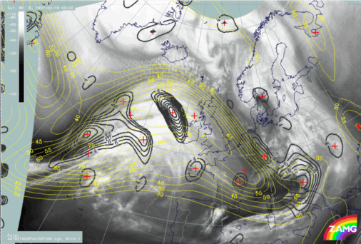
19 February 1997/00.00 UTC - Meteosat IR image; red: vorticity advection 300 hPa, blue: shear vorticity 300 hPa
The image shows the connection between PVA and shear vorticity at 300 hPa. There are two maxima of shear vorticity close to the rearward edges of the two cloud bulges. The northern one does not seem to have a distinct connection to the Rapid Cyclogenesis which is supposed to be connected with the north-eastern cloud bulge; the south-western shear vorticity maximum is very close to the curvature maximum there (compare the first image on this page) but has a much bigger south-west - north-east orientation. Consequently the north-easternmost part of the relevant PVA lobe seems to best correspond to the area of Rapid Cyclogenesis.
|
19 February 1997/00.00 UTC - Meteosat IR image; red: vorticity advection 500 hPa, blue: shear vorticity 500 hPa
|
19 February 1997/00.00 UTC - Meteosat IR image; red: vorticity advection 500 hPa, brown: curvature vorticity 500 hPa
|
|
|
|
The images above leave the jet level and show shear and curvature vorticity at 500 hPa. The results are the same as for 300 hPa but are even more distinct.
Summarizing the outcome of satellite images and numerical model parameters, till now a conceptual model Rapid Cyclogenesis in the north-eastern cloud bulge and a conceptual model Comma (-like) in the south-western cloud bulge can be supported. Shear and curvature vorticity (although close together) show different orientation and therefore the PVA maxima related to them influence the different cloud areas.