02 - 03 JUNE 2000 - JET STREAK AND VORTICITY ADVECTION
by ZAMG
Jet streak and Vorticity Advection
|
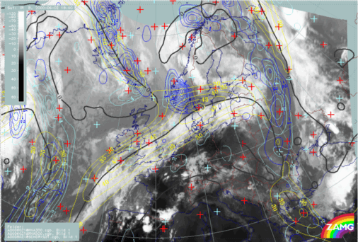
02 June 2000/18.00 UTC - Meteosat IR image; blue: negative vorticity advection (NVA) 500 hPa, cyan: negative vorticity advection (NVA) 300 hPa,
yellow: isotachs 300 hPa, black: shear vorticity 300 hPa
|
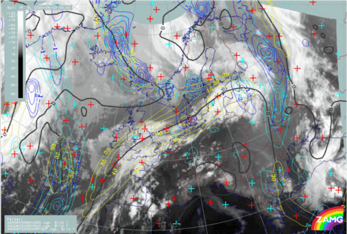
03 June 2000/00.00 UTC - Meteosat IR image; blue: negative vorticity advection (NVA) 500 hPa, cyan: negative vorticity advection (NVA) 300 hPa,
yellow: isotachs 300 hPa, black: shear vorticity 300 hPa
|
|
|
|
|
|
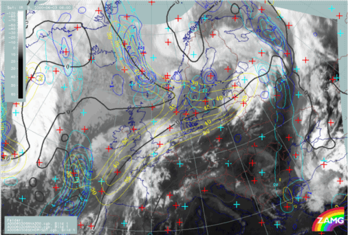
03 June 2000/06.00 UTC - Meteosat IR image; blue: negative vorticity advection (NVA) 500 hPa, cyan: negative vorticity advection (NVA) 300 hPa,
yellow: isotachs 300 hPa, black: shear vorticity 300 hPa
|
On 02 June 2000/18.00 UTC, isotachs at 300 hPa show a pronounced jet streak along and parallel to the rear edge of the frontal cloud band. There are several weak maxima of negative vorticity advection at 300 hPa and 500 hPa. NVA associated with sinking motion can be observed in the right exit region of a secondary jet streak maximum over Great Britain.
By 00.00 UTC the NVA maxima at 500 hPa and 300 hPa become more distinct over the cloud gap. This is the time when cloud dissipation starts. The most of the cloud gap is positioned near the anticyclonic side of the jet axis.
By 06.00 UTC there is still an NVA maximum at 500 hPa and a distinct NVA maximum at 300 hPa, extending from the rear of the front into a large cloud gap. A jet streak maximum is also positioned above the northern boundary of the cloud dissipation zone.
The appearance of these parameters also supports the physical concept of Front Decay, but from a different point of view.


