Detached Warm Front - Cloud Structure In Satellite Images
by ZAMG
- The satellite image shows a meso- to synoptic scale cloud field of multilayered cloudiness mostly with a sharp edge along the cyclonic side.
- There is a typical relationship between this cloud field and the upstream frontal system: the cloud field of the Detached Warm Front can be found separated and downstream from the cloudiness of a classical frontal system.
- Height and thickness contours accompany these configurations with pronounced ridges bound by zones with strong gradients of the isolines (see Key parameters); the Detached Warm Front cloudiness can be found in the eastern downstream branch.
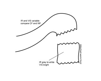
- In the VIS image the cloud field of the Detached Warm Front is white, indicating lower multilayered cloudiness.
- In the IR image the grey shades vary typically between light grey and grey; high pixel values can mostly be found at the cold side of the thickness gradient (leading area of the frontal cloudiness).
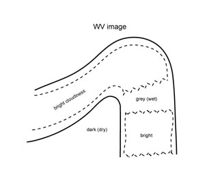
- The WV image shows a wide broad anticyclonic curved area with high WV pixel values, indicating high moisture content within the gradient zones surrounding the equivalent thickness ridge.
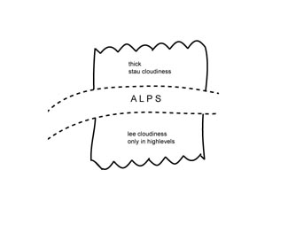
- A typical area for the occurrence of Detached Warm Fronts is the windward side of the Alps, being accompanied by
increased weather activity (see Weather events):
if the Detached Warm Front moves against mountains (for instance in central Europe against the Alps), enhanced cloudiness, Barrage Cloudiness, can be found at the windward side (see Barrage Cloud ), as well as high Lee Cloudiness at the lee side (see Lee Cloudiness ). - Some features of a life cycle can be observed:
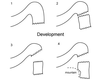
- Often the cloudiness of the Detached Warm Front moves downstream from a classical Warm Front system and becomes an independent system.
- It mostly propagates southward, leading to a movement against the Alps in central Europe.
- In the case of a Detached Warm Front on the windward side of the Alps a typical feature can be observed if the whole ridge system moves eastward. In this case, that part of the high cloudiness of the Detached Warm Front reaching the eastern edge of the Alps propagates quickly southward while the rest of the cloudiness is still bounded by the mountain chain.
- During its lifetime high level cloudiness often dissolves so that IR grey shades become darker.
|
|
|
|
|
|
|
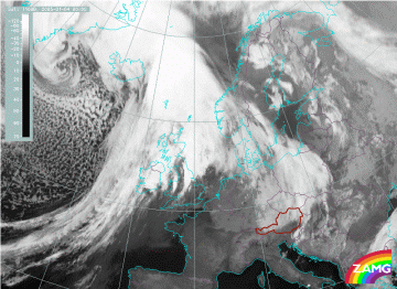
04 January 2005/00.00 UTC - Meteosat 8 IR 10.8 image
|
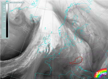
04 January 2005/00.00 UTC - Meteosat 8 WV6.2 image
|
|
|
The IR image shows bright grey shades indicative of the initial stage of the life cycle, with the brightest grey shades in the centre and at the leading edge which is nearly in accordance with the description of the ideal situation. The sudden decrease of the pixel values along the leading edge fits with the superimposed jet at approximately 300 hPa. The boundary of white to dark grey characterizes the jet axis.
In the WV image the separation between WF shield and Detached Warm Front can be clearly seen. Greyer value pixels are all located over southern Norway, Denmark and eastern Germany. An interesting and dominant feature in the WV image is the black, dry stripe from central Sweden over the Baltic Sea into the Baltic States and then further south into Serbia. It is an indication of the anticyclonic circulation within an upper level ridge.
|
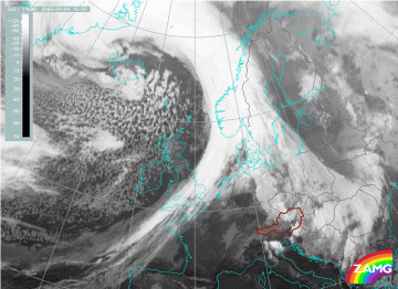
04 January 2005/12.00 UTC - Meteosat 8 IR 10.8 image
|
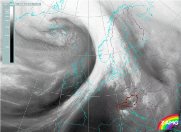
04 January 2005/12.00 UTC - Meteosat 8 WV 6.2 image
|
|
|
|
|
|
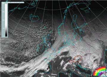
04 January 2005/12.00 UTC - MSG VIS 0.6 image
|
In the WV image the detached cloudiness is seen as grey indicating less moisture. The WV dark stripe on the anticyclonic side is still very much noticeable.
The IR loop shows the development of the Detached Warm Front. Special attention should be paid at the time when the Detached Warm Front hits the Alps. As it then wanders eastward, more cloudiness penetrates southward on the eastern edge of the Alps over Slovenia.


