Detached Warm Front - Meteorological Physical Background
by ZAMG
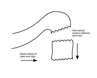
In the case of an eastward moving classical frontal system the Detached Warm Front is mostly observed within the eastern branch of a pronounced synoptic scale ridge in the height and thickness fields, accompanied by strong winds in higher levels of the troposphere (approximately at 500 hPa) which blow normal to the movement of the ridge system.
A possible and often observed indication for the formation of a Detached Warm Front is a splitting of the wind field within the mid- and upper levels of the troposphere in the area of the Warm Front into a north-western and a strong southern stream. This causes the cloud field of the Detached Warm Front to move more or less rapidly southward within the eastern branch of the upper level ridge which is, in this case, very close to the high gradient zone of equivalent thickness. The original frontal system, which is situated further north, moves from west to east. Consequently the different air streams cause two WA maxima. WA maxima contribute to upward motion which is one reason for the maintenance of cloudiness.
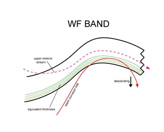
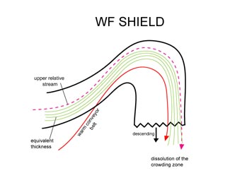
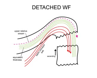
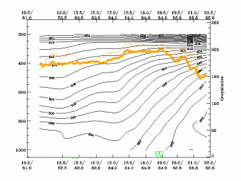
A different view of the development and maintenance of a Detached Warm Front cloudiness is given by the conveyor belt model. For the Detached Warm Front, a rising warm conveyor belt, as already described in detail in the Warm Front chapters, is also the dominant feature. It is the same relative stream which is involved in the band- and shield-formed Warm Front. The cloudiness of the Detached Warm Front appears where the relative streams turn from the northern culmination point to south, south-western directions. But there are two main differences between the classical and the detached types. While in the band and shield type the Warm Conveyor Belt is sinking in the area just described, it is rising in the area of the Detached Warm Front. The reason for this may be the strongly inclined frontal zone, indicated in the high gradient zone of the thickness, as well as in the isentropes of a vertical cross section (see Typical appearance in vertical cross section). In the classical types either no frontal zone (band type) or a weakening (shield type) appears in the area under consideration. A second difference can be found in the location and orientation of the Warm Conveyor Belt which seems to be more to the south of the synoptic scale ridge, which leads to the fact that the rising Warm Conveyor Belt overruns the frontal line in the area of the Detached Warm Front. However, more investigations will be necessary.
Due to the orography in central Europe, the cloud field of the Detached Warm Front is moving against the northern or the windward side of the Alps and therefore Stau effects are superimposed (see Stau Cloudiness ) causing increased weather events there (see Weather events).
|
|
|
|
|
|
|
|
|
|
|
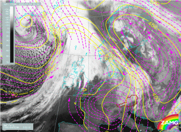
4 January 2005/00.00 UTC - Meteosat 8 IR 10.8 image; magenta: relative streams 296K - system velocity: 315°
10 m/s, yellow: isobars 296K.
|
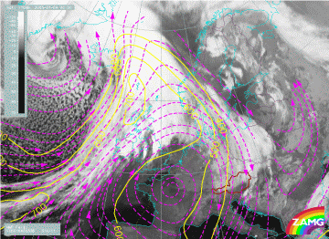
4 January 2005/00.00 UTC - Meteosat 8 IR10.8 image; magenta: relative streams 308K - system velocity: 314°
11 m/s, yellow: isobars 308K.
|
|
|
On the higher isentropic surface the Warm Conveyor Belt is rather similar. However, the rising in the area of the Detached Warm Front is rather less, from about 500 hPa over Eastern Germany up to about 350 hPa over Poland. The orientation of the relative stream lines fits much better with the orientation of the high cloud shield than on the lower isentropic surface.


