Wave - Weather Events

by ZAMG


Parameter Description
Precipitation
  • Increasing widespread precipitation.
  • Possibly thunderstorms in the area of the PVA.
  • The most intensive precipitation to be found within the area of emerging lower cloud spiral.
Temperature
  • Rising temperatures when the Wave passes over the observation point.
Wind (incl. gusts)
  • Increased surface winds in the Wave area. Intensive Wave can produce stormy winds.
Other relevant information  

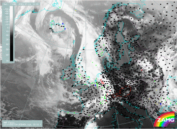
04 July 2005/12.00 UTC - Meteosat 8 IR 10.8 image; weather events (green: rain and showers, blue: drizzle, cyan: snow, purple: freezing rain, red: thunderstorm with precipitation, orange: hail, black: no actual precipitation or thunderstorm with precipitation)
The convective character of this Wave was already discussed in earlier chapters as well as during the description of the vertical cross sections. The image shows an extended area of precipitation (rain and in winter time snow) and thunderstorms within the area of the Wave.

Menu Of Wave
Typical Appearance In Vertical Cross Sections
References