Warm Conveyor Belt - Meteorological Physical Background
by ZAMG
- originates in a relative easterly to south-easterly flow within the lower levels of the troposphere in the ridge area ahead of the front;
- generally ascends pole ward (north to north-eastern direction) forming cloudiness due to the condensation of moist air;
- after turning to south-eastward directions ascending motion changes to descending motion, where cloud dissolution takes place.
As already mentioned Warm Conveyor Belts are directly involved in the frontal processes, but typical cloud configurations can also be observed separately from the frontal cloudiness. Different states of the atmosphere are responsible for these two types:
- The cloudiness of a front is developed within two relative streams: the Warm Conveyor Belt and a less wet relative stream from the trough area behind; the Warm Conveyor Belt is connected at least with the leading part of the cloudiness, therefore the relative stream lines approach or even overrun the surface front (or the TFP).
- In the case of separated Warm Conveyor Belt cloudiness the relative stream lines are in front of the frontal cloud band and the relative stream from behind crosses the frontal line in a forward direction, consequently approaching the stream lines of the Warm Conveyor Belt.
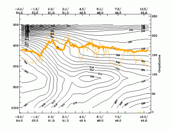
- These different situations show up in the vertical cross section of equivalent potential temperature in the case of a Warm Conveyor Belt being involved in the front. The upper troposphere in front of the Cold Front surface shows either an indistinct or a trough configuration of isentropes. In the case of a Warm Conveyor Belt being separated from the front, a second downward inclined crowding zone of isentropes can be observed in high and middle levels. The air in the Warm Conveyor Belt moves on these isentropic surfaces.
|
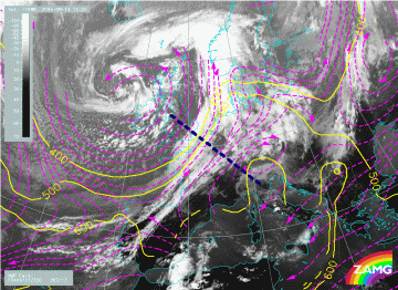
13 September 2004/12.00 UTC - Meteosat 8 IR 10.8 image; magenta: relative streams 320K - system velocity: 263°
13 m/s, yellow: isobars 308K, position of vertical cross section indicated
|
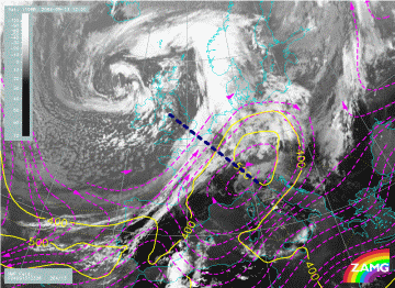
13 September 2004/12.00 UTC - Meteosat 8 IR 10.8 image; magenta: relative streams 326K - system velocity: 264°
13 m/s, yellow: isobars 326K, position of vertical cross section indicated
|
|
|
At the 326K surface the Warm Conveyor Belt, which has an ascending poleward direction, forms the cloudiness Warm Conveyor Belt. Above the Atlantic (at approximately 43N/10W) the conveyor belt splits into two branches. The southern branch turns from a north-eastward direction to a south-eastward one and forms the cloudiness which extends to the west coast of Portugal. The northern branch turns from a eastward to a north-eastward direction forming the cloudiness above the Gulf of Biscay and France towards Germany. The limiting stream line between the relative stream from behind the front and the Warm Conveyor Belt can be found above the convective cells. Therefore the cells are under the influence of the warm moist air mass of the Warm Conveyor Belt in lower layers, but in the colder drier air of the upper relative stream in higher layers. This is a typical situation for instability and convective development.
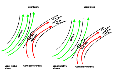
- At the rear boundary of the Warm Conveyor Belt close to the Cold Front cloud band, sometimes convective cells develop. This is the area where in lower levels the moist air of the Warm Conveyor Belt streams northward, while in higher levels the air in the drier relative stream from behind the front crosses over. This is a typical unstable layer of the troposphere leading, in combination with upward motion, to convective developments (compare the example before).


