Barrage Cloud - Cloud Structure In Satellite Images
by ZAMG
Appearance in METEOSAT Second Generation imagery
A belt or a bulge of relatively low but thick cloud forms along the windward side of a mountain barrier. Regularly there is an enhancement of preliminarily existing cloudiness in association with orography. In general, low grey cloudiness exhibiting a certain form and appearance can be seen as Barrage cloud along a mountain barrier.Sometimes Stratus and/or Fog Sheets which are slowly advected onto the mountain barrier have the same appearance as Barrage cloudiness, but they are usually associated with synoptic situations with a low pressure gradient and weak winds at all levels. However Barrage cloudiness is associated with a strong flow and forms after a frontal passage over mountains or redevelops within a baroclinic zone.
- IR imagery
- Mostly a dark grey to grey cloud bulge indicating low cloud with a relatively warm cloud top
- Light grey to white clouds form during cloud enhancement
- Light grey to white clouds form during cloud enhancement over the main mountain ridge
- The downwind edge of the mountain crest is sharply defined
- Because of the strong upper level stream also lee or high fibre clouds can often be formed to the lee of the mountain chain, appearing as bright grey to white (see Lee Cloudiness ).
- WV imagery
- Low level Barrage cloudiness is usually not seen in WV images, but the enhancement of frontal cloud during its passage over the mountain chain can be well seen in WV imagery
- Bright lee or high fibre cloudiness is also well seen in the WV image
- VIS imagery
- The sharp edge along the downwind side of the mountain barrier is best seen in the VIS image
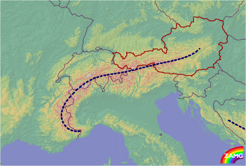
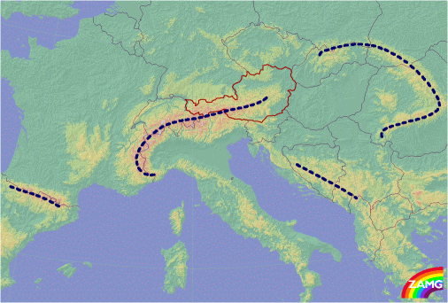
Barrage cloudiness in Europe is often observed over the Scandinavian Mountains, the Pyrenees, the Carpathian Mountains, the Dinarian Mountains and the Alps.
Alpine Barrage cloudiness
Alpine Barrage clouds take different forms depending upon:- The angle and direction of the flow against the main ridge of the mountain barrier, causing a characteristic appearance of the Barrage cloudiness bulge and extension towards the windward side.
- Whether it is a Barrage cloud within a frontal cloud band or separate Barrage cloudiness.
About 60 cases have been investigated in detail; 36 cases show frontal Barrage (8 cases Detached Warm Front) and 24 cases show separate Barrage cloudiness (13 cases with Barrage north of the Alps, 8 with Barrage south of the Alps and 4 cases with Barrage at the west Alps).
- Orthogonal (right angle) stream to the main Alpine ridge
- The orthogonal stream has a dominating northerly component throughout all levels
- Barrage cloudiness frequently forms after a frontal passage, when remaining cloudiness is enhanced along the windward side of the mountains.
The case of the 3 January 2005 shows Barrage cloudiness over Austria from an orthogonal stream. In the IR10.8 image the Barrage cloudiness can be observed as a separate feature after frontal passage (below left). The sharp edge towards the lee side of the mountains can be seen in the HRVIS image. The bright white cloud feature implies higher multilayered cloudiness (below right).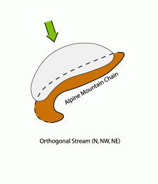 The IR10.8 image loop (above left) shows the passage of a front. It clearly shows the development of remaining cloudiness as Barrage on the north side of the Alps. To the south some lee waves are being formed just of the Alpine barrier. The behaviour of the Barrage cloudiness in the loop can be seen as a stationary cloud sheet directly above the windward slopes and main mountain ridge in Austria, extending upstream towards Germany and the Czech Republic.03 January 2005/12.00 UTC - Meteosat 8 IR10.8 image; SatRep overlay: names of conceptual models03 January 2005/12.00 UTC - Meteosat 8 HRVIS image; SatRep overlay: names of conceptual models
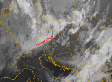
Special case of orthogonal stream:
- In this case the remains of a frontal cloud band are "tied" to the mountain chain, forming a characteristic elongated cloud band
- During the crossing of the mountain barrier the frontal cloud band ascends within its baroclinic zone
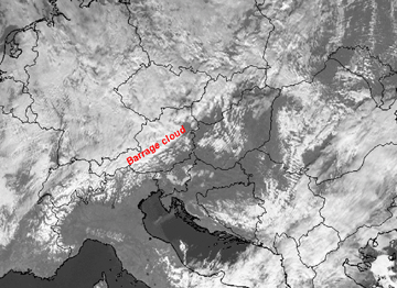
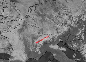
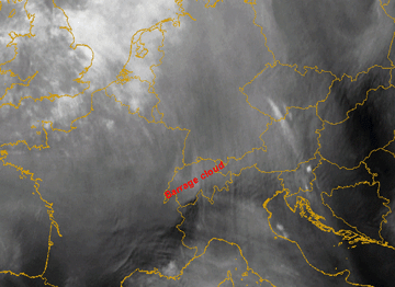
The IR10.8 image of the 12 January 2007 and the IR10.8 loop (below left) show a frontal cloud passage over Switzerland, orthogonal to the main Alpine chain. The remaining (and weakening) cloud intensifies again in the Barrage area (bright grey in the IR image). The Baroclinic Boundary of the system lies over France and Germany and consists of dark grey low clouds. In the high resolution visible image (below right) the sharp southern edge of the Barrage cloudiness can be observed. Also the enhancement during the Barrage process can be seen in the WV6.2 image (2nd row below left). Just south of the Alps the WV6.2 shows darker shades assuming the presence of some Foehn winds (see Foehn ). 12 January 2007/12.00 UTC - Meteosat 8 IR10.8 image; SatRep overlay: names of conceptual models12 January 2007/12.00 UTC - Meteosat 8 HRVIS image; SatRep overlay: names of conceptual models
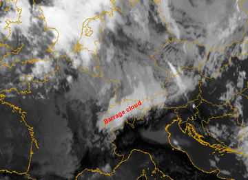
 12 January 2007/12.00 UTC - Meteosat 8 WV6.2 image; SatRep overlay: names of conceptual models
 - Southern orthogonal stream:
- The same mechanism takes place, only with the opposite direction of the flow, and with the Barrage cloud on the southern slopes
- Barrage over the southern Alps often causes heavy and persistent precipitation because of the high humidity content of the southerly flow arriving from the Mediterranean region is halted on the Alpine ridge. The resulting Barrage cloud to the south is part of the flow regime of a classical Foehn situation (see Foehn ).
The case of the 2 April 2007 is shown below. In an anticyclonic flow, remaining low cloudiness can be seen within the south western Alpine bow over northern Italy. A sharp edge to the cloud can be seen along the main Alpine crest in the IR10.8 image.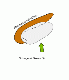 02 April 2007/12.00 UTC - Meteosat IR10.8 image; SatRep overlay: names of conceptual models
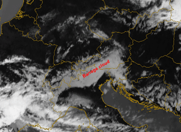
- Westerly stream
- A distinct cloud bulge forms along the western Alpine bow associated with a strong westerly flow towards the western boundary of the Alps.
- A secondary tangential thin branch of Barrage cloudiness forms along the main north and north eastern alpine ridge.
After the passage of a Cold Front, from Spain over E. France into Switzerland, Barrage cloudiness forms on the Western Alpine ridge. The Barrage cloudiness extends tangentially to the main Alpine ridge with a pronounced cloud bulge over the western Alpine bow.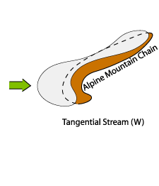
A distinct sharp edge on the lee side (below left) has formed which can also be well observed in the HRVIS image below right. The IR10.8 image loop below left shows the frontal passage and the development of the Barrage cloudiness which remains long after frontal passage. The most pronounced area of the Barrage cloudiness can be seen over the western Alpine bow, but the inner eastern Alps are also affected.08 March 2007/12.00 UTC - Meteosat 8 IR10.8 image; SatRep overlay: names of conceptual models08 March 2007/12.00 UTC - Meteosat 8 HRVIS image; SatRep overlay: names of conceptual models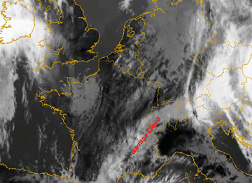
- Barrage Cloud appearing within frontal cloud bands
- The only indication of Barrage within the front is the enhancement of the frontal cloud band over the Alpine ridge as a result of forced ascent along the windward side. The sinking motion along the lee side results in cloud dissipation (see schematic below).
- Only embedded Lee cloudiness can be observed with this type.
In the IR image below left, the case of the 23 May 2006 at 06.00 UTC shows a pronounced area of cloud enhancement at the northern border of the western Alps and an area of descent at southern edge. The maximum cloud enhancement occurs over Switzerland and southern Germany.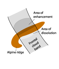 One common synoptic situation associated with the formation of long lasting Barrage cloudiness is the approach of a Detached Warm Front (see Detached Warm Front ). Here the downwind edge is not as sharply defined as usual. From experience, some cases of Barrage show a shift of the Barrage cloudiness somewhat to the lee side. This often seems to occur with Warm Fronts, with a marked southward displacement of high cloudiness.23 May 2006/06.00 UTC - Meteosat IR10.8 image; SatRep overlay: names of conceptual models
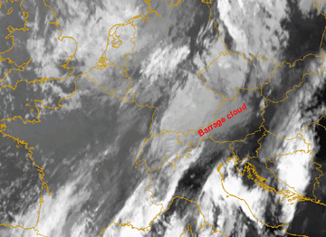
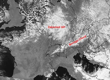
In the IR10.8 and HRVIS image from the 2nd November 2006 the enhancement in the area of Barrage associated with the frontal zone of a Detached Warm Front over Germany and Northern Austria can be seen. In the W. Alps Barrage cloudiness develops from the residual low cloudiness after the frontal passage (below left and right). In the IR10.8 image loop it can be seen that the descent along the lee side becomes more pronounced. A slight shift of the Barrage cloudiness somewhat to the lee side is also recognizable.
02 November 2006/12.00 UTC - Meteosat 8 IR10.8 image; SatRep overlay: names of conceptual models02 November 2006/12.00 UTC - Meteosat 8 HRVIS image; SatRep overlay: names of conceptual models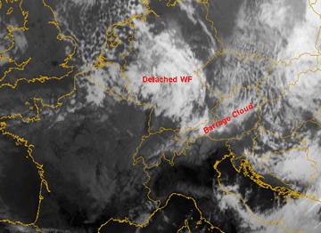
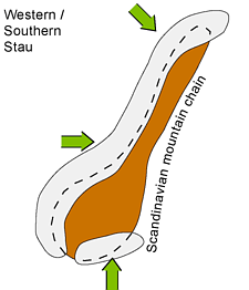
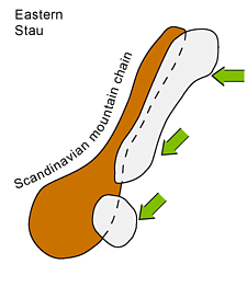
Scandinavian Barrage Clouds

|
|
|
|
|
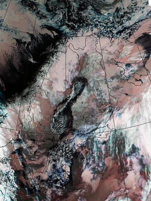
08 January 2002/01.28 UTC - NOAA image; Barrage Cloudiness pronounced on western coast of Norway
|
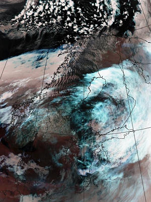
10 November 2002/19.00 UTC - NOAA image; Barrage Cloudiness is pronounced in Northern Sweden and Finland. Some Stau is seen even
in middle parts of Scandinavian mountains
|
Wind directions that are favourable in Scandinavia are S-W stream in southern Norway and the W-N stream over northern Scandinavia. Even NW-jets passing over the southern tip of Norway have caused Barrage Clouds. On the western side, the Barrage cases often appear together with Lee Clouds and Foehn on the eastern side of the mountains. Foehn is common even for the easterly cases. In southern Norway Barrage clouds sometimes grow larger covering a larger area than the coastal areas of south-western Norway.
In the easterly cases over the eastern side of the Scandinavian mountains, easterly low-level jets with wind speeds 30 knots or more are common. If the winds increase and back north, the Barrage Cloud usually stretches southwards along Sweden. Easterly cases may be quite dry and therefore only quite thin stratocumulus develops. With the easterly winds, there is often Foehn on the western Norwegian coast. Even in southern Norway northerly winds have caused Barrage Cloudiness that sometimes stretches down to the coastal region.
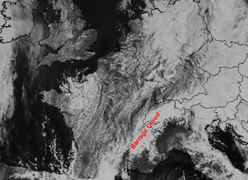
Barrage at other European mountain ridges
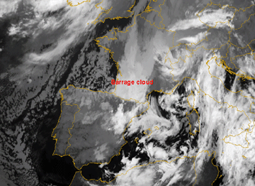
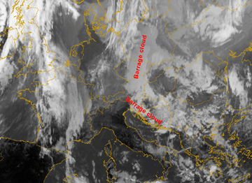
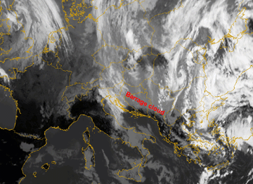
In the set of images below typical Barrage situations over the main central European mountain ridges can be seen (schematic below left). Below right (IR image) the Barrage case from 11 November 2004 along the Pyrenees is displayed. Low stratus is enhanced over central France towards the Barrage zone.2nd row below left shows Barrage cloud over the Carpathian and Dinarian mountains on 13 February 2006. Low stratus sheets are situated over the whole area, only slightly enhanced in the Barrage zone.
In the case of 14 March 2006 (2nd row below right), Barrage cloudiness over the Dinarian, mountains is clearly visible.
|
|
11 November 2004/06.00 UTC - Meteosat 8 IR10.8 image; SatRep overlay: names of conceptual models
|
|
|
|
|
|
13 February 2006/12.00 UTC - Meteosat 8 IR10.8 image; SatRep overlay: names of conceptual models
|
14 March 2006/12.00 UTC - Meteosat 8 IR10.8 image; SatRep overlay: names of conceptual models
|

