Barrage Cloud - Meteorological Physical Background
by ZAMG
Different types of Barrage events can be distinguished from the direction of the flow and whether there are separate Barrage Clouds or Barrage within frontal zones. Although the latter is usually accompanied by heavy precipitation (e.g. Cold Front or Detached Warm Front), in general, a dominating orthogonal component in the wind fields from 1000 hPa to 500 hPa generates more intensive precipitation. An acute angle between the stream and the mountain barrier still causes distinct cloudiness but inhibits intensive precipitation. Furthermore, more intensive precipitation is generated in frontal Barrage. From 32 cases with less shear, there are only 25 with strong precipitation, whereas out of 17 cases with vertical shear, 9 appear with strong precipitation.
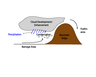
These two effects, Barrage and Foehn, are the reason for relatively cold air on the windward side and relatively warm air on the lee side of the mountains (at surface levels).
Convergence at low levels leads to a high pressure area within shallow cold air on the windward side, causing a characteristic ("nose like") horizontal pressure gradient across the mountain chain. This convergence is compensated by divergence above. A similar mechanism under opposite sign, leading to an area of low pressure, occurs on the lee side of the mountain chain.
Ascent of moist air is responsible for the enhancement or formation of Barrage cloudiness along the mountain slope. The appearance, form and the extension of such a cloud pattern depends on the flow crossing the mountain chain. The direction of the flow to the mountain chain, e.g. if it is orthogonal, tangential, causes different cloud formations (see Cloud structure in satellite images). As mentioned above, the change in wind direction and velocity with height will be responsible for the intensity of the Barrage event, either in the enhancement of the cloudiness or in the amount of precipitation. For example: if there is a northerly flow at low levels, and a strong westerly stream above, there will only be shallow cloudiness with weak precipitation on the windward side of the mountain chain.
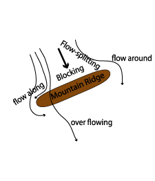
The physical processes behind Barrage cloudiness also show the concurrence between two main situations:
- A blocking situation with an increasing mid level flow (at the level of the mountain crest) around the ridge
- A non-blocking situation with a geostrophic flow over the ridge line (see schematic below)
The Chen - parameter is an indicator for the tendency of blocking and deflection (flow around):

where
| N | Stability |
| h | Height |
| U | Stream |
Values of the Chen - Parameter around 1 provide a non - blocking and complete over flow of air with a stable layer above the mountain ridge and geostrophic flow. Values >1 cause a blocking case with strong deflection of the flow at low levels. There is a split in the flow, with some flowing around the mountain chain.
Consequently the splitting/blocking has an effect on the intensity of the cloudiness and the precipitation of a Barrage event: The flow splitting causes a more diffluent stream at middle and lower levels, leading to a decrease of convergence and lifting on the windward side.
A second parameter that is also often referred to in literature in respect to Barrage cloudiness is the Froude number. The Froude number combines the influences of stability, wind speed and terrain height. The Froude number is dimensionless and indicates whether or not the flow has enough kinetic energy to rise over the barrier (Durran, 1990 and Houze, 1993. It therefore suggests whether or not the orographic lifting will occur directly over the terrain or upstream. High Froude number flow rises easily over a mountain barrier and robust upslope flow occurs, which can enhance precipitation over the windward side of a mountain barrier. When low Froude number flow is blocked by the terrain, lifting and enhancement of rainfall can occur upstream of the barrier (e.g. Grossman and Durran 1984).
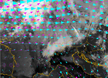
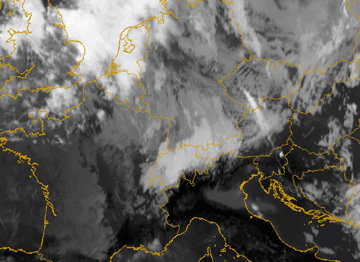
The example below shows the case of 12 January 2007. Driven by the westerly flow a narrow Barrage cloud forms along the western edge of the Alpine mountain ridge. In the wind field at 850 hPa (below left) a slight splitting of the flow around the mountain barrier of the Alps is seen. The half hourly IR10.8 image loop from 06.00 UTC to 15.00 UTC shows the growth of the Barrage cloud at the western Alpine ridge over eastern France. During the day the northern part of the flow is deformed and forced to propagate along the northern slopes of the Alps, also forming a narrow Barrage cloud. The cloud texture of the Barrage over southern Germany reflects the deformation and diffluence of the stream.
At the southern flank of the Alps marked cloud dissipation can be observed. The upper flow is indicated by the appearance of Lee Cloud fibres over northern Italy.
|
12 January 2007/12.00 UTC - Meteosat 8 IR10.8 image; magenta: wind vectors 1000 hPa, green: wind vectors 850 hPa
|
12 January 2007/12.00 UTC - Meteosat 8 IR10.8 image
|
|
|


