Sea-breeze - Meteorological Physical Background
by FMI and KNMI
The Sea-Breeze circulation is able to strengthen and/or changing (veering) the surface wind in large scale synoptic onshore circulations.
The existence and intensity of the Sea-Breeze depends strongly on seasonal and latitudinal factors and on the time of day. In tropical and subtropical coastal regions the Sea-Breeze is a regular phenomenon throughout the year bringing a pleasant cooling. At higher latitudes it is a common feature during spring and summer only, Clear skies, strong insolation and a temperature difference between land and sea at its maximum are relevant and important factors for the Sea-Breeze to develop.
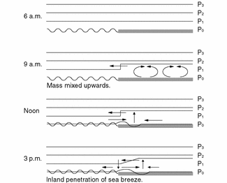
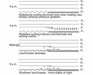
Daily life cycle
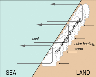
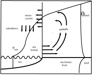
A simplified overview is provided using the following model. The left side of the scheme is a presentation of the developing onshore - wind in the Sea Breeze circulation. The scheme to the right is an example of the shallower Land Breeze circulation at night.
|
|
There are other explanations for the initiation of Sea-Breeze:
- Sea-Breeze is initiated at low levels, or
- Both Sea-Breeze and return current (representing the air flowing from land to sea above Sea-Breeze) develop practically at the same time.
- Sea-Breeze as a result of the difference in sensible heat flux over sea and over land.
The return current aloft carries the excess of air towards the sea. Cloud development frequently occurs in the ascending part of the circulation, while clouds tend to dissipate over the sea, where the air is sinking. When the air is very dry, as often is the case in spring and early summer, the cumulus clouds may not appear at all. In these cases the use of satellite imagery is clearly problematic for the detection of Sea-Breezes, while it may still be detectable using other remote sensing techniques, such as sensitive weather radars.
In the early afternoon, when the boundary layer heating over land is at its maximum, the highest activity of the Sea-Breeze circulation does occur with an inland track of generally tenths of kilometres - in some cases, even over a hundred kilometres. While moving inland the Sea-Breeze front tend to accelerate.
If the large-scale flow is weak, the direction of the Sea-Breeze often veers with time. This is a result of the Coriolis force having impact on the air flow. At higher geographical latitude and comparable strength of the forcing mechanism the component perpendicular to the coastline will be smaller or in other words the veering of the wind will be larger and the track inland will be smaller.
Generally the Sea-Breeze circulation have the largest horizontal dimensions in the Tropics.
Another factor influencing the wind direction along the coast is the regular existence of thermal lows over land in the afternoon.
A Sea-Breeze has a typical vertical dimension of 300 - 1000m, with the strongest wind speed at 50 to 200m above the surface. The return current is about twice as thick as the Sea-Breeze, leaving for the total vertical dimension of the Sea-Breeze circulation typically about 1 to 3 km. In the return current almost the same amount mass of air is returned to the sea, compared with the mass of air transported inland by the Sea-Breeze wind.
Later in the day, as solar radiation decreases, the Sea-Breeze dies out, the thermals weaken and the cumuliform clouds gradually disappear.
Factors influencing the Sea-Breeze development
Sufficient temperature contrast between the land and sea surfaces is needed for the initiation of the Sea-Breeze. In this respect the physical background differs for Coastal Convergence (see Coastal Convergence ) in which the differential friction over land and over the sea is the main component for the development.The coastline shape can either enhance or inhibit Sea-Breeze development. For example, merging of two Sea-Breezes originating from both sides of a peninsula enhances convection. On the other hand, over land areas adjoining bays the Sea-Breezes tend to diverge, which enhances low-level descent of air.
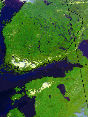
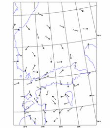
The image below shows a case over Finland, in which Sea-Breezes (barely visible as a line of cumulus) merge along the Finnish west and south coasts, producing some intensive, local Cb Clouds in the south-western corner of Finland. Meanwhile, along the coast adjacent to the eastern Gulf of Finland the wind field is more divergent and no clouds are produced.
|
02 August 1999/13.29 UTC - NOAA RGB image (channel 1,2 and 4)
|
02 August 1999/15.00 UTC - synoptic wind observations
|
|
|
- If the large-scale flow is weak, the Sea-Breeze circulation dominates.
- If opposing (offshore) large-scale wind exists, it can either inhibit the Sea-Breeze totally or slow down the development of the Sea-Breeze. Under these circumstances the Sea-Breeze may develop late in the afternoon moving inland very slowly.
- The most intensive Sea-Breeze fronts develop in association with an opposing light large-scale flow. Strong low-level convergence within the Sea-Breeze front may result in strong convection restricted to a narrow line along the front.
- If moderate or strong large-scale onshore winds exist, the Sea-Breeze circulation often has no possibilities to develop, as the large-scale flow advects the cool sea air over land, reducing the temperature and pressure gradients.
- Weaker onshore winds however can change into a developing Sea-Breeze front. An example is presented in the chapters cloud structure, weather events and cross sections.
Additionally, capping temperature inversion above the boundary layer tends to intensify the Sea-Breeze circulation.
Sea-Breeze study with a mesoscale model by using sensible maximum heat flux
The "Upwards Theory", based on temperature differences over sea and land, is not always the best tool to be used in Sea-Breeze forecasting, it has a few disadvantages. Often the pressure is not falling in a small area near the coast but over a much larger area inland. Consider two boundary layers, 1000m and 2000m thick, with no difference in initial θl (over land) and θS (over sea). If, by the end of the day, no temperature differences exist between the two heated layers the total amount of used energy to warm the thickest layer is twice as much compared to the thinner layer. Double the heat, double the pressure gradient (to be calculated with the law on hydrostatics) with in the end a stronger Sea Breeze in the thickest layer.For understanding the physical and dynamic processes, explaining the Sea-Breeze circulation, a study was done with a numerical model in a boundary layer of 2000m. At the start the atmosphere is at rest and strong solar insolation is heating the air over land over a much larger surface then the coastal regions, making the air to expand not only vertically but also horizontal towards the sea.
The total amount of heating on a specific day can be calculated by a mesoscale model. It is the total amount of energy since day break up to the time at the maximum strength of the Sea-Breeze. This is called the maximum sensible heat flux with values ranging from 100 to 400 W/m2, 200 W/m2 is often used (graphs in Key-Parameter and Weather - Events).
The vertical velocities at the leading edge of the heated air over land are stronger in relation to the coastline due to the existing horizontal velocities towards the sea, the offshore low level wind component. At low levels, a 100 metres, the so developed convergence over sea initiates little pressure increase over sea and a quit rapidly turning of the wind and the onset of the See-Breeze. These new developed onshore wind of the Sea-Breeze initiate divergence over sea and convergence over land. Pressure levels lift slowly over land due to the mass convergence and the onset of a return flow (offshore) above the flow of the Sea-Breeze. This explains why the originally weak flow at a height of about 1000m, following the veering of the low level flow, soon to back again into an offshore wind.
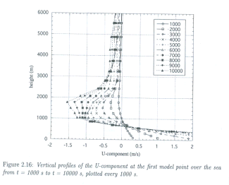
The image below is a scheme of the vertical extent of the U-component of the See-Breeze from this study. Below 500m an increasing (in time after the onset) westerly wind component exist. At the same time a return flow sets in just above the Sea-Breeze with equal strength, reaching a maximum around 1500m. This vertical profile is calculated for a grid point over the sea close by the coast, the starting point of the Sea-Breeze.
A Sea-Breeze circulation starts with an opposite wind, an offshore wind, soon changing into an onshore wind at low level, followed by a return flow (offshore) above within about half an hour.