Open Cell Convection And Closed Cell Convection - Cloud Structure In Satellite Images
by KNMI
Appearance in Meteosat Second Generation imagery
IR10.8 µm imagery:
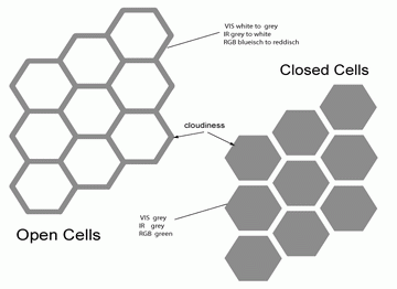
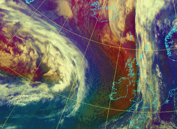
In Meteosat-8 IR imagery the pattern of Open Cells is also easily discernible, due to the temperature difference between the cloud tops at the borders and the surface in the cloud free centres. Closed Cells are not so easily discernible in IR imagery. This is due to the extensive cloud cover, which has a small temperature contrast at the cloud tops. Due to this small temperature contrast a region of Closed Cells looks rather 'smooth' in IR imagery, and the hexagonal cellular structure is not visible unless the cells start to break up and the cloud free zones between them grow wider. Closed Cells have the 'smooth' appearance in IR imagery in common with other low clouds, e.g. Stratus/Fog and Stratocumulus sheets.HRVis, Vis0.6 and Vis0.8 µm imagery:
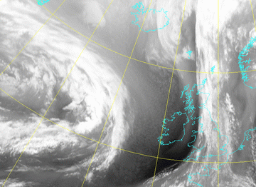
The hexagonal patterns of Open and Closed Cellular Convection can easily be seen in Meteosat-8 VIS imagery. In Meteosat-8 Hires VIS images the cellular structure is even better visible due to the higher resolution.WV6.2 and 7.3 µm imagery:
In the 6.2 WV channels the OCC/CCC are normally invisible, due to the limited vertical extent (usually only up to 1 - 5 km), while the 7.3 WV channel will give some structure. WV imagery however, can indirectly be useful: the horizontal advection of upper-level moist air (although without associated clouds) over the CCC Sheets may change the radiation balance of clouds, further leading to dissolving of the cloud sheet.|
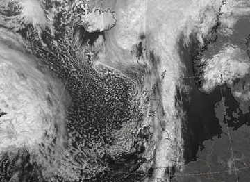
23 September 2005/12.00 UTC - Meteosat 8 HRVIS image
|
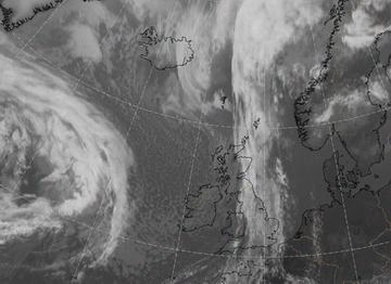
23 September 2005/12.00 UTC - Meteosat 8 IR 10.8 image
|
|
|
|
|
|
23 September 2005/12.00 UTC - Meteosat 8 WV6.2 image
|
23 September 2005/12.00 UTC - Meteosat 8 VW 7.3 image
|
RGB imagery
Airmass imagery:
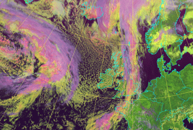
The Airmass-RGB is an artificial composite consisting of the WV 6.2 - WV 7.3 brightness temperature difference (BTD), on red, the IR 9.7 - IR 10.8 BTD on green and the WV 6.2 channel on blue. Typical features seen on the Airmass RGBs include dry intrusions, deformation zones and jet streaks. In the area of open cells we can often see the more deep blue colours, (polair air), and sometimes also the reddish colour, (cold advection and stratospheric intrusion). In the area of closed cells the colour will become more greenish due to the warmer subtropical air."Daytime Microphysical" (RGB-day-ice-water-snow)
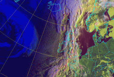
The "nighttime microphysical" imagery RGB consist of VIS 0.6, NIR 1.6 and IR 10.8 µm channels. The low level clouds are seen in these images as light yellowish/greenish. High clouds are reddish with some yellow spots due to noise in the 3.9 channel. This combination greatly helps in discriminating between ice, water and snow.Closed cells are seen as yellowish or yellowish-white clouds and cloud tops of the open cells with ice particles will appear as pinkish.
|
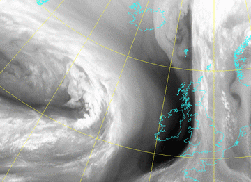
23 September 2005/12.00 UTC - Meteosat 8 airmass RGB image
|
23 September 2005/12.00 UTC - RGB day-ice-water-snow image
|
|
|
|
|
|
23 September 2005/07.00 UTC - RGB day-ice-water-snow image
|

