Open Cell Convection And Closed Cell Convection - Meteorological Physical Background
by KNMI
Satellite images frequently show large areas of mesoscale cellular convection. These areas are predominantly observed over water surfaces. This mesoscale cellular convection is characterized by honeycomb-like patterns of shallow (generally 1-2 km but in some occasions larger) convective cloudiness, arranged in either 'open' or 'closed' cells. The former have cloudy borders and cloud free centers whereas the latter have cloud free borders and cloudy centers. Open and closed cells are part of a distinct lifecycle in Cold Air Outbreaks from continents or ice-surfaces over warmer sea surfaces. In this lifecycle cloudiness develops from Stratus/Sea-Fog via Cloud Streets into Open and Closed Cells.
Open and Closed Cells mostly occur over water surfaces, but Open Cells can also develop over land, when cold air is advected over a land surface heated by solar insolation. A favorable period for this is springtime. Open and Closed Cells can also be advected from sea onto land by the mean flow. Over land the cellular patterns are somewhat disturbed due to the increased surface friction over land.
Rayleigh-Bénard cells:
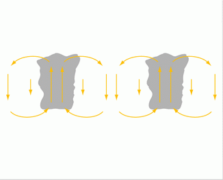
The organisation of clouds into a hexagonal pattern can be regarded as an atmospheric manifestation of Rayleigh-Bénard cells. These cells are formed when convection occurs in a fluid which is confined between an upper and a lower boundary and is heated from below. The heating from below causes convection in the fluid, and rising motions (in the manifestation of 'updraft plumes') will occur. When the rising fluid meets the upper boundary it has to spread sideways. If this happens at an uniform speed, the boundary of the flow will have the shape of a circle. When there are more spots with rising fluids, the boundaries will grow towards each other and where 2 boundaries meet the converging fluid is forced to flow downwards. At the bottom of the layer the fluid has to flow sideways again and in this way the circulation is closed. The hexagonal pattern as observed from above, is caused by the convergence of the sideward motions originating from many 'updraft plumes'. When the updraft plumes are of uniform strength a regular hexagonal pattern will be visible.
In the case of Open and Closed Cellular Convection, the lower boundary is the sea or land surface and the upper boundary is an inversion (often a subsidence inversion). However, in the case of the theoretical Rayleigh-Bénard cells the only forcing factor is the temperature difference, in the atmosphere there are a number of extra factors and processes which influence the convective circulation. These factors and processes interfere with each other and resulting effects can be enhanced or dampened.
1) One of these factors and processes is the large scale vertical motion in the boundary layer imposed by synoptic scale systems. When cellular convection occurs, the large scale vertical flow has a marked influence on the orientation of the circulation in the cells. Open cells will develop if the large-scale vertical motions in the fluid layer are downwards, closed cells will develop when the large-scale vertical motions are upwards. However the large-scale vertical motions are not strong enough to overcome the inversion at the top of the layer.
2) Another important factor in the atmosphere is the release of latent heat due to condensation. Initially the convection is only thermally induced, but when condensation occurs latent heat release adds to the thermal forcing. In the development of a cold air outbreak condensation becomes quickly a factor of importance when clouds develop such as sea-fog, stratus or convective clouds.
3) Closed Cells have a larger cloud deck and therefore cloud radiative processes and entrainment are also factors which influence the direction of the circulation in the cells.
Synoptic Environment and Characteristics
In the following paragraphs the typical synoptic environment and other characteristics will be discussed.Open Cellular Convection:
Open Cellular Convection is mostly seen in cold air outbreaks, when cold and dry air from continents is transported over a relatively warm (water) surface. This flow often occurs behind a Cold Front (see
Cold Front
). The air mass is modified by the input of heat and moisture from the water surface. Near the water surface a mixed layer will be formed, which is capped by an inversion. This inversion stems from the period that the air resided in its source area. The depth of the mixed layer will increase with increasing distance from shore due to the continuing input of heat and moisture from the water surface. Clouds develop during the transformation of the air mass. At first Sea-fog or Stratus clouds will occur. Further downstream they will develop into Cloud Streets (see
Cloud Streets
) and eventually cellular convection will occur (Open and Closed Cells). The appearance of cellular convection can be considered as the mature stage of the air mass transformation. In this stage the mixed layer has reached its final depth and is not deepening anymore with increasing distance from the original source area.
Cellular convection is confined to a shallow layer, and dynamical forcing is not a factor. However, when dynamical forcing (e.g. PVA near upper-troughs) occurs in a cold air outbreak, the convection will be enhanced and EC (see
Enhanced Cumulus
) and Comma (see
Comma
) will form.
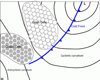
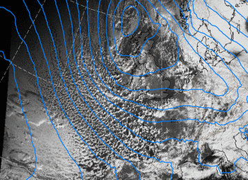
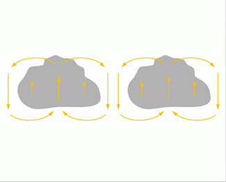
Open cells tend to develop in a cyclonic flow at the rear side of a mature cyclone, while closed cells preferably exist in an anti cyclonic flow with subsidence in the lower troposphere (see scheme below).
Whether Open or Closed cells form chiefly depends on the intensity of cold air, and the boundary between areas of Open and Closed cells is said to coincide with the strong wind axis of the upper level (Images in Weather Forecasting M. J. Bader )
|
11 March 2006/12.00 UTC - Meteosat 8 IR image; blue: isobars
|
|
|
|
|
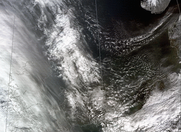
11 March 2006/12.00 UTC - Meteosat 8 HRVIS image
|
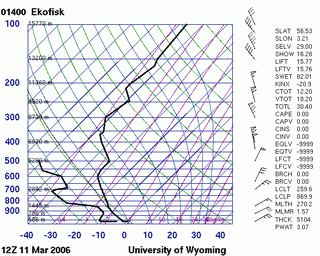
11 March 2006/12.00 UTC - Tephigram Ekofisk
|
|
|
| Height (hPa) | Winddirection (Deg) | Windspeed (kt) |
|---|---|---|
| 1007 | 010 | 17 |
| 1000 | 015 | 17 |
| 925 | 020 | 23 |
| 850 | 350 | 25 |
| 772 | 295 | 23 |
| 700 | 295 | 23 |
Closed Cellular Convection:
Closed Cellular Convection can occur in two different situations: in the aforementioned cold air outbreaks and in a subtropical anticyclone. The first case is a somewhat mature or final stage in the developments in a cold air outbreak. The closed cells are often situated a very far downstream and immediately in the rear of a Cold Front (see Cold Front ) or near the anticyclone which flanks the cold air outbreak to the west. The second case is a typical marine stratocumulus situation, within a subtropical anticyclone and often also situated over relatively cool ocean currents. In both situations there is a well mixed and moist shallow boundary layer situated underneath quite a strong subsidence inversion. The subsidence inversion functions as a strong cap for convection by hindering the vertical growth of the clouds and forcing them to spread out horizontally
|
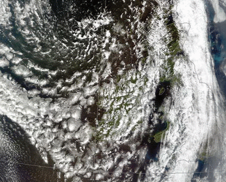
18 July 2005/12.00 UTC - Meteosat 8 HRVIS image
|
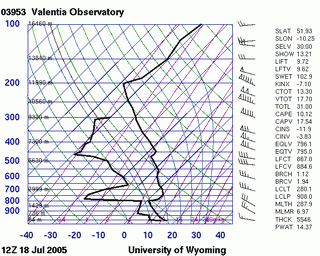
18 July 2005/12.00 UTC - Tephigram Valentia
|
|
|
| Height (hPa) | Winddirection (Deg) | Windspeed (kt) |
|---|---|---|
| 1028 | 060 | 12 |
| 1000 | 065 | 25 |
| 925 | 080 | 25 |
| 850 | 075 | 35 |
| 700 | 065 | 45 |


