Front Intensification By Jet Crossing - Meteorological Physical Background
by ZAMG
- the frontal circulation (for instance an Ana Cold Front) causes lifting processes within the front;
- the cross circulation in the left exit region of a jet streak causes an intensification of the temperature gradient (frontogenesis);
- a PVA maximum in the left exit region contributes to upward motion.
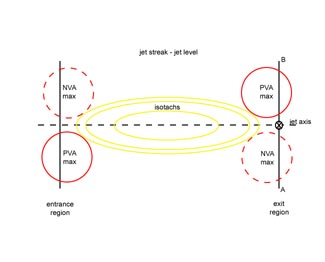
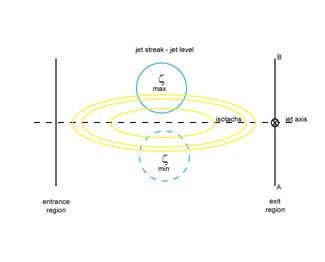
The typical distribution of convergence and divergence, which is caused by the vertical circulation in the area of the exit and entrance region of a jet streak, can be explained as follows: As a consequence of the increased wind shear in the centre of the jet streak a maximum of cyclonic relative vorticity can be found on the cyclonic side and a maximum of anticyclonic relative vorticity on the anticyclonic side of the jet axis. As the jet streak propagates downstream, a maximum of positive vorticity advection exists in the left and a maximum of negative vorticity advection in the right exit region. In the area of the entrance region the situation is reversed. On the other hand, as a consequence of the acceleration of the air parcels in the entrance and deceleration in the exit region, ageostrophic wind components can be found. These wind components point, at the jet level, from the anticyclonic to the cyclonic side in the entrance region and from the cyclonic to the anticyclonic side in the exit region. As a consequence of vorticity advection and ageostrophic winds, convergence can be found in the right exit and left entrance, divergence in the left exit and right entrance region at upper levels of the troposhere (at approximately 300 hPa - jet level).
Often it also can be observed that enhanced cloudiness develops within the left exit region of a jet streak in the cold air mass in the upper level trough behind a Cold Front. This kind of cloudiness can be seen in the satellite image either as cellular clusters (see Enhanced Cumulus ) or as a comma-formed cloud band (see Comma ).
The model of the frontal intensification by a jet streak, shown in the figures below, is an idealized model, which describes a straight or only very slightly curved jet streak. But in reality the curvature of the jet is usually stronger. Therefore positive vorticity advection can be found on the cyclonic as well as on the anticyclonic side of the jet axis. But as a consequence of the additional cyclonic shear, the main PVA maximum remains on the cyclonic side close to the jet axis.
|
|


