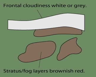
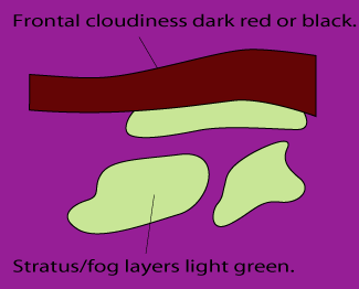
Fog And Stratus - Cloud Structure In Satellite Images
by FMI
Specific pattern features related to different St/fog types:
- The edges of radiation St/fog over land sharp but irregular, frequently bounded by terrain features.
- Over the oceans the edges are smoother.
- Valley fog is very easy to distinguish, since its dendritic edges follow the height contours of the valleys.
- Advection St/fog has a more regular edge pattern than radiation fog, which is restricted by the terrain features.
Appearance in METEOSAT 8 imagery
IR 10.8 imagery:- The grey shades of cloud sheets usually grey or dark grey indicating relatively low (warm) cloud tops.
- The detection of cloud sheets using the IR image sometimes proves to be difficult, when the temperature difference between cloud tops and land surface small.
- The temperature difference can be reversed, that is, St/fog top can show warmer temperature than surrounding cloud-free land surface areas causing a black St/fog. This is especially the case in high latitudes during the winter when, in situations of intensive low-level temperature inversion, Fog tops can be much warmer than adjacent land areas. This is often called as "Black Fog".
- Animated loops greatly help in detecting low clouds and their movement.
WV 6.2 imagery:
- WV images cannot be used directly for the detection of St/fog, as low-level cloudiness does not contribute to the WV image.
- However, WV images can sometimes be used indirectly in combination with VIS images; the advection of moist air (even without any cloudiness in IR or VIS images) above a St/fog-topped boundary layer can assist in the dispersion of low-level clouds.
VIS imagery:
- The grey shades of St/fog usually white or grey depending on the thickness of the cloud sheet and the elevation of the Sun.
- The overall flat appearance characteristic for St/fog in VIS 0.6 or 0.8 images, but in HRVIS images the top of Stratus can show more detailed patterns.
- VIS images show stratus clouds much better in daytime because of their strong reflectance.
|
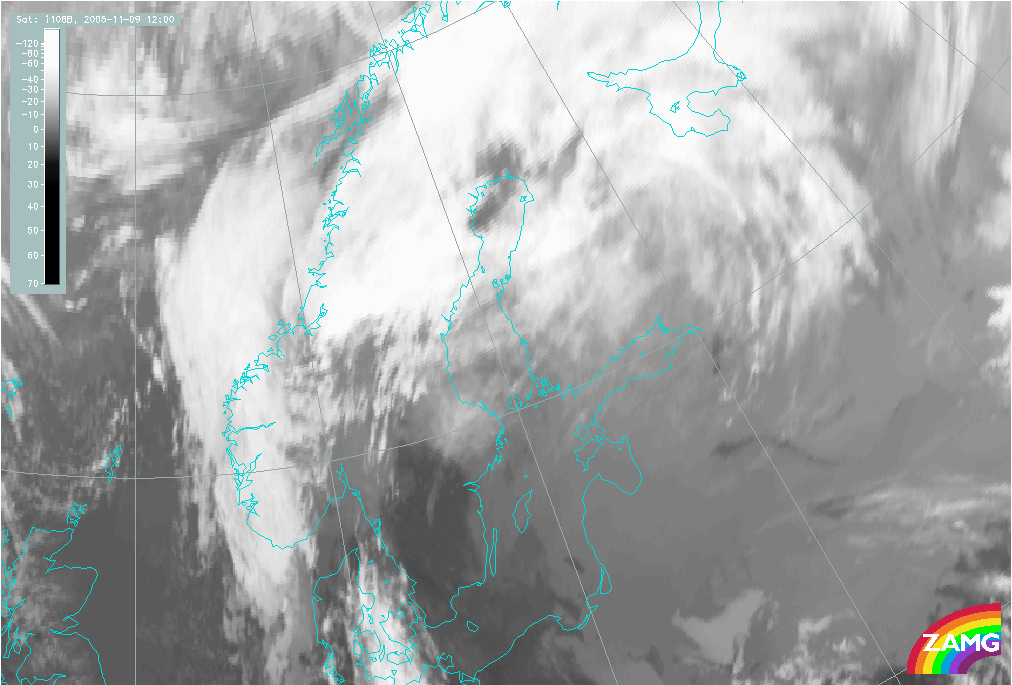
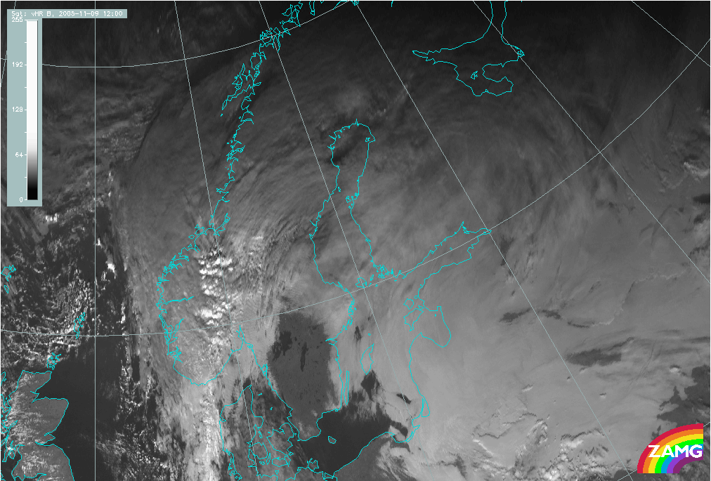
09 November 2005/12.00 UTC - Meteosat 8 IR 10.8 image
|
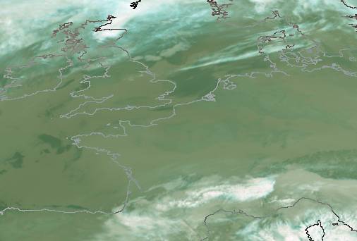
09 November 2005/12.00 UTC - Meteosat 8 HRVIS image
|
|
|
|
|
|
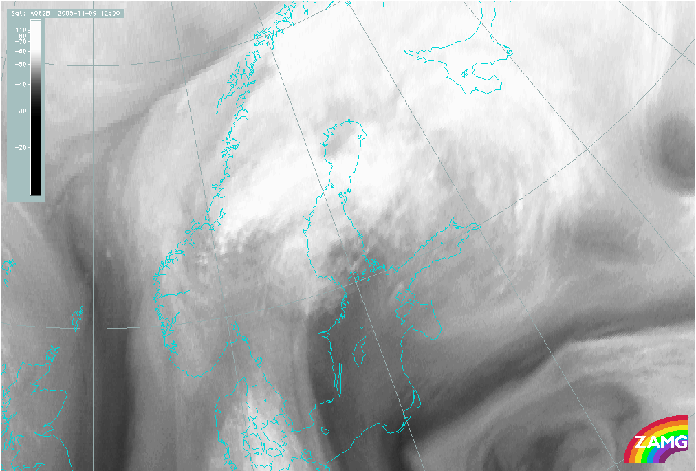
09 November 2005/12.00 UTC - Meteosat 8 WV 6.2 image
|
By contrast, in the VIS image the St/Fog layer is clearly distinguishable as light grey, well-defined cloud sheets. Even in the VIS image the cloud top is rather flat and featureless, but the edges of the cloud sheet are clearly distinguishable in places where there are no overlying upper level clouds.
The Water vapour image shows only the water vapour content in the upper and middle troposphere and does not directly help the detection of St/Fog.
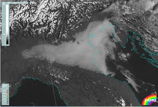
An example from southern Europe is shown below. A radiation fog area is located over Po Valley in Northern Italy. The loop of HRVIS images shows the fog layer being almost stationary throughout the day. The outer edges in the north and south are restricted by the slopes of higher terrain, while over the sea the cloud layer is slowly advected by the wind.
MSG RGB composite images
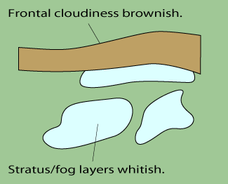
RGB combination images greatly help in identifying low level St/Fog. The great advantage of these combination channels is that the low-level cloud layers can be seen even when middle or upper level clouds may be present.The most used combinations for identifying low-level clouds:
- "Day Natural colours" NIR1.6;VIS0.8;VIS0.6 (daytime): St/Fog whitish-pinkish
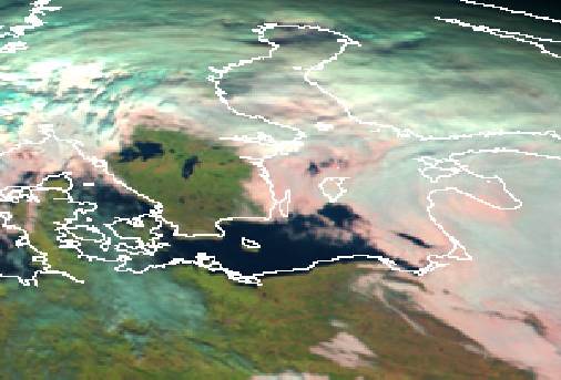
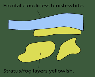
- "AVHRR inherited" VIS0.6;VIS0.8;IR10.8 (daytime): St/Fog yellowish
- "Day Microphysical" VIS0.8;IR3.9;IR10.8 (daytime): St/Fog whitish-light bluish
- "Day Solar" VIS0.8;NIR1.6;IR3.9 (daytime): St/Fog whitish
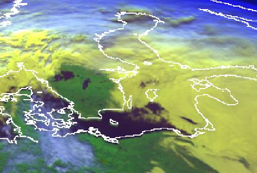
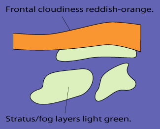
- "Night Microphysical" (IR12.0-IR10.8);(IR10.8-IR3.9);IR10.8 (night-time): St/Fog light greenish
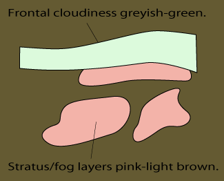
- "AVHRR inherited" IR3.9;IR10.8;IR12.0 Night-time and daytime) : St/Fog pinkish (night-time) or greyish-green (daytime)
As can be seen, many of the combinations exploit the NIR 1.6 and IR 3.9 wavelengths. These wavelengths are very useful for low-cloud detection since they effectively can differentiate low water (Stratus) clouds from ice clouds or snow.
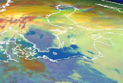
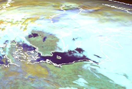
The MSG RGB daytime combination images below show a case of radiation and advection fog and Stratus over Finland, the Baltic Sea and the Baltic States. Different RGB combinations show St/Fog in different colours, but in all combinations the low cloud layers are well distinguishable from the ground or from the thicker frontal clouds. Especially useful these combinations become when the ground is snow- or ice-covered: all combinations exploiting 1.6 µm and 3.9 µm wavelength discriminate the low clouds from snow clearly.
|
09 November 2005/12.00 UTC - Meteosat 8 RGB image (NIR1.6, VIS0.8 and VIS0.6)
|
|
|
|
|
09 November 2005/12.00 UTC - Meteosat 8 RGB image (VIS0.6, VIS0.8 and IR10.8)
|
|
|
|
|
09 November 2005/12.00 UTC - Meteosat 8 RGB image (VIS0.8, IR3.9 and IR10.8)
|
|
|
|
|
09 November 2005/12.00 UTC - Meteosat 8 RGB image (VIS0.8, NIR1.6 and IR3.9; winter settings)
|
|
|
|
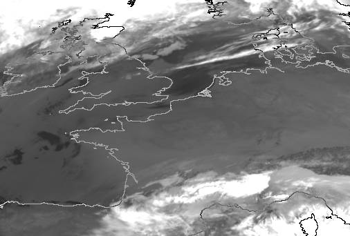
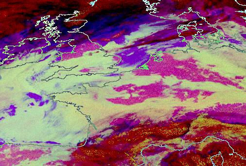
The example below illustrates a night-time situation over Central Europe. Radiation fog extends throughout the continent, but with large gaps in the cloud sheet. Detecting these gaps (for example over western parts of Germany and eastern parts of France) is very difficult with the IR 10.8 image alone.
|
09 November 2005/12.00 UTC - Meteosat 8 RGB image (IR3.9, IR10.8 and IR12.0)
|
|
|
|
|
09 November 2005/12.00 UTC - Meteosat 8 RGB image (IR12.0-IR10.8, IR10.8-IR3.9 and IR10.8)
|
|
|
|
Discriminating Stratus from Fog
Stratus and Fog are phenomena that are easy to differentiate for a human observer at ground level. The definition of each has been formulated as follows:Stratus is used to describe flat, featureless clouds of low altitude, typically less than 300 metres. On the other hand, fog is a stratus cloud in contact with the ground. Horizontal visibility in fog is less than 1 km.
The reason why these two phenomena are discussed together is the fact that for satellite sensors viewing them from above the differentiation is not at all simple. The only real difference between Fog and Stratus is the different altitude of the cloud base, which for Stratus lies a few hundred meters above ground, whereas in Fog the cloud base descends to ground level.
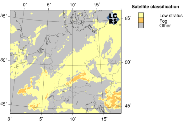
However, in quantitative satellite image interpretation requiring calculation of several cloud properties (such as cloud water distribution and cloud optical thickness), a discrimination between low stratus and fog areas is possible at daytime. Given that fog is a cloud in touch with the ground, a comparison of cloud base height with surface elevation can be used to discern fog presence. Cloud base height is computed as a difference between cloud top height and cloud thickness. The former is retrieved by interpolation of cloud margin heights (from relief or temperature lapse). The latter is determined by fitting a model of vertical cloud water distribution to the satellite-retrieved liquid water path.
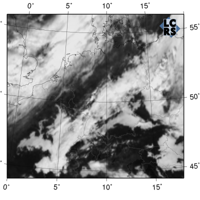
This approach can be illustrated with the following example. A traditional MSG visible channel image shows an area of low cloud over Central Europe. After the inclusion of quantitative satellite image interpretation algorithms the computed fog areas can be discriminated from stratus areas.