Fog And Stratus - Meteorological Physical Background
by FMI
The reason why these two phenomena are discussed together is the fact that for satellite sensors viewing them from above the differentiation is not at all simple. The only real difference between Fog and Stratus is the different altitude of the cloud base, which for Stratus lies a few hundred meters above ground, whereas in Fog the cloud base descends to ground level. A recent solution for automatic diagnosis of whether the cloud is at the ground (fog) or lifted off the ground (stratus) was presented in previous chapter (see Cloud Structure In Satellite Images ).
This chapter mainly focuses on advection Stratus/fog and Radiation Fog.
Favoured synoptic environment for St/Fog
Fog (or low Stratus) is formed, when moist air near ground level starts to condensate. This condensation can be produced in the atmosphere by three mechanisms:- By ascent and resultant cooling of an air parcel.
- By radiative heat loss.
- By the mixing of two parcels of slightly unsaturated air initially having different temperatures.
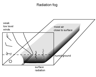
Radiation Fog formation typically calls for clear skies, ample moisture in the surface layer and light winds. Preferred locations to fulfil these conditions can be found adjacent to high pressures over land (mostly during the winter season) with associated weak pressure gradient. Wetness of soil significantly increases the chances of Radiation Fog, for which reason a very favoured situation for Fog formation is the sky clearing and wind decreasing in the evening after a rainy day. Too strong wind will most likely create Stratocumulus than Stratus.
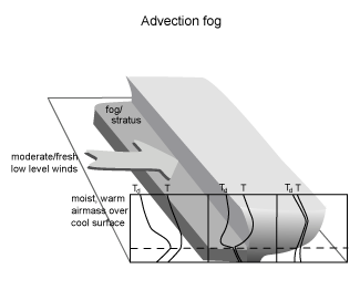
For the Advection Fog the important factors are the advection of moisture and temperature by the wind. Depending on the wind speed and fetch over water the interaction between the cooler surface layer and the overlying air results in low-level Stratus cloudiness and even Fog. As an average moderate (4-7 m/s) surface winds are typical for Advection Fog occurrences. Moist and warm southwesterly or southerly air streams over cool waters such as over cold ocean currents can create very extensive Fog sheets. Advection Fog is also frequently observed in wintertime low pressure warm sector areas over the continents.
Radiation Fog
As the Fog gets thicker, it becomes more uniform in the vertical, with a well-defined top. Depending on the season and synoptic conditions the Radiation Fog may or may not develop into a mature Fog. For example in summer, Fog layers are most often thin due to short nights. In the winter, however, under stationary synoptic situations Radiation Fog or lifted Fog (Stratus) can last for days.
The dissipation of Radiation Fog can take place through the following mechanisms:
- The spreading of a cloud sheet over the Fog, which reduces the radiative cooling at the Fog top layer.
- Atmospheric layers with high amounts of water vapour can help to dissipate fog by long wave radiation.
- Heat from the ground can lift the Fog into low cloud.
- Increasing shear at Fog top caused by increasing wind above the Fog increases the entrainment of dry air into the cloud and accelerates the rate of dissipation.
- In mature Fog the settling of droplets to the ground or onto vegetation contributes significantly to the dissipation.
- Solar radiation (excluding mid-winter) can penetrate to the ground in places where Fog is thinner (such as elevated places) and heat the ground and evaporate the Fog. Consequently, heat will be convected into the cloud. During summertime due to short nights the Fog has no time to thicken long enough, before the morning sun already starts heating the ground and breaks the Fogs into patches and later maybe into fair-weather cumulus.
Advection Fog/St
Important factors for the formation of Advection Fog are the fetch over the sea (or over land with wet snow) and wind speed. A long fetch together with not too high a wind speed allows the cloud to sink lower and eventually form Fog. Over land areas the snow temperature is an important factor: snow having below-zero temperatures can easily absorb moisture from overlying air. This is due to the smaller water vapour pressure for ice surfaces compared to liquid water surfaces. Fog formation over dry snow is; therefore, much more common than over wet snow, as wet snow is a source of moisture.
Advection Fog can be expected to be persistent, since the synoptic situation does not change rapidly. In wintertime warm sectors the middle and upper troposphere normally remain relatively dry, which favours extensive low level cloud decks to persist. Either a frontal passage and change of air-mass, increasing wind/turbulence or the advection of mid-level or low-level cloud over the St/fog top are needed for dissipation of the Fog to take place. The advection of sea Fog over warmer water can also lead to lifted stratus and possibly dispersal of cloud.
Advection Fog has the same tendency to shrink from the outer edges as Radiation Fog, but the advection of the clouds has to be taken into account. Brighter spots indicating thicker and more persistent cloud may be carried downwind, while the upwind edges of clouds will clear more rapidly.


