Cloud Streets - Meteorological Physical Background
by KNMI
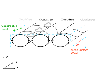
Inflection instability is caused by an inflection point in the wind velocity component perpendicular to the roll system. This inflection point is caused by a combination of the Ekman-layer shear-flow and cold advection. As a result of friction, the winds in the lowest levels will veer with height. The friction-effect decreases with increasing height and therefore the wind will tend to back again because of the cold advection which is present. As a consequence of this turning wind vector, in the lowest layers, a roll system develops.
Synoptic Environment and Characteristics
In the following paragraphs the typical synoptic environment and other characterisitics will be discussed.
Cloud Streets over sea:
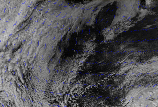
In many cases Cloud Streets can be seen during synoptic scale outbreaks of cold, dry air from continents over a neighbouring relatively warm ocean. This flow often occurs behind a Cold front (see
Cold Front
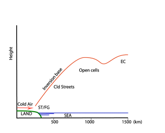
). As the cold air leaves the land or ice surface it is modified by vertical transfer of heat and moisture from the underlying water surface. An inversion will be formed the base of which rises with the distance from shore. The formation of the inversion is, in many cases, stimulated by NVA and subsequent sinking motion in the stream upwind of the 500 hPa trough-axis (see image below).
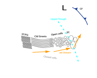
The transformation of the air mass eventually leads to the formation of clouds which, under certain circumstances, take the form of Cloud Streets, and develop roughly parallel to the wind direction (see graphic below). Further downwind from the outbreak, the unstable layer becomes deeper, the flow becomes more cyclonic and the streets develop into three-dimensional open cells. Near the upper-trough the convection is enhanced by PVA, resulting in the formation of EC (see
Enhanced Cumulus
) and Comma (see
Comma
).
|
|
|
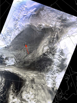
07 March 2003/12.04 UTC - NOAA RGB image
|
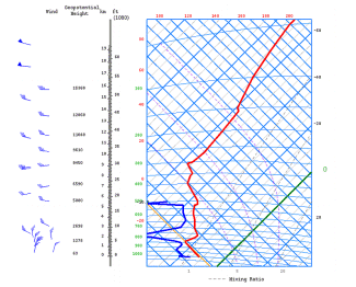
07 March 2003/12.00 UTC - Tephigram Jan Mayen
|
|
|
| Height (hPa) | Winddirection (Deg) | Windspeed (kt) |
| 1007 | 010 | 17 |
| 1000 | 015 | 17 |
| 925 | 020 | 23 |
| 850 | 350 | 25 |
| 772 | 295 | 23 |
| 700 | 295 | 23 |
Over Land:
Cloud Streets also occur over land surfaces. Frequent examples of this type of Cloud Street occur in polar maritime air behind Cold Fonts, when a ridge of high pressure is forming. Heating of the land surface enhances the instability in the lowest layers. The high pressure provides the subsidence inversion which is needed to limit the convection. Furthermore, because of the cold advection the condition of the turning wind vector is also fulfilled and Cloud Streets can develop. As a consequence of a larger variation in terrain roughness, the pattern of the Cloud Streets is less regular than over sea.
|
19 February 2004/12.00 UTC - NOAA Ch1 image, Surface/Geostrophic wind
|
19 February 2004/12.00 UTC - NOAA Ch1 image, Surface/Geostrophic wind
|
|

|
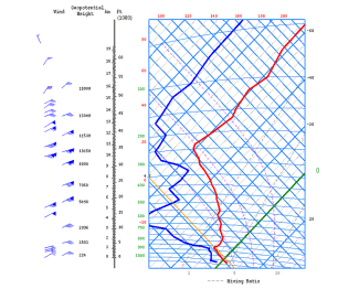
| Height (hPa) | Winddirection (Deg) | Windspeed (kt) |
| 1028 | 060 | 12 |
| 1000 | 065 | 25 |
| 925 | 080 | 25 |
| 850 | 075 | 35 |
| 700 | 065 | 45 |


